- Merstham
-
Coordinates: 51°15′50″N 0°09′09″W / 51.2640°N 0.1525°W
Merstham 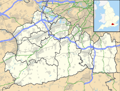
 Merstham
Merstham shown within SurreyPopulation 7,385 [1] OS grid reference TQ295535 District Reigate and Banstead Shire county Surrey Region South East Country England Sovereign state United Kingdom Post town Redhill Postcode district RH1 Dialling code 01737 Police Surrey Fire Surrey Ambulance South East Coast EU Parliament South East England UK Parliament Reigate List of places: UK • England • Surrey Merstham is a village in the Reigate and Banstead borough of Surrey, England, in the London commuter belt. It is just north of Redhill, near the intersection of the M25 and M23 motorways, on the edge of the North Downs and on the North Downs Way.
Contents
History
The area has been settled since pre-Roman times.
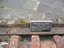 A piece of the Croydon, Merstham and Godstone Railway near Quality Street
The village lay within the Reigate hundred, an Anglo-Saxon administrative division. Its name was recorded in 947 as Mearsætham, which seems to be Anglo-Saxon Mearþ-sǣt-hām = "Homestead near a trap set for [[marten]s or weasels".
Merstham appears in Domesday Book of 1086 as Merstan. It was held by Archbishop Lanfranc of Canterbury. Its domesday assets were: 5 hides; 1 church, 1 mill worth 2s 6d, 10 ploughs, 8 acres (32,000 m2) of meadow, woodland and herbage worth 41 hogs. It rendered £12.[2]
The area has long been known for its quarries, and it was to serve these that the village became the terminus of the Croydon, Merstham and Godstone Railway, an extension of the horse-drawn Surrey Iron Railway of 1803, the world's first public railway[citation needed]. A small section of the railway is on display near Quality Street.
The village's oldest church, St. Katharine's, dates from approximately 1100, and the current building originates from approximately 1220.
Merstham's most historic street is called 'Quality Street'. This was so named after the male and female lead actors in J.M. Barrie's play of the same name lived in the 'Old Forge' at the end of the street.
The earlier of the two Merstham railway tunnels was the scene of a murder on 24 September 1905. The mutilated body of Mary Sophia Money was found in the tunnel and was first thought to be a case of suicide. On inspection, however, a scarf was found in the victim's throat, and marks on the tunnel wall showed that she had been thrown from a moving train. The crime was never solved, but suspicion rested on Miss Money's brother, Robert Money.
After World War II, a large housing estate was built to the south-east of Merstham village. This area has its own shops and amenities, and is usually known as Merstham Estate. South Merstham is south of both mentioned areas and is made up of mainly Victorian and Edwardian terraces, which served Albury Manor. There is currently a new development underway in South Merstham close to Mercers Park, called Water-Colour. The old village is sometimes known as Old or Top Merstham.
Rockshaw Road, in Top Merstham, was developed at the very end of the 19th century and between the World Wars was home to many notable people, among them senior Army and Navy figures, financiers and politicians.[3]
At the junction of Battlebridge Lane and Nutfield Road is All Saints church, the original building of which was destroyed in the war. Volunteers from the Canadian regiments worked to build a temporary church for the village, which became known as Canada Hall and is used as a village hall and weekly meeting hall for some Merstham branches of the Girl Guides.
Transport
Buses run to Croydon, Coulsdon, Purley and Redhill town centre.
The village is served by Merstham railway station on the Brighton Main Line, with services to Croydon, London Bridge and London Victoria, and Gatwick Airport is a few miles to the south.
References
External links
- Merstham Community Facility A Community Centre at the heart of Merstham, we have courses, local groups, meeting rooms and an I.T. cafe.
- Merstham Ward Councillors News, views and discussion from Merstham's Borough and County Councillors.
- Merstham online - the community website with a wealth of information
- Merstham Village
- Merstham Cricket Club
- Merstham F.C. online
- Reigate & Banstead Council
- County Council web site
- The Merstham Tunnel Mystery
- Reigate and Redhill Guide and Directory
- Merstham Massive Community Portal Merstham Community Portal Site
- Merstham's Neighbourhood Police Team
- The Moat House Doctors Surgery Merstham's local Doctors
Towns, villages and hamlets in the Reigate and Banstead District of Surrey, England  Banstead · Burgh Heath · Chipstead · Earlswood · Hooley · Horley · Kingswood · Lower Kingswood · Meadvale · Merstham · Netherne-on-the-Hill · Nork · Redhill · Reigate · Salfords · Sidlow · South Park · Tadworth · Tattenham Corner · Walton-on-the-Hill · Whitebushes · Woodhatch · WoodmansterneCategories:
- Villages in Surrey
- Reigate and Banstead


Wikimedia Foundation. 2010.