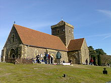
- St. Martha's Hill
-
Coordinates: 51°13′29″N 0°31′44″W / 51.22472°N 0.52889°W
"St. Martha's Church" redirects here. For the Episcopal church in Delaware, United States, see St. Martha's Church, Bethany Beach.St Martha's Hill is a landmark of the parish of St Martha's in Surrey, England, situated between Guildford and Chilworth, Surrey. It is a prominent hill on the Greensand Ridge just to the south of the North Downs in southeast England. The top of the hill provides good views of Newland's Corner and other parts of the Surrey Hills AONB and is a popular wedding venue. The site contains several Megalithic and Neolithic artifacts, dating from as far back as 3500 BCE.
There is a traditional belief that the original name of this hill was Saints and Martyrs Hill, the martyr being St Thomas of Canterbury.[1][2]
St Martha's Church (also known as St Martha-on-the-Hill) sits on the top of the hill and is accessible only by foot. It lies on the Pilgrims' Way and featured briefly in the 1944 film A Canterbury Tale. Parts of the structure have existed since the 12th century and it may have been built as a landmark or beacon to assist travellers.[2] Its current dedication to Saint Martha is one of the few in England: another example being St Martha's in Broxtowe near Nottingham. The church is floodlit during the Christmas season.
The graveyard of the church includes a memorial to actress and singer Yvonne Arnaud, whose ashes were scattered there. There is also the grave of Bernard Freyberg VC, which is in front of the south door of the church. Freyberg won his medal in 1916 as a Lieutenant-Colonel in The Royal West Surrey Regiment. He was a New Zealander who also won the DSO with three bars, and rose to the rank of Lieutenant-General. In 2007 a memorial service was held for him at the church, attended by the New Zealand High Commissioner.
The eastern end of St Martha's Hill is notified as part of Colyers Hanger Site of Special Scientific Interest (SSSI).[3] This area was included in the SSSI for its heathland vegetation communities, including several characteristic acidic grassland plants. Other parts of the hill also have relict heathland vegetation.
The western end of St Martha's Hill is registered common land.[4]
The hill reaches a height of 573 feet (175 m).
References
- ^ Arnold-Forster, Frances (1899). Studies in Church Dedications: Or, England's Patron Saints. London: Skeffington & Son.
- ^ a b Johnson, Walter (1912). "The secular uses of the church fabric". Byways in British Archaeology. Cambridge, England: Cambridge University Press. pp. 131–132.
- ^ Natural England SSSI details search page, giving map, citation and other details for Colyers Hanger SSSI (search for "Colyers Hanger")
- ^ Open Access web page showing areas of Common Land (Select "Area 1" and "Conclusive map", type TQ027483 into the OS Grid Reference box and click "Go".)
External links
- Description from Surrey Wildlife Trust
- St Martha Parish Council
- Campaign for St. Martha's
- Megalithic and Neolithic information
- Stained Glass Windows at Church, St Martha On The Hill, Surrey
Surrey Hills Area of Outstanding Natural Beauty North Downs Botley Hill · Box Hill · Combe Bottom · Gatton Park · Hackhurst and White Downs · Headley Heath · Hog's Back · Mole Gap to Reigate Escarpment · Newlands Corner · Norbury Park · Ranmore Common · Seale Chalk Pit · Woldingham and Oxted DownsGreensand Ridge Albury Heath · Blackheath · Colyers Hanger · Devil's Jumps · Devil's Punch Bowl · Frensham Common · Gibbet Hill · Gong Hill · Hankley Common · Hankley Farm · Holmbury Hill · Leith Hill · Moor Park · Oxmoor Copse · Puttenham & Crooksbury Commons · St. Martha's Hill · Stockstone Quarry · Thursley Common · Winterfold Forest · Witley CommonLow Weald Rivers Lakes and ponds Long Distance Paths Downs Link · Greensand Way · Mole Gap Trail · North Downs Way · Thames Down Link · Vanguard Way · Wey South PathNational Cycle Routes Categories:- Churches in Surrey
- Visitor attractions in Surrey
- Hills of Surrey
Wikimedia Foundation. 2010.


