- Chilworth, Surrey
-
Coordinates: 51°12′51″N 0°32′18″W / 51.2141°N 0.5383°W
Chilworth 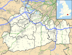
 Chilworth
Chilworth shown within SurreyOS grid reference TQ021471 District Guildford Shire county Surrey Region South East Country England Sovereign state United Kingdom Post town Guildford Postcode district GU4 Dialling code 01483 Police Surrey Fire Surrey Ambulance South East Coast EU Parliament South East England List of places: UK • England • Surrey Chilworth is a village in Surrey, England, 3 miles (4.8 km) southeast of Guildford. Chilworth has about 2000 residents[citation needed], two churches (St Thomas and Chilworth Free Church), two schools (Chilworth Infant School and Tillingbourne Junior School), a pub (The Percy Arms) and a railway station. The village nestles below the North Downs, overlooked by St. Martha's Hill and St. Martha's Church. It is split between two civil parishes, Shalford CP to the west and St Martha's CP to the east, and is wholly within Guildford borough. It also has a recreation ground with a park and pavilion.[1]
The Franciscan friars continue a presence today on the outskirts of Chilworth in the friary, designed by Frederick Walters, founded in 1892.[2]
Contents
History
Chilworth appears in Domesday Book as Celeorde. It was held by the Bishop of Bayeux. Its domesday assets were: 1 mill worth 7s, 3 ploughs. It rendered £3 10s 0d.[3]
The settlement has an interesting industrial past. At various times in history it has been the location of a wire mill, paper mill and gunpowder factory[citation needed]. The wireworks was built in 1603[citation needed] by Thomas Steere and others, who seduced workmen from the Tintern wireworks of the Company of Mineral and Battery Works. This infringed the company's patent and enabled it to have the wireworks suppressed in 1606.[4]
Chilworth Gunpowder works was established in 1625 by the East India Company and finally closed in 1920. It was worked by a number of private companies and became an important supplier of gunpowder to the Government. A significant number of buildings from the gunpowder factory can still be found. The buildings and area are now looked after by Guildford Borough Council and English Heritage.
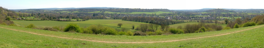
 Chilworth from the hill to the north
Chilworth Manor
Chilworth Manor,[5] midway between Chilworth village and St Martha's Hill to the North, was recorded in the Domesday Book as a monastery. The monastery was destroyed by Henry VIII and by 1580 was owned by William Morgan. William's son, John was knighted at Cadiz in 1596.
Sir Ernest Randyll, whose family held Chilworth for over a century, married John's daughter. During the time that Chilworth Manor was owned by the Randylls, the South front was built. This is the earliest recognisable part of the Manor - the architect is unknown. Morgan Randyll was MP for Guildford from 1680 to 1712. As a result of the costs involved in the Elections, the property was sold to Richard Houlditch, a director of the South Sea Company. After losses involved with the 1720 South Sea Bubble, the manor was again sold.
In 1725 Sarah, the widow of the Duke of Marlborough became owner. She added the Marlborough Wing, developed a tiered garden excavated in the sloping hillside and still known as the "Duchess's Garden". It then passed through inheritances to the Duke of Northumberland who held it until the 1930s.
Sir Lionel and Lady Heald lived at the manor for over 60 years. He was attorney General in Churchill's government. She worked for many charitable causes including he National Garden Scheme of which she was chairwoman.
Since Lady Heald's death in 2004 extensive restoration work has been carried out and the garden, fittingly, opened as part of the National Garden Scheme.
Transport
Chilworth railway station is situated on the North Downs Line, and is served every two hours by trains to Redhill and Reading. Numerous bus services link Chilworth to Guildford and Dorking, of which most are operated by Arriva Guildford & West Surrey.
Telecommunications
Chilworth is covered by ADSL and Mobile Broadband based "High Speed Internet" services. A Vodafone U.K. cell phone mast sits near the center of the village, at the playing fields, just to the south of the Railway Crossing. Other mobile services in the village are patchy.
There are no Cable Internet services covering the village. ADSL based services only offer a maximum of ~4mbps to the village, dwindling to no service at all on the Eastern end of the village with Roseacre Gardens being one of the worst to suffer.On 30 March 2010 BT announced their Fibre to the Cabinet expansion plans to cover Guildford. Chilworth will benefit from these improvements and extensive BT work has been taking place in April and May 2011 resulting in major dig works along New Road and installation of new FTTC cabinets in at least 3 locations in the village. It is thought that these works, once complete (Est. Oct 2011), will allow for 12mbps+ services and service to those at the Eastern end of the village and up to 40mbps to those towards the West end of Dorking Road and New Road.
(Note to residents; A specific FTTC service is required such as BT Infinity or other providers who offer a specific "Fibre" service. Existing contracts and services will see no improvement.).
External links
References
- ^ Ordnance Survey Explorer map 145 edition B1 revised 2004.
- ^ English heritage review of diocesan churches
- ^ Surrey Domesday Book
- ^ M. B. Donald, Elizabethan Monopolies: the history of the Company of Mineral and Battery Works from 1565 to 1604 (Oliver and Boyd, Edinburgh 1961), 136-7.
- ^ Leaflet published by manor as part of National Garden Scheme open day May 2008.
Towns, villages and hamlets in the Guildford District of Surrey, England  Albury · Artington · Ash · Ash Vale · Burntcommon · Burpham · Chilworth · Compton · East Clandon · East Horsley · Effingham · Fairlands · Farley Green · Gomshall · Guildford · Jacobs Well · Merrow · Normandy · Ockham · Onslow Village · Peaslake · Pirbright · Puttenham · Ripley · Seale · Shalford · Send · Shere · St Martha · Stoughton · Tongham · Wanborough · West Clandon · West Horsley · Wisley · Wood Street Village · WorplesdonCategories:
- Villages in Surrey


Wikimedia Foundation. 2010.