- Marches Way
-
Marches Way 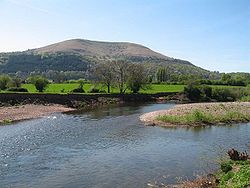
The trail follows the River Usk near Abergavenny Length 218 miles (351 km) Location Wales & Midlands, England Trailheads Chester
53°11′49″N 2°52′48″W / 53.1969°N 2.8799°W
Cardiff
51°29′06″N 3°11′02″W / 51.485°N 3.184°WUse Hiking Season All year The Marches Way is a partially waymarked long distance footpath in the United Kingdom. It runs 351 kilometres / 218 miles through the Welsh–English borderlands, traditionally known as the Welsh Marches and links the cities of Chester in the north and Cardiff in the south.
Contents
The route
The route starts at Chester at Chester railway station and then follows the valley of the River Dee, Wales southwards before turning east into Malpas, Cheshire and down to Whitchurch, Shropshire before roughly following the B5476 road south to Shrewsbury via Wem. Once past Shrewsbury, the path scales the Long Mynd before entering Church Stretton and the Wenlock Edge before entering Craven Arms, where one has excellent views of Flounder's Folly. The path then passes Stokesay Castle as it heads towards Ludlow. From Ludlow the route winds through the Mortimer Forest as it heads towards Leominster. From here the path climbs Dinmore Hill, crossing the A49 road as it navigates towards Hereford. The path passes through the town centre of Hereford, picking up the River Wye before heading towards Abbey Dore and Abergavenny where the path skirts the outer edge of the Brecon Beacons National Park, climbing and running along the ridge of the Skirrid mountain. The way then follows the Monmouthshire and Brecon Canal to Pontypool before heading towards Caerleon and Newport via the Llandegfedd Reservoir. The path then heads towards its end point at Cardiff Central Railway Station via Caerphilly Common and Castell Coch at Tongwynlais.
It links many of the most important historic sites on both sides of the border, drawing together the history from Roman times, passing through two important Roman forts (Isca Augusta and Burrium), and the turbulent medieval periods when the border lands were contentious power bases vied over by Marcher Lords, Welsh princes and the scenes of rebellions, bloodletting and political power-broking by many of the regions historical characters.
The terrain of the footpath varies greatly as it proceeds from Chester to Cardiff, passing through the flat Cheshire Plain to the steep Shropshire Hills and the mountains of South Wales. The path passes through many woods, forests, river banks and farmland along its journey.
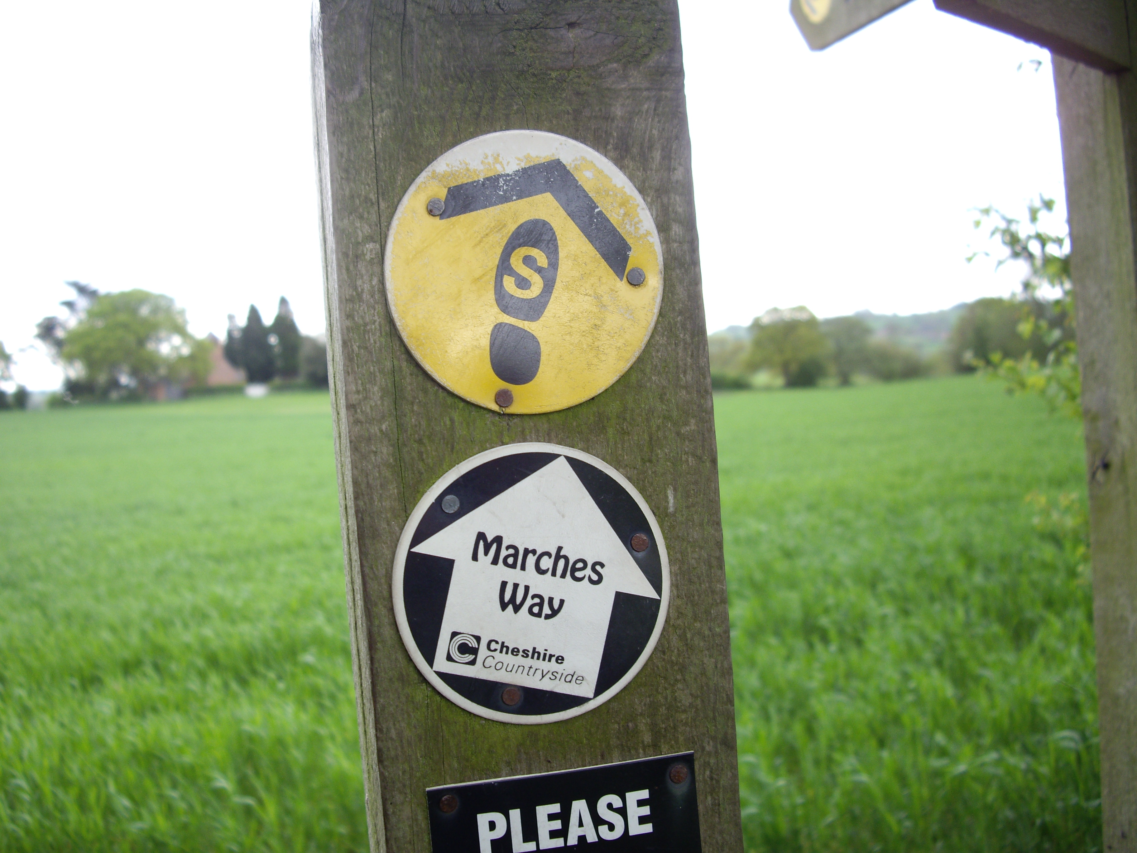
The route is only waymarked in Cheshire with black and white waymarker discs.[1]
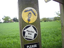 The distinctive waymarks of the Marches Way and Sandstone Trail near Old St. Chads Chapel, Tushingham, Cheshire.
Linked footpaths
The route crosses many different trails along its 218 miles including:
- The Baker Way at Chester Railway Station
- The Sandstone Trail at Tushingham (going past Old St. Chads Chapel)
- The Maelor Way and South Cheshire Way at Grindley Brook
- The Shropshire Way at various points in Shropshire
- The Mortimer Trail in the Mortimer Forest, Herefordshire
- The Black and White Trail at Leominster.[2]
- The Herefordshire Trail at various points in Herefordshire
- The Offa's Dyke Path and the Beacons Way at Pandy
- The Taff Trail at Tongwynlais, Cardiff
Mapping
The Marches Way was removed from the Ordnance Survey map series in 2004 after only being detailed on these particular maps for approximately 5 years. The Ordnance Survey maps which included the Marches Way between 1999 and 2004 were:
- OS Explorer OL13 - Brecon Beacons National Park (East)
- OS Explorer 151 - Cardiff and Bridgend
- OS Explorer 152 - Newport and Pontypool
- OS Explorer 166 - Rhondda and Merthyr Tydfil
- OS Explorer 189 - Hereford and Ross-on-Wye
- OS Explorer 202 - Leominster and Bromyard
- OS Explorer 203 - Ludlow, Tenbury Wells and Cleobury Mortimer
- OS Explorer 217 - The Long Mynd and Wenlock Edge
- OS Explorer 241 - Shrewsbury
- OS Explorer 257 - Crewe and Nantwich
- OS Explorer 266 - Chester and the Wirral
- OS Landranger 117 - Chester and Wrexham
- OS Landranger 126 - Shrewsbury and Oswestry
- OS Landranger 137 - Church Stretton and Ludlow
- OS Landranger 138 - Kidderminster and Wyre Forest
- OS Landranger 148 - Presteigne and Hay-on-Wye
- OS Landranger 149 - Hereford and Leominster
- OS Landranger 161 - The Black Mountains
- OS Landranger 171 - Cardiff and Newport
Misconception about the Length of the Footpath
The Marches Way footpath is often specified as being 204 miles in length. This is not so. The actual distance from start to finish is 218 miles. This error is believed to have been started in the footpath guide by Les Lumsdon where a simple arithmetic error has been made; if one adds up all the distances of each section of the walk, the sum totals to 218 miles. This error has then spread throughout other publications since the walk is not often walked and even more rarely its distance measured accurately. This distance error has also been confirmed by accurate GPS data collected during the walk, showing a total distance of 218 miles.
References
- ^ Cheshire local government list of walks
- ^ "The Marches Way by Les Lumsdon", Sigma Leisure 1992. ISBN 1-85058-269-6
External links
- The Ramblers Association - basic info on the Marches Way
- Photo of the trail near the Old School, Llanhennock, Monmouthshire
- Photo on the bank of the River Dee
Long-distance footpaths in the United Kingdom National Trails (England and Wales) Long Distance Routes (Scotland) Transport in Powys Road 
Footpaths Beacons Way · Cambrian Way · Epynt Way · Glyndŵr's Way · Marches Way · Offa's Dyke Path · Sarn Helen · Severn Way · Usk Valley Walk · Wye Valley WalkCycle routes Celtic Trail · Elan Valley Trail · Lake Vyrnwy Road Circuit · Lon Cambria · Lôn Las Cymru · Radnor Ring · Taff TrailRailway stations Cambrian Line Heart of Wales Line Builth Road · Cilmeri · Dolau · Garth (Powys) · Knucklas · Llanbister Road · Llandrindod · Llangammarch · Llangynllo · Llanwrtyd · Pen-y-Bont · Sugar Loaf
Welshpool and Llanfair
Light RailwayCastle Caereinion · Cyfronydd · Heniarth · Llanfair Caereinion · Sylfaen · Welshpool Raven Square
Categories:- Long-distance footpaths in the United Kingdom
- Recreational walks in Wales
- Visitor attractions in Cheshire
- Footpaths in Cheshire
- Visitor attractions in Shropshire
- Visitor attractions in Herefordshire
- River Usk
- Footpaths in Powys
- Transport in Monmouthshire
- Transport in Herefordshire
- Footpaths in England


Wikimedia Foundation. 2010.