- Moel Famau
-
Moel Famau 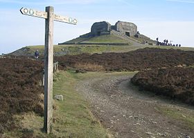
The Jubilee Tower at the summit of Moel Famau.Elevation 554 m (1,818 ft) Prominence c. 272 m Parent peak Moel y Gamelin Listing Marilyn, Council top Translation Hill of the Mothers (Welsh) Pronunciation Welsh: [ˈmɔil ˈvamai] Location Location Clwydian Range,  Wales
WalesCoordinates 53°09′16″N 3°15′21″W / 53.1545°N 3.2559°W Topo map OS Landranger 116 Moel Famau (English: Mother Mountain[1]) is the highest hill within the Clwydian Range on the border between Denbighshire and Flintshire in North Wales. The hill, which also gives its name to the Moel Famau country park, has been classed as an Area of Outstanding Natural Beauty since 1985. It is also surrounded by several well-preserved Iron-Age hill forts.
A northern part of the Offa's Dyke footpath, one of the UK's most popular National Trails, crosses the summit of Moel Famau and the Jubilee Tower.
Contents
Country Park
The park, which covers an area over 8 km², is managed by Denbighshire Countryside Service which is responsible for the heather moorland, dry stone walls and access paths, and provides information and facilities for visitors. The area is home to wildlife such as Red Grouse, European Stonechat and Eurasian Curlew.
The Forestry Enterprise manage the neighbouring forest as a sustainable conifer plantation for timber production and tourism.
Walking
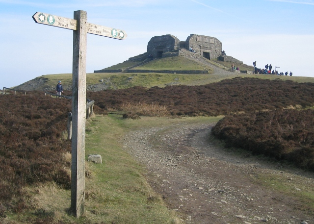
 Path from Bwlch Penbarras towards the summit of Moel Famau.
Numerous well-maintained trails of varying difficulty can be used to reach the summit. Two of the most popular, easiest paths start from the southern car parks within Bwlch Penbarras between Moel Famau and Foel Fenlli about 2 kilometres (1.2 mi) from the summit. The northern route begins from the Iron-Age hill fort at Moel Arthur. A footpath to the top of Moel Famau also begins from the village of Cilcain.
Much of the North West of England and Wales can be seen from the summit of Moel Famau. This includes parts of Cheshire, Merseyside, Denbighshire and Flintshire. On clear days, Snowdonia can be seen to the west, the Irish Sea to the north, and to the East Liverpool, Chester, Winter Hill, and the Blackpool Tower.
Jubilee Tower
The tower, which was built to commemorate the golden jubilee of George III in 1810, was designed by Thomas Harrison of Chester. It was designed like an Egyptian obelisk with three tiers. Although the foundation stone was laid in 1810 by George Kenyon, 2nd Baron Kenyon, the tower was never completed due to a lack of funds. In 1862, a major storm brought down the incomplete tower. The remaining upper part of the structure was demolished for safety reasons leaving just the base. Most of the rubble was removed from the site; smaller stonework was reused by local farmers for dry stone walls.
In October 2010, a celebration was observed by local communities, in both Flintshire and Denbighshire, to mark the 200th anniversary of the laying of the Jubilee Tower's foundation stone. An artistic light and laser installation by a local artist was commissioned by the local authorities to illuminate the tower.
External links
- Moel Famau country park
- Moel Famau News
- Computer generated summit panoramas Moel Famau index
- www.geograph.co.uk : photos of Moel Famau and surrounding area
References
Categories:- Country parks in the United Kingdom
- Marilyns of Wales
- Mountains and hills of north Wales
- Country parks in Wales
- Thomas Harrison buildings


Wikimedia Foundation. 2010.