Moel y Gaer, Llanbedr

Moel y Gaer, Llanbedr
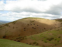
View of Moel y Gaer from the south

Moel y Gaer (Welsh for "bald hill of the fortress") is an Iron Age hill fort located on a western spur of the Clwydian Range, near the village of Llanbedr, Denbighshire, Wales.

The defensive works at Moel y Gaer consist of a double bank and a ditch with two entrances, one on the west and one on the northeast. There is an additional bank to the northeast, across the ridge connecting the hill to the higher ground leading to Moel Famau.[1] A 2007 survey of the site reported that the defensive structures enclosed an area of 2.63 hectares (6.5 acres), with a possible annex including another 0.26 hectares (0.64 acre); it also identified 15 roundhouse platforms within the enclosure, along with possible evidence that the inner rampart was faced with stone at some time during the site's occupation.[2]

See also

References

  1. ^ "Heather and Hillforts: The Clwydian Hillforts Condition Survey". Clwyd-Powys Archaeological Trust. http://www.cpat.org.uk/projects/longer/clwydian/clwydian.htm. Retrieved 26 September 2009. 
  2. ^ Brooks, I. P.; K. Laws (2007). Heather and Hillforts Survey Report: Moel y Gaer, Llanbedr. Engineering Archaeological Services Ltd. p. 3. http://www.heatherandhillforts.co.uk/images/stories/moel_y_gaer_llanbedr2.pdf. Retrieved 26 September 2009. 

External links

Coordinates: 53°08′46″N 3°16′28″W / 53.1461°N 3.2744°W / 53.1461; -3.2744


Wikimedia Foundation. 2010.

Игры ⚽ Поможем решить контрольную работу

Look at other dictionaries:

  • Moel y Gaer — (also Moel y Gaer or Moel y gaer) may refer to any of several prehistoric hill forts in Wales: Moel y Gaer, Bodfari, on a hill overlooking the Wheeler Valley in Denbighshire Moel y Gaer, Llanbedr, on a western spur of the Clwydian Range in… …   Wikipedia

  • Moel Maelogan — Coordinates: 53°08′07″N 3°43′25″W / 53.13518°N 3.72371°W / 53.13518; 3.72371 …   Wikipedia

  • Dolgarrog — is a small village in the Conwy County Borough in North Wales situated between Llanrwst and Conwy, very close to the Conwy River. The village is well known for its industrial history since the 18th century and the Eigiau dam disaster, which… …   Wikipedia

  • River Conwy — Conwy (Afon Conwy) River Boats in the river estuary at Conwy …   Wikipedia

  • Conwy — This article is about the town. For other uses, see Conwy (disambiguation). Coordinates: 53°17′N 3°50′W / 53.28°N 3.83°W / 53.28; 3.83 …   Wikipedia

  • Maenan — is a rural community in Conwy, Wales, located approximately 4 miles to the north of Llanrwst and 3 miles to the south of the village of Eglwysbach. The population of the area is approximately 300 people, and more than 75% of the population are… …   Wikipedia

  • Mynydd Hiraethog — (also known as the Denbigh Moors) is an upland region in Conwy and Denbighshire in north east Wales. It includes the large reservoir Llyn Brenig and the Clocaenog Forest, which has one of Wales s last populations of red squirrels. Its highest… …   Wikipedia

  • Dolwyddelan — Castle on its hill Part of the village of Dolwyddelan …   Wikipedia

  • Conwy Valley Line — Overview Type Heavy Rail Locale Conwy Gwynedd …   Wikipedia

  • Conwy Castle — Part of the County Borough of Conwy Conwy, Wales …   Wikipedia

Share the article and excerpts

Direct link
Do a right-click on the link above
and select “Copy Link”