- Gowrie, Australian Capital Territory
Infobox Australian Place | type = suburb
name = Gowrie
city = Canberra
state = Australian Capital Territory
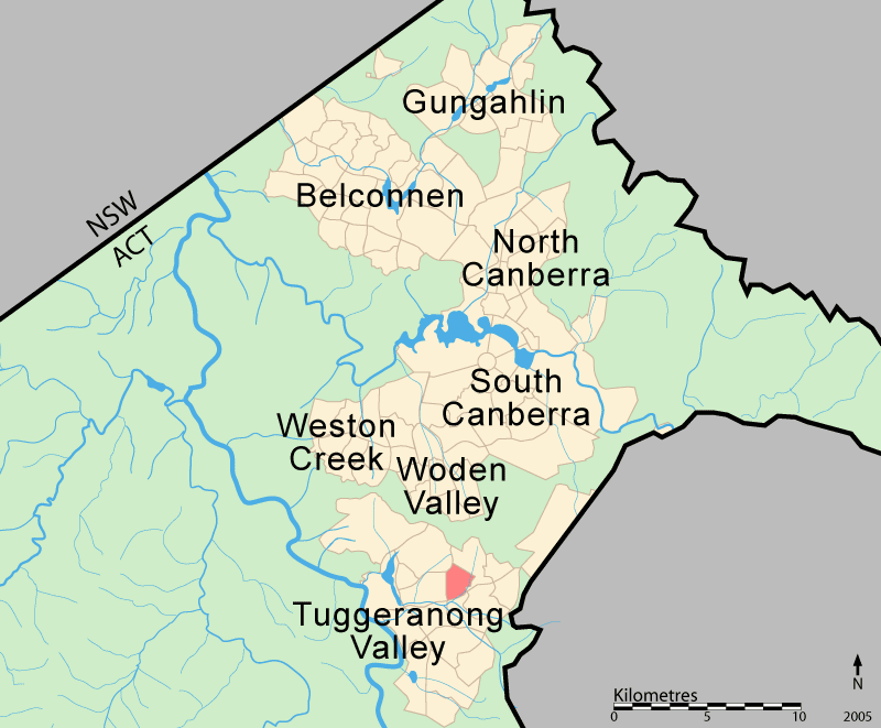
lga =Tuggeranong
ACTgov = Brindabella
fedgov = Canberra
est = 1981
postcode = 2904
pop = 2,972 (2001 census)
propval = AU$442,000 (2006) [cite web
title =Gowrie ACT
publisher =allhomes.com.au
url =http://allhomes.com.au/c/ah?a=uisu&i=342
accessdate = ]
near-nw = Wanniassa
near-n =
near-ne = Fadden
near-w = Monash
near-e =
near-sw = Isabella Plains
near-s = Richardson
near-se = ChisholmGowrie is a
suburb ofCanberra ,Australia , located in the northern end of theTuggeranong Valley . Tuggeranong suburbs are the southernmost of Australia's capital city. Gowrie is named after theEarl of Gowrie ,Brigadier-General Alexander Gore Arkwright Hore-Ruthven (1872-1955),Governor-General of Australia from 1936-1944.Gowrie's streets are all named after members of the
Australian Defence Force who won decorations, including theVictoria Cross . Gowrie is the former site of the Athllon Homestead.Demographics
There were 3285 people living in Gowrie on Census night 2001. The median age of people in Gowrie was 31 years, compared to a median age of 32 for Canberra. Unemployment in Gowrie was one percent lower than the Canberra average. The median individual income for Gowrie in 2001 was $500–$599, the same as for Canberra, while the median household income was $1200-$1499. In 2001 the median monthly housing loan repayment in Gowrie was $800-$999.Census 2001 AUS|id=805253339|title=Gowrie (Statisical Local Area)|accessdate=2007-06-29] [Census 2001 AUS|id=805|title=Canberra (Statisical Division)|accessdate=2007-06-29]
The residents of Gowrie are predominantly Australian born, with 78.7% being born in Australia. The three main countries of birth for those born overseas were
United Kingdom , 5.3%,New Zealand , 1.1%, andItaly , 0.9%. The most popular religious affiliations in descending order are Catholic, Anglican, no religion, Uniting,Presbyterian and otherChristian .uburb amenities
Gowrie Primary School, located on Jeffries Street, opened in 1983. [ Gowrie Primary School (2006) [http://www.gowrieps.act.edu.au/profile/the_suburb_gowrie Gowrie Primary School: The suburb Gowrie] , retrieved 1 July 2006 ] The school's design has a rural theme, and each of the buildings are named after properties in the Tuggeranong Valley. [ Gowrie Primary School (2006) [http://www.gowrieps.act.edu.au/profile Gowrie Primary School: Profile] , retrieved 1 July 2006 ] . The theme song for Gowrie Primary School is: "G-O-W-R-I-E, Gowrie is our school..."The Catholic Holy Family Parish Primary School and the Holy Family Church, both part of the South Tuggeranong Corpus Christi Parish, are located on Bugden Avenue. [The Archdiocese of Canberra & Goulburn (2006) [http://www.cangoul.catholic.org.au/ppr/parishes.asp?action=showresults&session={7%2F1%2F2006+8%3A55%3A58+PM} Parish section of the Archdiocese of Canberra & Goulburn website] , retrieved 1 July 2006 ]
The Gowrie local shopping centre is located on Jeffries Street. The centre includes a
supermarket ,pharmacy ,hairdresser and physiotherapist.Jeffries Street is also the site of a child care centre and the Gowrie Preschool. The Erindale Scout Hall is in Finlay Place. [ Erindale Scout Group (2006) [http://www.act.scouts.asn.au/ACTScouts/Sites/ERINDALE/Home.asp Home] , retrieved 1 July 2006 ] The Gowrie District Playing fields also are located in the suburb.Gowrie is serviced by several ACTION bus routes. Routes 65 and 67 run between the Tuggeranong and Woden Interchanges every 20 to 60 minutes between 7:00 a.m. and 7:00 p.m. The additional services 265 and 267, following the same routes through Gowrie as 65 and 67 respectively, run during peak hour from the Tuggeranong Interchange to City West. Route 170 also runs in peak hour from Monash to City West. Flexibus service 967 leaves the Tuggeranong Interchange every hour from 9:00 p.m. to 11:00 p.m. and the Erindale Shops every hour from 8:30pm to 11:30 p.m., and services the suburbs of Gowrie, Fadden and Macarthur. [ ACTION Buses(2006) [http://www.action.act.gov.au/ ACTION Buses] , retrieved 2 July 2006 ]
Politics
Gowrie is located within the federal
electorate of Canberra. The electorate is currently represented in the House of Representatives byAnnette Ellis . Canberra is considered a safe Labor seat. [Australian Electoral Commission (2005) [http://www.aec.gov.au/profiles/c/canberra.htm Canberra] , retrieved 28 May 2006 ] The 2004 Federal election saw a 3.6% and 4.2% swing towards Labor and the Greens respectively, and a swing of 5.1% away from the Democrats.In the ACT Legislative Assembly, Gowrie is in the electorate of Brindabella, which is currently represented by three Labor and two Liberal members. [ACT Electoral Commission (2001) [http://www.elections.act.gov.au/adobe/LocalitiesColour.pdf List of Localities] , retrieved 28 May 2006 ] [ACT Electoral Commission (2005) [http://www.elections.act.gov.au/Result04.html ACT Electoral Commission - 2004 Election] , retrieved 28 May 2006 ] The 2004 ACT election saw a swing of 9.7% towards the Liberals, 4.4% towards the Greens and 5.2% against the Democrats. [ ACT Electoral Commission (2005) [http://www.elections.act.gov.au/FirstPref01.xls#BrinPP!A1 FirstPref01] , retrieved 25 June 2006 ] Polling place statistics are shown above for the Gowrie polling place in the 2004 federal and ACT elections.
Geology
The west of Gowrie is built on Deakin Volcanics green-grey and purple
rhyodacite . In the east, Gowrie is built on green-grey, purple and creamrhyolite . These rocks are 414 Million years old from theSilurian period. [Henderson G A M and Matveev G, Geology of Canberra, Queanbeyan and Environs 1:50000 1980.] See also|Geology of the Australian Capital TerritoryReferences
[ [http://www.ga.gov.au/bin/gazm01?placename=Gowrie&placetype=R&state=ACT Place names search, Geoscience Australia ] ]
Wikimedia Foundation. 2010.