- Chisholm, Australian Capital Territory
-
Chisholm
Canberra, Australian Capital Territory
Population: 5,378 (2006 census)[1] Established: 1982 Gazetted: 5 August 1975 Postcode: 2905 District: Tuggeranong Assembly Electorate: Brindabella Federal Division: Canberra Suburbs around Chisholm: Richardson Fadden Macarthur Bush Chisholm Richardson Richardson Richardson Canberra Nature Park Chisholm is a suburb in the Canberra, Australia district of Tuggeranong, named after Caroline Chisholm.[2]
It was gazetted on 5 August 1975, and streets are named after notable women.[2]
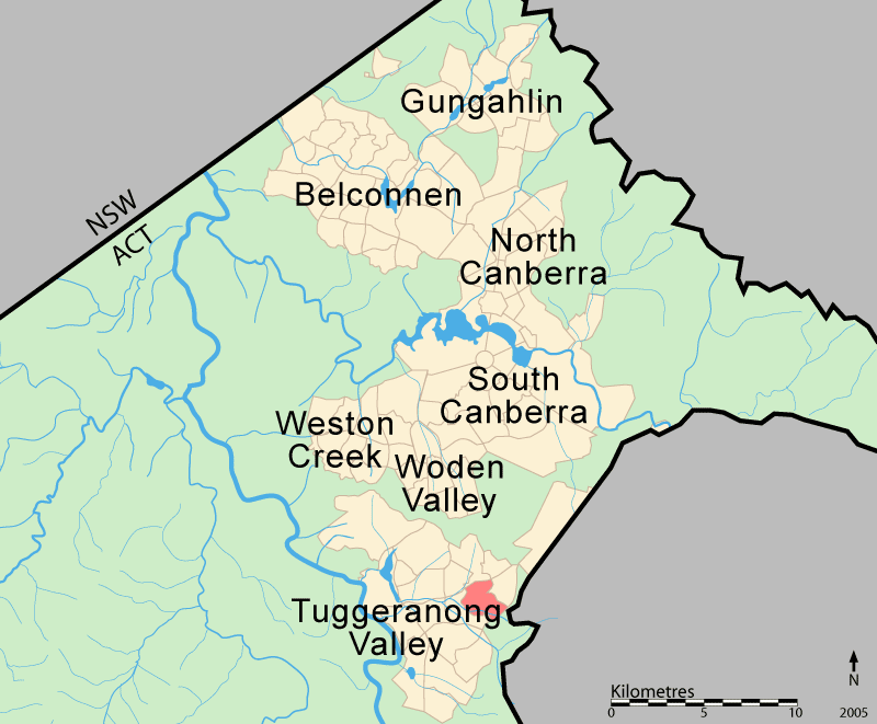
It is nearby suburbs of Gilmore, Fadden, and Richardson. It is bounded by Isabella Drive, and the Monaro Highway. Chisholm and Gilmore are separated by Simpsons Hill, which provides some wilderness with walking tracks over it, popular for walking dogs.
Contents
Demographics
On Census night 2006, Chisholm had a population of 5,378 people.[1] The median age of people in Chisholm was 29 years, compared to a median age of 32 for Canberra. Unemployment in Chisholm was half a percent lower than the Canberra average. The median weekly individual income for Chisholm in 2001 was $500–$599, the same as Canberra, while the median weekly household income was $1000–$1199. In 2001 the median monthly housing loan repayment in Chisholm was $800–$999.
The residents of Chishlom are predominantly Australian born, with 80.6% being born in Australia. The three main countries of birth for those born overseas were United Kingdom, 5.0%, New Zealand , 1.0%, and Vietnam, 0.6%. The most popular religious affiliations in descending order are Catholic, Anglican, no religion, Uniting, Presbyterian, Buddhist, Muslim, Lutheran and Orthodox Christian.[1]
Suburb amenities
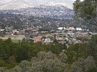 View of Chisholm from Macarthur Hill
Caroline Chisholm School is a newly amalgamated school (2008) that caters for students from Pre school to Year 10. Chisholm High School, now the Senior Campus opened in 1985; the school won the RAIA Canberra Medallion for Outstanding Architecture the following year The senior campus caters for students in Years 6 to 10 and offers a Middle Years Program. Chisholm Primary School, now the Junior Campus caters for students in Preschool to Year 5. Both schools are located on Hambidge Crescent.[3][4][5]
The Chisholm Group Centre is located on Halley Street and Benham Street and has a variety of shops and service outlets. These include a Coles supermarket, tavern, restaurants, general practitioner, dentist, BP service station, Fire Station, Rugby union club, child care and several other businesses.[6] Chisholm also has several sporting facilities: the Chisholm District Playing Fields located on Proctor Street, the Chisholm Neighbourhood Oval on Alston Street and The Pines Tennis Club on Norris Street.
Chisholm is serviced by several ACTION bus routes. Routes 66 and 67 run between the Tuggeranong and Woden Interchanges every 20 to 60 minutes from 6:00 a.m. to 8:00 p.m. Additional service 267 runs during peak hour from the Tuggeranong Interchange to City West and follows the same route through Chisholm as 67. Routes 268 and 269 also run during peak hour, from City West to Theodore. Flexibus service 966 leaves the Tuggeranong Interchange every hour from 8:30 p.m. to 10:30 p.m. and the Erindale Shops every hour from 8:00pm to 11:00 p.m., and services the suburbs of Chisholm, Gilmore and Richardson.[7]
Politics
2004 ACT Election[8] Labor 45% Liberal 44% Greens 6% Christian Democratic Party 2% 2004 Federal Election[9] Labor 52% Liberal 39% Greens 7% Democrats 2% Chisholm is located within the federal electorate of Canberra. The electorate is currently represented in the House of Representatives by Annette Ellis. Canberra is considered a safe Labor seat.[10] The 2004 Federal election saw a swing of 4.7% towards the Liberals, 3.3% towards the Greens, 2.7% towards Labor, 5.9% away from the Democrats and 3.5% away from One Nation.[9]
In the ACT Legislative Assembly, Chisholm is in the electorate of Brindabella, which is currently represented by three Labor and two Liberal members.[11][12] The 2004 ACT election saw a swing of 14.4% towards the Liberals, 0.9% towards the Greens, 2.6% against Labor and 5.0% against the Democrats; several minor parties did not contest the 2004 election.[8][13]
Polling place statistics are shown above for the Chisholm polling place in the 2004 federal and ACT elections.
Geology
The rocks underneath Chisholm are two kinds of volcanic rock that erupted from volcanos in the Silurian period. The name of the member is called Deakin Volcanics. Rhyolite occurs throughout the suburb. Rhyodacite is found around the hill in the east of Chisholm. These rocks can be quite colourful as a result of alteration by water, and can be cream, grey, green, red or purple. The age of the rocks is 414 Mya.[14]
References
- ^ a b c Australian Bureau of Statistics (25 October 2007). "Chisholm (State Suburb)". 2006 Census QuickStats. http://www.censusdata.abs.gov.au/ABSNavigation/prenav/LocationSearch?collection=Census&period=2006&areacode=SSC81086&producttype=QuickStats&breadcrumb=PL&action=401. Retrieved 2009-05-04.
- ^ a b Canberra's suburb and street names : origins and meanings. Department of the Environment, Land and Planning. 1992. p. 18. ISBN 1 86331 128 9.
- ^ Caroline Chisholm High School (2006) CCHS_Home, retrieved 3 July 2006
- ^ Bligh Voller Nield (2006) Bligh Voller Nield - Caroline Chisholm High School, retrieved 3 July 2006
- ^ Chisholm Primary School (2005) About Us, retrieved 1 July 2006
- ^ ACT Planning and Land Authority (2006)ACT GROUP CENTRES - CHARACTERISTICS OF OUTLETS, retrieved 3 July 2006
- ^ ACTION Buses(2006)ACTION Buses, retrieved 3 July 2006
- ^ a b ACT Electoral Commission (2005)FirstPref04, retrieved 24 June 2006
- ^ a b Australian Electoral Commission (2005) Polling Place Results, retrieved 24 June 2006
- ^ Australian Electoral Commission (2005) Canberra, retrieved 24 June 2006
- ^ ACT Electoral Commission (2001) List of Localities, retrieved 24 June 2006
- ^ ACT Electoral Commission (2005) ACT Electoral Commission - 2004 Election, retrieved 24 June 2006
- ^ ACT Electoral Commission (2005)FirstPref01, retrieved 24 June 2006
- ^ Henderson G A M and Matveev G, Geology of Canberra, Queanbeyan and Environs 1:50000 1980.
Coordinates: 35°25′27″S 149°7′21″E / 35.42417°S 149.1225°E
Categories:

Wikimedia Foundation. 2010.