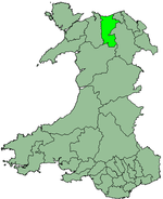
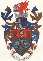
- Colwyn
-
Colwyn 
Geography Status Borough 1974 area 136,566.2 acres (552.664 km2) HQ Colwyn Bay History Created 1974 Abolished 1996 Succeeded by Conwy county borough,
DenbighshireDemography 1973 population 45,990 The Borough of Colwyn was one of six districts of the county of Clwyd, north-east Wales, from 1974 to 1996.
It was formed under the Local Government Act 1972 from the following parts of the administrative county of Denbighshire:
- The municipal borough of Colwyn Bay
- The urban district of Abergele
- Parts of the rural districts of Aled and Hiraethog.[1]
The borough was abolished in 1996, when wales was divided into unitary authorities created by the Local Government (Wales) Act 1994. The area of Colwyn was split: a large part going to Aberconwy and Colwyn county borough, (soon renamed as Conwy), and the remainder going to Denbighshire unitary authority.
Colwyn is twinned with Konstanz, Germany and Roissy-en-Brie, France.
References
Clwyd Dyfed Gwent Gwynedd Mid Glamorgan Powys South Glamorgan West Glamorgan Lliw Valley • Neath • Port Talbot • Swansea
Coordinates: 53°10′N 3°35′W / 53.17°N 3.58°W
Categories:- Former subdivisions of Wales
- Denbighshire
- Districts of Wales abolished in 1996
- Clwyd geography stubs
Wikimedia Foundation. 2010.

