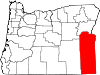
- Nyssa, Oregon
-
Nyssa, Oregon — City — 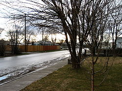
Nickname(s): Thunderegg Capital of the World Motto: Gateway to the Oregon Trail Location in Oregon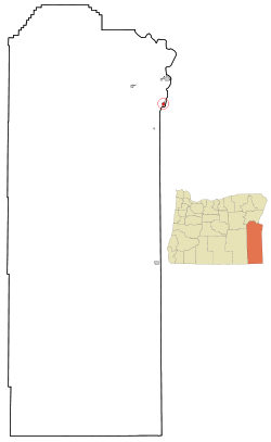
Coordinates: 43°52′45″N 116°59′49″W / 43.87917°N 116.99694°WCoordinates: 43°52′45″N 116°59′49″W / 43.87917°N 116.99694°W Country United States State Oregon County Malheur Incorporated 1903 Government – Mayor Harry Flock[1] Area – Total 1.1 sq mi (3.0 km2) – Land 1.1 sq mi (3.0 km2) – Water 0 sq mi (0 km2) Elevation 2,192 ft (668 m) Population (2000) – Total 3,163 – Density 2,772.6/sq mi (1,071.3/km2) Time zone Mountain (UTC-7) – Summer (DST) Mountain (UTC-6) ZIP code 97913 Area code(s) 541 FIPS code 41-53750[2] GNIS feature ID 1124870[3] Website www.nyssacity.org Nyssa is a city in Malheur County, Oregon, United States. The population was 3,163 at the 2000 census. The city is located along the Snake River on the Idaho border, in the region of far eastern Oregon known as the "Treasure Valley". It is part of the Ontario, OR–ID Micropolitan Statistical Area.
The primary industry in the region is agriculture, including the cultivation of Russet potatoes, sugar beets, onions, corn, flower seed, mint, and wheat. The city's economy relies on the surrounding agricultural area with its several large onion and potato packaging plants.
Contents
History
The area surrounding the city was originally inhabited by Native Americans. Northern Paiute and Cayuse frequented the area but had difficulty living in the relatively harsh climate. The original Fort Boise, established in the 1830s, is nearby to the southeast. The city was originally a shipping center for sheep and stock on the Union Pacific's main trunk line.
Experiments with growing sugar beets were begun in 1935 by R. H. Tallman, the Idaho district manager of the Amalgamated Sugar Company.[4] Successful yields led to the first Amalgamated-designed and built factory, which began operation on October 9, 1938.[4] The factory was located at 43°52′31″N 116°59′26″W / 43.875298°N 116.990629°W, on both the Union Pacific Railroad lines and along U.S. Route 20.[4]
Near the end of World War II, a branch camp for German and Italian prisoners of war from Camp Rupert, near Buhl, Idaho, was established.[5] Those POWs helped with the sugar beet industry, typically through thinning and harvesting.[5]
From 1936 until 2005, the Amalgamated Sugar Company (White Satin brand) owned and operated a sugar-processing plant that served as the city's main source of commerce. The closing of the plant resulted in the loss of 600 seasonal jobs.[6][7]
Geography
According to the United States Census Bureau, the city has a total area of 1.1 square miles (2.8 km2), all of it land.
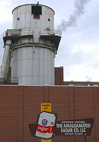 Sugar beet plant of the Amalgamated Sugar Company in Nyssa
Demographics
As of the census[2] of 2000, there were 3,163 people, 1,018 households, and 761 families residing in the city. The population density was 2,772.6 people per square mile (1,071.3/km²). There were 1,099 housing units at an average density of 963.4 per square mile (372.2/km²). The racial makeup of the city was 56.50% White, 0.41% African American, 0.79% Native American, 1.01% Asian, 0.09% Pacific Islander, 38.22% from other races, and 2.97% from two or more races. Hispanic or Latino of any race were 57.19% of the population.
There were 1,018 households out of which 43.3% had children under the age of 18 living with them, 56.5% were married couples living together, 13.4% had a female householder with no husband present, and 25.2% were non-families. 20.6% of all households were made up of individuals and 12.3% had someone living alone who was 65 years of age or older. The average household size was 3.11 and the average family size was 3.61.
In the city the population was spread out with 35.7% under the age of 18, 9.5% from 18 to 24, 25.8% from 25 to 44, 17.2% from 45 to 64, and 11.9% who were 65 years of age or older. The median age was 29 years. For every 100 females there were 99.2 males. For every 100 females age 18 and over, there were 95.0 males.
The median income for a household in the city was $27,372, and the median income for a family was $28,919. Males had a median income of $26,731 versus $20,667 for females. The per capita income for the city was $10,317. About 19.9% of families and 23.3% of the population were below the poverty line, including 28.2% of those under age 18 and 15.6% of those age 65 or over.
References
- ^ "City Council". http://www.nyssacity.org/CityGovernment/CityCouncil/tabid/3446/language/en-US/Default.aspx. Retrieved 24 May 2010.
- ^ a b "American FactFinder". United States Census Bureau. http://factfinder.census.gov. Retrieved 2008-01-31.
- ^ "US Board on Geographic Names". United States Geological Survey. 2007-10-25. http://geonames.usgs.gov. Retrieved 2008-01-31.
- ^ a b c Bachman, J. R. (1962). Story of the Amalgamated Sugar Company, 1897-1961. Caldwell, Idaho: Caxton Printers. OCLC 18047844.
- ^ a b Jaehn, Tomas (2000-08). "Unlikely Harvesters: German Prisoners of War as Agricultural Workers in the Northwest". Montana: The Magazine of Western History (Montana Historical Society) 50 (3): 46–57. JSTOR 4520253.
- ^ Cockle, Richard (2005-10-30). "Nyssa feels bare without bustle of beets". The Oregonian: pp. C04.
- ^ Cockle, Richard (2001-01-25). "SWEET ON SUGAR BEETS". The Oregonian: pp. D02.
External links
Municipalities and communities of Malheur County, Oregon Cities Adrian | Jordan Valley | Nyssa | Ontario | Vale
Unincorporated
communitiesCategories:- Cities in Oregon
- Populated places in Malheur County, Oregon
- Ontario micropolitan area


Wikimedia Foundation. 2010.