- Moroto District
-
Moroto District — District — District location in Uganda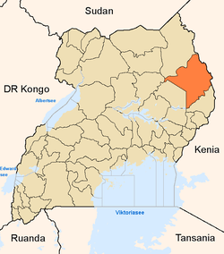
Coordinates: 02°32′N 34°40′E / 2.533°N 34.667°E Country  Uganda
Region Northern Uganda Sub-region Karamoja sub-region Capital Moroto Population (2010 Estimate) - Total 97,900 Time zone EAT (UTC+3) Website Homepage Moroto District is a district in Northern Uganda. Like many other Ugandan districts, it is named after its 'chief town', Moroto, where the district headquarters are located.
Contents
Location
Moroto District is bordered by Kaabong District to the north, the Republic of Kenya to the east, by Amudat District to the south, Nakapiripirit District to the southwest, Napak District to the west and by Kotido District to the northwest.[1] It lies on the foot of Mt. Moroto. The district headquarters at Moroto, are located approximately 210 kilometres (130 mi), by road, northeast of Mbale, the nearest large city.[2] The coordinates of district are:02 32N, 34 40E.
Overview
Moroto District is part of the larger Karamoja sub-region which consists of: Abim District, Amudat District, Kaabong District, Kotido District, Moroto District, Nakapiripirit District and Napak District.[3] In 2002, the population of Karamoja sub-region was estimated at approximately 800,000, by the national census conducted that year.
Moroto District is a plain covered by the Savannah grassland and some low lying rocky hills. It comprises three counties: Bokora County, Matheniko County and Moroto Municipality. It is inhabited by the Karimojong, a distinctive ethnic group that highly cherishes its traditions.
The district is a hub of mineral resources that are yet to be optimally exploited. There are about fifty (50) different minerals and precious stones in the Karamoja region. Of these, Moroto has gold, silver, copper, iron, titanium, manganese, niobium, tantalite and chrome. Other proven minerals include marble, mica, garnets, limestone and asbestos.[4]
Population
The 2002 national census estimated the population of the district, as constituted after July 2010, at about 77,250. It is estimated that the population of the district had grown to about 97,900 by 2010. See table below:;
Moroto District Population Trends Year Estimated Population 2002 77,250 2003 79,600 2004 82,000 2005 84,400 2006 87,000 2007 89,600 2008 92,300 2009 95,000 2010 97,900 Economic activities
Subsistence crop and livestock agriculture form the backbone of Moroto District's economic backbone. [5] Crops raised include:
Recently, commercial cultivation of the Jatropha plant has begun in the region. The seed extract is used as a bio fuel to generate thermal electricity and to power motor engines for trucks and buses. Bee keeping is another activity that is gaining popularity.
Livestock kept includes:
External links
See also
References
 Regions and Districts of Uganda
Central Eastern Amuria · Budaka · Bududa · Bugiri · Bukedea · Bukwa · Bulambuli · Busia · Butaleja · Buyende · Iganga · Jinja · Kaberamaido · Kaliro · Kamuli · Kapchorwa · Katakwi · Kibuku · Kumi · Kween · Luuka · Manafwa · Mayuge · Mbale · Namayingo · Namutumba · Ngora · Pallisa · Serere · Sironko · Soroti · TororoNorthern Western

Wikimedia Foundation. 2010.