- Mukono District
-
"Mukono District" redirects here. For Mukono Town, see Mukono.
Mukono District — District — District location in Uganda Coordinates: 00°20′N 32°45′E / 0.333°N 32.75°E Country  Uganda
Region Central Uganda Capital Mukono Elevation 1,200 m (3,937 ft) Population (2010 Estimate) - Total 583,600 Time zone EAT (UTC+3) Website Homepage Mukono District is a district in Central Uganda. Like most other Ugandan districts, it is named after its 'chief town' - Mukono.
Contents
Location
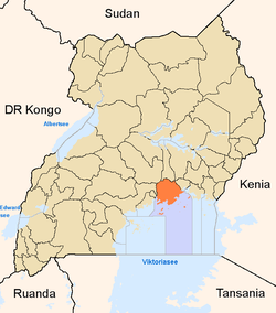
Mukono District is bordered by Kayunga District to the north, Buikwe District to the east, the Republic of Tanzania to the south, Kalangala District to the southwest, Wakiso District and Kira Town to the west and Luweero District to the northwest. Mukono, the main municipal, administrative and commercial center of the district, is located a0proximately 27 kilometres (17 mi), by road, east of Kampala, the capital of Uganda and the largest city in that country.[1] The coordinates of the district are:00 20N, 32 45E.
Overview
Mukono District originally comprised the Buganda Kingdom counties of Kyaggwe, Bugerere and Buvuma. In December 2000, Bugerere was constituted into Kayunga District. In July 2010, Buvuma was granted district status, becoming Buvuma District. The remaining mainland Kyaggwe was also partitioned with the eastern portion becoming Buikwe District.
Administrative Units
As of January 2011[update], Mukono District is made up of (2) counties:
- Nakifuma County and
- Mukono County
The district has within its borders, five (5) urban areas, namely:
- Mukono Town Council
- Nakifuma Town Council
- Kalagi Town Council
- Naggalama Town Council
- Namataba Town Council
The districts headquarters are located in Mukono, 27 kilometres (17 mi) east of Kampala on the Kampala-Jinja Highway.
Demographics
According to the 2002 national census figures, Mukono District had a population of about 423,100, of whom 49.8% were males and 50.2% were females. Then, its population growth rate was projected at 4.1% per annum.[2] It is estimated that the population of the district in 2010, following the creation of Buvuma District and Buikwe District, was approximately 583,600. See table below:
Mukono District Population Trends Year Estimated Population 2002 423,100 2003 440,400 2004 458,500 2005 477,300 2006 496,900 2007 517,300 2008 538,500 2009 560,600 2010 583,600 District Leadership
The leadership is entrusted in the District Executive Council, composed of: [3]
- District Chairman
- District Vice Chairman
- District Secretary for Finance
- District Secretary for Production & Natural Resources
- District Secretary for Works & Technical Services
- District Secretary for Islands (Buvuma and Koome)
- Resident District Commissioner
- Deputy Resident District Commissioner
Tourist attractions
The district is blessed with a favorable climate, abundant rainfall, rich flora/fauna and proximity to urban areas. The major tourist attractions in the district include: [4]
- Lake Victoria
Lake Victoria is the largest lake in Africa and the second largest fresh-water lake in the world. The lake is a lasting source of pleasure. Water sports available on the lake include:
- Sezibwa Falls
In the middle of the district runs river River Sezibwa, believed by Buganda legend to have been born by one 'Nakangu Tibatesa' the wife of 'Nsubuga Sebwaato' in Kawuna, Ngongwe, around the time of the Christian biblical prophet Isaiah. The river flows into lake Kyoga. The nature of its birth makes the river a cultural symbol of great importance to Buganda's heritage.
The falls are located 2.5 kilometres (1.6 mi) off the Kampala-Jinja Highway, 7 miles (11 km) east of Mukono. The falls offer beautiful scenery for tourists and nature lovers. Next to the falls is a spacious ground for campers and holidaymakers. The site also has a natural forest reserve, which has forest trails and nature walkways for birdwatching and forest exploration. Over 100 bird species and some wild animals including rare species of monkeys may be found in this location.
Sezibwa Falls is also a cultural site of the Baganda and has cultural artifacts including caves, 100 year old trees and special rocks of deep cultural significance to the Baganda of Buganda in central Uganda. It is one of the official cultural cites of the Buganda Kingdom.
Other Cultural Sites
Other Buganda cultural sites located in Mukono District include:
- Ngamba Islands in the Koome Archpelago in Lake Victoria
- Ssekabaka Kintu's Palace at Dindo
- Nabitimba Cultural Site - Repository for some of Buganda's Cultural Drums
External links
See also
- Mukono
- Buganda
- Central Region, Uganda
- River Nile
- River Sezibwa
- Districts of Uganda
References
Coordinates: 00°20′N 32°45′E / 0.333°N 32.75°E
 Regions and Districts of Uganda
Central Eastern Amuria · Budaka · Bududa · Bugiri · Bukedea · Bukwa · Bulambuli · Busia · Butaleja · Buyende · Iganga · Jinja · Kaberamaido · Kaliro · Kamuli · Kapchorwa · Katakwi · Kibuku · Kumi · Kween · Luuka · Manafwa · Mayuge · Mbale · Namayingo · Namutumba · Ngora · Pallisa · Serere · Sironko · Soroti · TororoNorthern Western Categories:- Mukono District
- Districts of Uganda
- Central Region, Uganda
- Lake Victoria
Wikimedia Foundation. 2010.

