- Northolt Park railway station
-
Northolt Park 

 Northolt Park
Location of Northolt Park in Greater LondonLocation Northolt Local authority London Borough of Ealing Managed by Chiltern Railways Station code NLT Number of platforms 2 Fare zone 5 National Rail annual entry and exit 2004-05 0.091 million[1] 2005-06 0.084 million[1] 2006-07 0.221 million[1] 2007-08 0.207 million[1] 2008-09 0.123 million[1] 1926 Opened List of stations Underground · National Rail External links Departures • Layout Facilities • Buses Coordinates: 51°33′27″N 0°21′34″W / 51.5574°N 0.3595°W
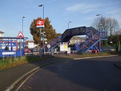
Northolt Park railway station is a Network Rail station in Northolt, Greater London. It is in Cadogan Close and spans the boundary between the London Borough of Harrow and the London Borough of Ealing, with a footbridge connecting the north side (leading to Roxeth and South Harrow) to the south side (leading to Northolt and Greenford).
The service to the station has much improved (until the late 1990s only peak hour trains stopped there). There are improvements in the access to the station as part of the Petts Hill road improvement scheme.
Contents
History
The Great Central Railway line to High Wycombe from Marylebone opened in 1906 but this station (originally known as South Harrow and Roxeth) was not opened until 1926, being given its current name in 1929 [2].
Services
The Monday-Saturday off-peak service currently consists of:
- 2 trains per hour (tph) to London Marylebone, of which:
- 1 calls at Wembley Stadium only, taking 19 minutes.
- 1 calls at Sudbury Hill Harrow (Mondays-Fridays only) and Wembley Stadium, taking 20 minutes.
- 2 tph to High Wycombe, of which:
- 1 calls at South Ruislip, Denham, Gerrards Cross, Seer Green and Jordans and Beaconsfield, taking 31 minutes.
- 1 calls at West Ruislip, Denham, Denham Golf Club, Gerrards Cross, Seer Green and Jordans and Beaconsfield, taking 32 minutes.
On Sundays this becomes:
- 1 tph to London, calling at Wembley Stadium and taking 20 minutes.
- 1 train every 2 hours (tp2h) to Aylesbury, calling at South Ruislip, West Ruislip, Denham, Denham Golf Club, Gerrards Cross, Beaconsfield, High Wycombe, Saunderton, Princes Risborough, Monks Risborough and Little Kimble. This journey takes 1 hour 2 minutes.
- 1 tp2h to Aylesbury, calling at all stations to Denham, Gerrards Cross, Seer Green and Jordans, Beaconsfield and all stations to Aylesbury. This journey takes 1 hour 3 minutes.
Access
Bus services 140, 395, 398, 487 [3] are available on the nearby Northolt Road.
References
- ^ a b c d e "Station usage". Rail statistics. Office of Rail Regulation. 30 April 2010. http://www.rail-reg.gov.uk/server/show/nav.1529. Retrieved 17 January 2011. Please note: Some methodology may vary year on year.
- ^ British History Online - Northolt
- ^ Map: London Buses - NW Greater London
External links
- Chiltern Railways page for Northolt Park station
- [1] [2] [3] Images of Northolt Park
- [4] Google Street View
- Train times and station information for Northolt Park railway station from National Rail
Preceding station  National Rail
Following station South Ruislip Chiltern Railways
London-BirminghamSudbury Hill Harrow
Wembley Stadium on Saturdays
and SundaysRailway stations in the United Kingdom • Railway station categories A B C D E F G H I J K L M N O P Q R S T U V W X Y Z
Railway stations served by Chiltern Railways Current Acocks Green · Amersham · Aylesbury · Aylesbury Vale Parkway · Banbury · Beaconsfield · Bearley · Bicester North · Bicester Town · Birmingham Moor Street · Birmingham Snow Hill · Blakedown · Chalfont & Latimer · Chorleywood · Claverdon · Cradley Heath · Denham · Denham Golf Club · Dorridge · Gerrards Cross · Great Missenden · Haddenham & Thame Parkway · Hagley · Harrow-on-the-Hill · Hatton · Heyford · High Wycombe · Islip · Jewellery Quarter · Kidderminster · King's Sutton · Langley Green · Lapworth · Leamington Spa · Little Kimble · London Marylebone · London Paddington · Lye · Monks Risborough · Northolt Park · Old Hill · Olton · Oxford · Princes Risborough · Rickmansworth · Rowley Regis · Saunderton · Seer Green and Jordans · Small Heath · Smethwick Galton Bridge · Solihull · South Ruislip · Stoke Mandeville · Stourbridge Junction · Stratford-upon-Avon · Sudbury & Harrow Road · Sudbury Hill Harrow · The Hawthorns · Tackley · Tyseley · Warwick · Warwick Parkway · Wembley Stadium · Wendover · West Ruislip · Widney Manor · WilmcoteFuture Water Eaton ParkwayRail transport in the United Kingdom Categories:- Stations in London fare zone 5
- Railway stations in Ealing
- Transport in Harrow
- Former London and North Eastern Railway stations
- Railway stations opened in 1926
- Railway stations served by Chiltern Railways
- DfT Category E stations
- London railway station stubs
- 2 trains per hour (tph) to London Marylebone, of which:


Wikimedia Foundation. 2010.