- Cumberland, Indiana
-
Town of Cumberland, Indiana — Town — A residential neighborhood in northern Cumberland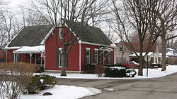 Location in the state of Indiana
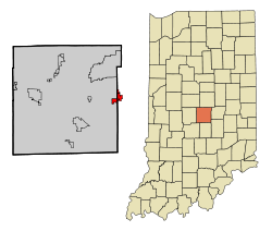
Coordinates: 39°47′1″N 85°57′8″W / 39.78361°N 85.95222°WCoordinates: 39°47′1″N 85°57′8″W / 39.78361°N 85.95222°W Country United States State Indiana Counties Marion, Hancock Area – Total 1.9 sq mi (5.0 km2) – Land 1.9 sq mi (4.9 km2) – Water 0.0 sq mi (0.1 km2) Elevation 853 ft (260 m) Population (2010) – Total 5,169 – Density 2,910.1/sq mi (1,123.6/km2) Time zone EST (UTC-5) – Summer (DST) EST (UTC-5) ZIP code 46229 Area code(s) 317 FIPS code 18-16336[1] GNIS feature ID 0433243[2] Website http://www.town.cumberland.in.us Cumberland is a town split between Hancock and Marion counties in the U.S. state of Indiana. The population was 5,169 at the 2010 census.
Contents
Geography
Cumberland is located at 39°47′1″N 85°57′8″W / 39.78361°N 85.95222°W (39.783528, -85.952308)[3].
According to the United States Census Bureau, the town has a total area of 1.9 square miles (4.9 km2), of which, 1.9 square miles (4.9 km2) of it is land and 0.04 square miles (0.10 km2) of it (1.55%) is water.
Demographics
As of the census[1] of 2000, there were 5,500 people, 2,030 households, and 1,565 families residing in the town. The population density was 2,907.0 people per square mile (1,123.6/km²). There were 2,190 housing units at an average density of 1,157.5 per square mile (447.4/km²). The racial makeup of the town was 85.20% White, 10.56% African American, 0.22% Native American, 1.76% Asian, 0.04% Pacific Islander, 0.75% from other races, and 1.47% from two or more races. Hispanic or Latino of any race were 1.45% of the population.
There were 2,030 households out of which 40.6% had children under the age of 18 living with them, 59.3% were married couples living together, 14.6% had a female householder with no husband present, and 22.9% were non-families. 19.1% of all households were made up of individuals and 5.7% had someone living alone who was 65 years of age or older. The average household size was 2.70 and the average family size was 3.08.
In the town the population was spread out with 30.0% under the age of 18, 7.1% from 18 to 24, 29.9% from 25 to 44, 24.4% from 45 to 64, and 8.6% who were 65 years of age or older. The median age was 34 years. For every 100 females there were 92.5 males. For every 100 females age 18 and over, there were 88.1 males.
The median income for a household in the town was $57,875, and the median income for a family was $61,739. Males had a median income of $48,750 versus $28,239 for females. The per capita income for the town was $24,746. About 5.0% of families and 6.6% of the population were below the poverty line, including 12.2% of those under age 18 and 1.5% of those age 65 or over.
References
- ^ a b "American FactFinder". United States Census Bureau. http://factfinder.census.gov. Retrieved 2008-01-31.
- ^ "US Board on Geographic Names". United States Geological Survey. 2007-10-25. http://geonames.usgs.gov. Retrieved 2008-01-31.
- ^ "US Gazetteer files: 2010, 2000, and 1990". United States Census Bureau. 2011-02-12. http://www.census.gov/geo/www/gazetteer/gazette.html. Retrieved 2011-04-23.
External links
Municipalities and communities of Hancock County, Indiana City 
Towns Cumberland‡ | Fortville | McCordsville | New Palestine | Shirley‡ | Spring Lake | Wilkinson
Townships Blue River | Brandywine | Brown | Buck Creek | Center | Green | Jackson | Sugar Creek | Vernon
Unincorporated
communitiesBowman Acres | Brookville Heights | Carriage Estates | Carrollton | Charlottesville | Cleveland | Colonial Village | Eastgate | Eden | Gem | Maxwell | Milners Corner | Mohawk | Mount Comfort | Nashville | Philadelphia | Pleasant Acres | Reedville Station | Riley | Stringtown | Warrington | Westland | Willow Branch | Woodbury
Footnotes ‡This populated place also has portions in an adjacent county or counties
Municipalities and communities of Marion County, Indiana Cities Beech Grove | Indianapolis (balance) | Lawrence | Southport

Town Townships Included towns
(see Unigov)Clermont | Crows Nest | Cumberland‡ | Homecroft | Meridian Hills | North Crows Nest | Rocky Ripple | Spring Hill | Warren Park | Williams Creek | Wynnedale
Footnotes ‡This populated place also has portions in an adjacent county or counties
Indianapolis metropolitan area Core cities 
Other municipalities over 20,000 population
(in 2010)Brownsburg • Fishers • Franklin • Greenfield • Greenwood • Lawrence • Noblesville • Plainfield • WestfieldMunicipalities 1,000-20,000 population
(in 2010)Arcadia • Avon • Bargersville • Beech Grove • Brooklyn • Cicero • Clermont • Cloverdale • Cumberland • Danville • Edinburgh • Fairland • Fortville • Greencastle • Lebanon • Martinsville • McCordsville • Mooresville • Morristown • New Palestine • New Whiteland • Pittsboro • Princes Lakes • Shelbyville • Sheridan • Speedway • Southport • St. Paul • Thorntown • Whiteland • ZionsvilleCounties Categories:- Populated places in Hancock County, Indiana
- Populated places in Marion County, Indiana
- Towns in Indiana
- National Road
- Indianapolis metropolitan area
- Neighborhoods in Indianapolis, Indiana


Wikimedia Foundation. 2010.