- Whiteland, Indiana
Infobox Settlement
official_name = Whiteland, Indiana
settlement_type =Town
nickname =
motto =
imagesize =
image_caption =
image_
imagesize =
image_caption =
image_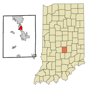
mapsize = 250x200px
map_caption = Location of Whiteland in the state ofIndiana
mapsize1 =
map_caption1 =subdivision_type = Country
subdivision_name =United States
subdivision_type1 = State
subdivision_name1 =Indiana
subdivision_type2 = County
subdivision_name2 = Johnson
subdivision_type3 = Township
subdivision_name3 = Pleasant, Franklin
government_footnotes =
government_type =
leader_title =
leader_name =
leader_title1 =
leader_name1 =
established_title =
established_date =area_footnotes =
unit_pref = Imperial
area_magnitude =
area_total_km2 = 5.9
area_land_km2 = 5.9
area_water_km2 = 0.0
area_total_sq_mi = 2.3
area_land_sq_mi = 2.3
area_water_sq_mi = 0.0population_as_of = 2000
population_footnotes =
population_total = 3958
population_density_km2 = 672.8
population_density_sq_mi = 1742.4timezone = Eastern (EST)
utc_offset = -5
timezone_DST = EDT
utc_offset_DST = -4
elevation_footnotes =
elevation_m = 242
elevation_ft = 794
latd = 39 |latm = 32 |lats = 58 |latNS = N
longd = 86 |longm = 5 |longs = 10 |longEW = Wpostal_code_type =
ZIP code
postal_code = 46184
area_code = 317
blank_name = FIPS code
blank_info = 18-83816GR|2
blank1_name = GNIS feature ID
blank1_info = 0445970GR|3
website =
footnotes =Whiteland is a town in Pleasant and Franklin townships, Johnson County,
Indiana ,United States . The population was 3,958 at the 2000 census.Whiteland is located in north/central Johnson County approximately 19 miles south of
Indianapolis in Johnson County, which is one of the counties circling the capital city itself and therefore considered part of the Indianapolis metropolitan area. Major access roads to get to Whiteland are I-65 (Exit 95 is the Whiteland Exit). South on U.S. 31 from Indianapolis and North from Columbus.Whiteland was incorporated on May 3, 1886; however, the town was beginning to blossom as early as 1858. Three businesses formed the center of Whiteland. When the first plat was laid out, it consisted of 40 lots. Today, Whiteland has approximately 1,600 lots. The estimated population from the U.S. Census Bureau, as of July 1, 2003 is 4,202. This represents about a 2% annual growth rate since the 2000 U.S.
Census .Formal education began when the first school house was built in 1869 and served as the town's school until the 1950s. In 1957, a new high school was built. The Class of 1958 was the first class to graduate from the new Whiteland High School. In 1965, Clark High School and Whiteland High School united to form
Clark-Pleasant Community School Corporation and what is now known asWhiteland Community High School . The old Clark High School becameClark Elementary School and additional schoolsBreak-O-Day Elementary School ,Whiteland Elementary School andClark-Pleasant Middle School were built and opened later in the 1960s and '70s.Clark-Pleasant Intermediate School was added to the district as of 2004 andPleasant Crossing Elementary School is the newest addition, completed in the winter of 2007.Geography
Whiteland is located at coor dms|39|32|58|N|86|5|10|W|city (39.549336, -86.086100)GR|1.
According to the
United States Census Bureau , the town has a total area of 2.3square mile s (5.9km² ), all of it land.Demographics
As of the
census GR|2 of 2000, there were 3,958 people, 1,355 households, and 1,116 families residing in the town. Thepopulation density was 1,742.4 people per square mile (673.2/km²). There were 1,404 housing units at an average density of 618.1/sq mi (238.8/km²). The racial makeup of the town was 98.46% White, 0.05% African American, 0.10% Native American, 0.35% Asian, 0.56% from other races, and 0.48% from two or more races. Hispanic or Latino of any race were 1.09% of the population.There were 1,355 households out of which 47.8% had children under the age of 18 living with them, 70.6% were married couples living together, 9.3% had a female householder with no husband present, and 17.6% were non-families. 13.6% of all households were made up of individuals and 4.6% had someone living alone who was 65 years of age or older. The average household size was 2.92 and the average family size was 3.23.
In the town the population was spread out with 32.2% under the age of 18, 6.2% from 18 to 24, 36.5% from 25 to 44, 18.4% from 45 to 64, and 6.7% who were 65 years of age or older. The median age was 33 years. For every 100 females there were 98.6 males. For every 100 females age 18 and over, there were 95.1 males.
The median income for a household in the town was $56,944, and the median income for a family was $61,810. Males had a median income of $42,247 versus $29,005 for females. The
per capita income for the town was $21,169. About 1.0% of families and 1.9% of the population were below thepoverty line , including 2.6% of those under age 18 and none of those age 65 or over.References
External links
* [http://www.townofwhiteland.com Town of Whiteland's Website] .
* [http://cpcsc.k12.in.us Clark-Pleasant Community School Corporation's Website]
Wikimedia Foundation. 2010.