- Fairland, Indiana
Infobox Settlement
official_name = Fairland, Indiana
settlement_type = CDP
nickname =
motto =
imagesize =
image_caption =
image_
imagesize =
image_caption =
image_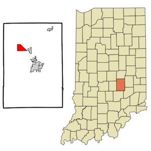
mapsize =
map_caption =
mapsize1 =
map_caption1 =subdivision_type = Country
subdivision_name =United States
subdivision_type1 = State
subdivision_name1 =Indiana
subdivision_type2 = County
subdivision_name2 = Shelby
government_footnotes =
government_type =
leader_title =
leader_name =
leader_title1 =
leader_name1 =
established_title =
established_date =area_footnotes =
unit_pref = Imperial
area_magnitude =
area_total_km2 = 9.0
area_land_km2 = 9.0
area_water_km2 = 0.0
area_total_sq_mi = 3.5
area_land_sq_mi = 3.5
area_water_sq_mi = 0.0population_as_of = 2000
population_footnotes =
population_total = 1276
population_density_km2 = 142.0
population_density_sq_mi = 367.7timezone = Eastern (EST)
utc_offset = -5
timezone_DST = EDT
utc_offset_DST = -4
elevation_footnotes =
elevation_m = 235
elevation_ft = 771
latd = 39 |latm = 35 |lats = 20 |latNS = N
longd = 85 |longm = 51 |longs = 43 |longEW = Wpostal_code_type =
ZIP code
postal_code = 46126
area_code = 317
blank_name = FIPS code
blank_info = 18-22396GR|2
blank1_name = GNIS feature ID
blank1_info = 0434301GR|3
website =
footnotes =Fairland is a
census-designated place (CDP) in Shelby County,Indiana ,United States . The population was 1,276 at the 2000 census.Geography
Fairland is located at coor dms|39|35|20|N|85|51|43|W|city (39.588962, -85.861885)GR|1.
According to the
United States Census Bureau , the CDP has a total area of 3.5square mile s (9.0km² ), of which, 3.5 square miles (9.0 km²) of it is land and 0.04 square miles (0.1 km²) of it (0.57%) is water.Government
The community, located about five miles northwest of Shelbyville, was incorporated as a town on June 9, 1866, but for some undetermined reason, the town board stopped meeting. and town government came to a halt sometime after July 1883.
On August 16, 2008, for the first time in 125 years, a three-member Fairland Town Board and a town clerk-treasurer conducted official business. Shelby County Councilwoman Tami Grubbs administered the oath of office to board members Rick Daily, John Hanson and Jeremy Creech, along with Clerk-Treasurer Chris Brinson, who immediately set about the task of organization, which included electing board officials. The board elected Daily as board president, Hanson as vice president and Creech as secretary. [http://www.shelbynews.com/main.asp?Search=1&ArticleID=57028&SectionID=1&SubSectionID=93&S=1]
Demographics
As of the
census GR|2 of 2000, there were 1,276 people, 462 households, and 369 families residing in the CDP. Thepopulation density was 367.7 people per square mile (142.0/km²). There were 481 housing units at an average density of 138.6/sq mi (53.5/km²). The racial makeup of the CDP was 97.88% White, 0.78% Native American, 0.31% Asian, 0.31% from other races, and 0.71% from two or more races. Hispanic or Latino of any race were 0.78% of the population.There were 462 households out of which 37.2% had children under the age of 18 living with them, 63.6% were married couples living together, 10.6% had a female householder with no husband present, and 20.1% were non-families. 16.5% of all households were made up of individuals and 8.7% had someone living alone who was 65 years of age or older. The average household size was 2.76 and the average family size was 3.07.
In the CDP the population was spread out with 27.7% under the age of 18, 9.5% from 18 to 24, 29.7% from 25 to 44, 23.2% from 45 to 64, and 10.0% who were 65 years of age or older. The median age was 35 years. For every 100 females there were 94.5 males. For every 100 females age 18 and over, there were 96.8 males.
The median income for a household in the CDP was $45,972, and the median income for a family was $50,036. Males had a median income of $27,941 versus $26,458 for females. The
per capita income for the CDP was $17,406. About 5.4% of families and 10.3% of the population were below thepoverty line , including 1.4% of those under age 18 and 14.7% of those age 65 or over.Schools
Triton Elementary School [http://www.nwshelby.k12.in.us/tes/index.htm] , Triton Middle School [http://www.nwshelby.k12.in.us/tms/index.htm] , and Triton Central High School [http://www.nwshelby.k12.in.us/tchs/principal.htm] , which make up the Northwestern Consolidated School District [http://www.nwshelby.k12.in.us/index.html] , are located approximately three miles north of the Town of Fairland. The school colors are
kelly green andwhite , and the mascot is thetiger .Notable natives or residents
Matt Mason (Nov 1985 - Present) -
Country music singerMarjorie Main - actressNotable history
On
September 9 ,1969 ,Allegheny Airlines Flight 853 collided in mid-air with a smaller private aircraft northwest of this town, killing the passengers and crew of both aircraft.References
External links
Wikimedia Foundation. 2010.