- New Haven, Indiana
-
New Haven, Indiana — City — Location in the state of Indiana
Coordinates: 41°4′4″N 85°1′17″W / 41.06778°N 85.02139°WCoordinates: 41°4′4″N 85°1′17″W / 41.06778°N 85.02139°W Country United States State Indiana County Allen Township Adams, Jefferson, St. Joseph Government – Mayor Terry E. McDonald (R) – Judge Geoff Robison – City Council 1st Mickey Hill – City Council 2nd Harold E. West – City Council 3rd Roger Clayton Area – Total 8.2 sq mi (21.1 km2) – Land 8.2 sq mi (21.1 km2) – Water 0 sq mi (0 km2) 0% Elevation 758 ft (231 m) Population (2000) – Total 12,406 – Density 1,522.0/sq mi (587.7/km2) Time zone EST (UTC-5) – Summer (DST) EDT (UTC-4) ZIP code 46774 Area code(s) 260 FIPS code 18-52992[1] GNIS feature ID 0449699[2] Website www.newhavenin.org New Haven is a city in Adams, Jefferson, and St. Joseph townships, Allen County, Indiana, United States. It is adjacent to the city of Fort Wayne, the second largest city in Indiana, and is situated mostly along the southern banks of the Maumee River. The population was 14,794 at the 2010 census.
Contents
History
New Haven was platted by Henry Burgess and was incorporated as a town under Indiana law in 1865. It became incorporated as a city in 1963. Several homes built by the Burgess family remain in New Haven. A Burgess home on Summit Street is the oldest brick structure in Jefferson Township. Henry Burgess' son-in-law, E.W. Green built a large frame Greek Revival house on the hill above what is now Central Lutheran School. Another Burgess structure remains at the corner of Summit and Eben Streets.
New Haven's history has been shaped significantly by transportation. It was located along the Wabash and Erie Canal (the Gronauer Lock of the canal was unearthed during construction of Interstate 469 in the late-1980s, and is now on display at the Indiana State Museum in Indianapolis). Later, the city was served by the Wabash and Nickel Plate Railroads. Norfolk Southern Railway maintains a significant operation in New Haven today. U.S. Routes 24 and 30 (the historic Lincoln Highway), as well as Interstate 469, serve residents.
The Fort Wayne Railroad Historical Society operates east of New Haven on Edgerton Road. The society has restored a Nickel Plate USRA Light Mikado and restored the Craigville Depot, which are housed at the New Haven site.
The historic French settlement of Besancon is on the eastern edge of New Haven along the Lincoln Highway. Saint Louis Catholic Church at Besancon is now on the National Register of Historic Places.
New Haven was the home of a weekly newspaper, Allen County Times, until the summer of 2002. The paper served New Haven, Leo-Cedarville, Grabill, Harlan, Woodburn, Hoagland, and Monroeville.
Geography
New Haven is located at 41°4′4″N 85°1′17″W / 41.06778°N 85.02139°W (41.067648, -85.021480)[3].
According to the United States Census Bureau, the city has a total area of 8.2 square miles (21 km2), all of it land.
New Haven was the westernmost point of prehistoric glacial Lake Maumee which was an extension of Lake Erie. The bed of Lake Maumee then became the Great Black Swamp, which covered an area between New Haven and present-day Toledo, Ohio. The route of the old Lincoln Highway east of New Haven follows the southern lakebank of glacial Lake Maumee, a notable geological feature.
Climate
Climate data for New Haven, Indiana Month Jan Feb Mar Apr May Jun Jul Aug Sep Oct Nov Dec Year Record high °F (°C) 69
(21)73
(23)86
(30)90
(32)99
(37)106
(41)103
(39)102
(39)100
(38)91
(33)79
(26)71
(22)106
(41)Average high °F (°C) 31
(−1)36
(2)47
(8)60
(16)72
(22)81
(27)84
(29)82
(28)75
(24)63
(17)49
(9)36
(2)59.7
(15.4)Average low °F (°C) 16
(−9)19
(−7)29
(−2)38
(3)49
(9)59
(15)63
(17)60
(16)53
(12)42
(6)33
(1)22
(−6)40.3
(4.6)Record low °F (°C) −24
(−31)−19
(−28)−10
(−23)7
(−14)27
(−3)36
(2)38
(3)38
(3)29
(−2)19
(−7)−1
(−18)−18
(−28)−24
(−31)Precipitation inches (mm) 2.05
(52.1)1.94
(49.3)2.86
(72.6)3.54
(89.9)3.75
(95.3)4.04
(102.6)3.58
(90.9)3.60
(91.4)2.81
(71.4)2.63
(66.8)2.98
(75.7)2.77
(70.4)36.55
(928.4)Source: The Weather Channel.[4] Historical populations Census Pop. %± 1900 950 — 1910 1,038 9.3% 1920 1,237 19.2% 1930 1,702 37.6% 1940 1,872 10.0% 1950 2,336 24.8% 1960 3,396 45.4% 1970 5,346 57.4% 1980 6,714 25.6% 1990 9,320 38.8% 2000 12,406 33.1% 2010 14,794 19.2% Source: US Census Bureau Demographics
As of the census[1] of 2000, there were 12,406 people, 4,900 households, and 3,415 families residing in the city. The population density was 1,522.0 people per square mile (587.7/km²). There were 5,141 housing units at an average density of 630.7 per square mile (243.6/km²). The racial makeup of the city was 97.03% White, 0.67% African American, 0.33% Native American, 0.29% Asian, 0.01% Pacific Islander, 0.44% from other races, and 1.24% from two or more races. Hispanic or Latino of any race were 1.95% of the population.
There were 4,900 households out of which 32.3% had children under the age of 18 living with them, 55.0% were married couples living together, 10.8% had a female householder with no husband present, and 30.3% were non-families. 25.3% of all households were made up of individuals and 8.8% had someone living alone who was 65 years of age or older. The average household size was 2.51 and the average family size was 3.01.
In the city the population was spread out with 25.9% under the age of 18, 8.9% from 18 to 24, 28.8% from 25 to 44, 23.4% from 45 to 64, and 13.0% who were 65 years of age or older. The median age was 36 years. For every 100 females there were 97.3 males. For every 100 females age 18 and over, there were 93.4 males.
The median income for a household in the city was $41,802, and the median income for a family was $49,597. Males had a median income of $36,370 versus $25,280 for females. The per capita income for the city was $19,960. About 4.9% of families and 6.6% of the population were below the poverty line, including 8.7% of those under age 18 and 7.6% of those age 65 or over.
Government
New Haven is governed by Mayor-council government. The present Mayor is Republican Terry McDonald. Mayor McDonald was originally elected as a Democrat. Past mayors include Republican Walter Krueck, Republican Herbert Brudi, Republican Terry Werling, Democrat Eugene Taylor, and Republican Lynn Shaw. City Council President Paul Stemmler had served as Acting Mayor on the death of Walter Krueck. Judge Geoff Robison is the New Haven city judge.
Schools
New Haven is in the East Allen County Schools District (EACS). EACS offices are headquartered in New Haven, operating a high school, a middle school, and two elementary schools within the district; a K-2 school and a 3-5 grade school which began with the start of the 2011 school year. New Haven is also served by one Catholic school, Saint John the Baptist Catholic School, and one Lutheran school, Central Lutheran School.
Economy
New Haven is surrounded by an abundance of fertile soil, making agriculture the largest visible economic asset. Corporate headquarters of Do It Best hardware stores is located in New Haven, along with Central States Grain, a large soybean and grain processor, has its operational headquarters in New Haven. O'Neal Steel, the nation's sixth largest steel center, operates a New Haven branch. Other major employers include East Allen County Schools, Norfolk Southern, and BFGoodrich (located in nearby Woodburn, Indiana).[5]
Notable natives and residents
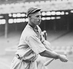
 Bubbles Hargrave in 1914.
- Lloy Ball, professional volleyball player, Olympic gold medalist, 2008 Summer Olympics
- David Doster, former player for MLB Philadelphia Phillies
- Norm Ellenberger, former head coach of the University of New Mexico Lobos and assistant coach to the NBA Chicago Bulls
- Bubbles Hargrave, former player for MLB Chicago Cubs, Cincinnati Reds, and New York Yankees
- Pinky Hargrave, former player for MLB Washington Senators, St. Louis Browns, Detroit Tigers, and Boston Braves
References
- ^ a b "American FactFinder". United States Census Bureau. http://factfinder.census.gov. Retrieved 2008-01-31.
- ^ "US Board on Geographic Names". United States Geological Survey. 2007-10-25. http://geonames.usgs.gov. Retrieved 2008-01-31.
- ^ "US Gazetteer files: 2010, 2000, and 1990". United States Census Bureau. 2011-02-12. http://www.census.gov/geo/www/gazetteer/gazette.html. Retrieved 2011-04-23.
- ^ "Monthly Averages for New Haven, IN". The Weather Channel. http://www.weather.com/outlook/recreation/golf/wxclimatology/monthly/USIN0465. Retrieved 2009-02-14.
- ^ "Leading Employers In Allen County". Fort Wayne - Allen County Economic Development Alliance. 2008. http://www.theallianceonline.com/top_employers.aspx. Retrieved 2009-02-14.
External links
- City of New Haven, Indiana website
- Maumee Valley Heritage Corridor
- Fort Wayne Railroad Historical Society
Municipalities and communities of Allen County, Indiana Cities Fort Wayne | New Haven | Woodburn

Towns Grabill | Huntertown | Leo-Cedarville | Monroeville | Zanesville‡
Townships Aboite | Adams | Cedar Creek | Eel River | Jackson | Jefferson | Lafayette | Lake | Madison | Marion | Maumee | Milan | Monroe | Perry | Pleasant | Saint Joseph | Scipio | Springfield | Washington | Wayne
Unincorporated
communitiesAboite | Arcola | Ari | Boston Corner | Cedar Canyons | Cedar Shores | Cuba | Dunn Mill | East Liberty | Edgerton | Five Points | Four Presidents Corners | Halls Corners | Harlan | Hessen Cassel | Hoagland | Lake Everett | Maples | Milan Center | Poe | Sunnymede Woods | Tillman | Timbercrest | Townley | Yoder | Zulu
Footnotes ‡This populated place also has portions in an adjacent county or counties
Counties 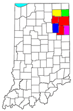
Municipalities with population
over 10,000 in 2000Municipalities with population
1,000-10,000 in 2000Albion · Andrews · Ashley · Avilla · Berne · Bluffton · Butler · Churubusco · Columbia City · Decatur · Garrett · Geneva · Grabill · Hamilton · Harlan · Huntertown · Kendallville · Leo-Cedarville · Ligonier · Markle · Monroeville · Ossian · Roanoke · Rome City · South Whitley · Warren · Waterloo · WoodburnMunicipalities with population
under 1,000 in 2000Altona · Cromwell · Corunna · Monroe · Mount Etna · Larwill · Poneto · Saint Joe · Uniondale · Vera Cruz · Wolcottville · ZanesvilleCategories:- Cities in Indiana
- Populated places in Allen County, Indiana
- Fort Wayne metropolitan area
- Populated places established in 1865


Wikimedia Foundation. 2010.