- Ossian, Indiana
-
Town of Ossian, Indiana — Town — Location of Ossian in the state of Indiana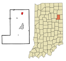
Coordinates: 40°52′50″N 85°10′6″W / 40.88056°N 85.16833°WCoordinates: 40°52′50″N 85°10′6″W / 40.88056°N 85.16833°W Country United States State Indiana County Wells Township Jefferson Area – Total 1.5 sq mi (3.9 km2) – Land 1.5 sq mi (3.9 km2) – Water 0.0 sq mi (0.0 km2) Elevation 797 ft (256 m) Population (2010) – Total 3,289 – Density 1,972.0/sq mi (761.4/km2) Time zone Eastern (EST) (UTC-5) – Summer (DST) EDT (UTC-4) ZIP code 46777 Area code(s) 260 FIPS code 18-57168[1] GNIS feature ID 0440726[2] Website http://www.ossianin.com/ Ossian is a town in Jefferson Township, Wells County, Indiana, United States. The population was 3,289 at the 2000 census.
Contents
Geography
Ossian is located at 40°52′50″N 85°10′6″W / 40.88056°N 85.16833°W (40.880447, -85.168369)[3].
According to the United States Census Bureau, the town has a total area of 1.5 square miles (3.9 km2), all of it land.
Demographics
As of the census[1] of 2000, there were 2,943 people, 1,130 households, and 807 families residing in the town. The population density was 1,972.0 people per square mile (762.6/km²). There were 1,168 housing units at an average density of 782.6 per square mile (302.7/km²). The racial makeup of the town was 98.44% White, 0.14% African American, 0.10% Native American, 0.14% Asian, 0.44% from other races, and 0.75% from two or more races. Hispanic or Latino of any race were 1.16% of the population.
There were 1,130 households out of which 38.3% had children under the age of 18 living with them, 57.9% were married couples living together, 10.4% had a female householder with no husband present, and 28.5% were non-families. 25.0% of all households were made up of individuals and 11.1% had someone living alone who was 65 years of age or older. The average household size was 2.54 and the average family size was 3.04.
In the town the population was spread out with 28.4% under the age of 18, 7.9% from 18 to 24, 29.8% from 25 to 44, 18.9% from 45 to 64, and 14.9% who were 65 years of age or older. The median age was 35 years. For every 100 females there were 91.7 males. For every 100 females age 18 and over, there were 84.4 males.
The median income for a household in the town was $45,449, and the median income for a family was $54,188. Males had a median income of $36,875 versus $25,682 for females. The per capita income for the town was $18,925. About 3.0% of families and 4.4% of the population were below the poverty line, including 4.2% of those under age 18 and 11.0% of those age 65 or over.
History
In 1843, Indiana State Road 1 was made serviceable from Fort Wayne to Bluffton. On January 25, 1850, the Fort Wayne and Bluffton Plank Road Company was then organized. The plank road was a toll road; any horse or horse-drawn vehicle had to pay a toll. The Fort Wayne, Cincinnati, & Louisville Railroad was built through Ossian in 1869, though it was not in complete operation until the following year. Today, the railroad is a significant north-south route for the Norfolk Southern Corporation. Ossian is still served by Indiana State Road 1, while four miles north is Interstate 469, the beltway around Fort Wayne, and also just seven miles south of Fort Wayne International Airport.
Economy
Ossian has always been an industrial town. The businesses of yesterday have given way to modern establishments in recent decades. The town industrial park is home to engineering and manufacturing companies producing materials such as tool and die, plastic gas tanks, and import of bath fixtures, just to name a few. Ossian is also surrounded by agriculture, the most important piece of Indiana's economy.
School District
Northern Wells Community Schools serves northern Wells County, including the town of Ossian. The district operates four schools; Ossian Elementary, Lancaster Elementary, Norwell Middle School, and Norwell High School. It also operates a private school called Bethlehem Lutheran School which can be found a few miles Southeast of town.
References
- ^ a b "American FactFinder". United States Census Bureau. http://factfinder.census.gov. Retrieved 2008-01-31.
- ^ "US Board on Geographic Names". United States Geological Survey. 2007-10-25. http://geonames.usgs.gov. Retrieved 2008-01-31.
- ^ "US Gazetteer files: 2010, 2000, and 1990". United States Census Bureau. 2011-02-12. http://www.census.gov/geo/www/gazetteer/gazette.html. Retrieved 2011-04-23.
External links
- Town of Ossian, Indiana website
- Ossian News http://www.news-banner.com/
- School District Website http://www.nwcs.k12.in.us/
Municipalities and communities of Wells County, Indiana City 
Towns Markle‡ | Ossian | Poneto | Uniondale | Vera Cruz | Zanesville‡
Townships Unincorporated
communitiesCraigville | Curryville | Dillman | Domestic | Five Points | Greenville | Greenwood | Jeff | Keystone | Kingsland | Liberty Center | McNatts | Mount Zion | Murray | North Oaks | Nottingham | Petroleum | Phenix | Reiffsburg | Riverside | Rockford | Tocsin | Toll Gate Heights | Travisville | Wellsburg
Footnotes ‡This populated place also has portions in an adjacent county or counties
Counties 
Municipalities with population
over 10,000 in 2000Municipalities with population
1,000-10,000 in 2000Albion · Andrews · Ashley · Avilla · Berne · Bluffton · Butler · Churubusco · Columbia City · Decatur · Garrett · Geneva · Grabill · Hamilton · Harlan · Huntertown · Kendallville · Leo-Cedarville · Ligonier · Markle · Monroeville · Ossian · Roanoke · Rome City · South Whitley · Warren · Waterloo · WoodburnMunicipalities with population
under 1,000 in 2000Altona · Cromwell · Corunna · Monroe · Mount Etna · Larwill · Poneto · Saint Joe · Uniondale · Vera Cruz · Wolcottville · ZanesvilleCategories:- Populated places in Wells County, Indiana
- Towns in Indiana
- Fort Wayne metropolitan area


Wikimedia Foundation. 2010.