- Makawao, Hawaii
-
Makawao, Hawaii — CDP — Looking up on Baldwin Avenue towards the Baldwin Ave/Makawao Ave/Olinda Road Intersection.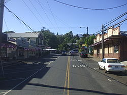 Location in Maui County and the state of Hawaii
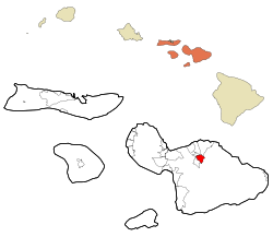
Coordinates: 20°51′13″N 156°19′1″W / 20.85361°N 156.31694°WCoordinates: 20°51′13″N 156°19′1″W / 20.85361°N 156.31694°W Country United States State Hawaii County Maui Area - Total 4.7 sq mi (12.1 km2) - Land 4.7 sq mi (12.1 km2) - Water 0.0 sq mi (0.0 km2) Elevation 1,578 ft (481 m) Population (2000) - Total 6,327 - Density 1,353.8/sq mi (522.7/km2) Time zone Hawaii-Aleutian (UTC-10) ZIP code 96768 Area code(s) 808 FIPS code 15-48050 GNIS feature ID 0362090 Makawao is a census-designated place (CDP) in Maui County, Hawaiʻi, United States. The population was 6,327 at the 2000 census. Located in the rural northeast slope of Haleakala on East Maui, the community is known for being the hub of the "Upcountry", a part of the island dominated by mostly agriculture and ranch land.
Contents
Geography
Makawao is located at 20°51′13″N 156°19′1″W / 20.85361°N 156.31694°W (20.853657, -156.316951)[1].
According to the United States Census Bureau, the CDP has a total area of 4.7 square miles (12 km2), all of it land.
Demographics
As of the census of 2000,[2] there were 6,327 people, 2,151 households, and 1,565 families residing in the CDP. The population density was 1,353.8 people per square mile (523.1/km²). There were 2,222 housing units at an average density of 475.5 per square mile (183.7/km²). The racial makeup of the CDP was 40.54% White, 0.32% African American, 0.55% Native American, 17.04% Asian, 8.74% Pacific Islander, 1.56% from other races, and 31.25% from two or more races. Hispanic or Latino of any race were 11.93% of the population.
There were 2,151 households out of which 41.4% had children under the age of 18 living with them, 51.7% were married couples living together, 14.8% had a female householder with no husband present, and 27.2% were non-families. 17.6% of all households were made up of individuals and 4.6% had someone living alone who was 65 years of age or older. The average household size was 2.94 and the average family size was 3.34.
In the CDP the population was spread out with 29.6% under the age of 18, 7.9% from 18 to 24, 32.0% from 25 to 44, 23.4% from 45 to 64, and 7.2% who were 65 years of age or older. The median age was 35 years. For every 100 females there were 99.5 males. For every 100 females age 18 and over, there were 93.2 males.
The median income for a household in the CDP was $46,681, and the median income for a family was $50,145. Males had a median income of $32,917 versus $26,955 for females. The per capita income for the CDP was $18,776. About 7.4% of families and 9.6% of the population were below the poverty line, including 10.7% of those under age 18 and 9.7% of those age 65 or over.
References
- ^ "US Gazetteer files: 2010, 2000, and 1990". United States Census Bureau. 2011-02-12. http://www.census.gov/geo/www/gazetteer/gazette.html. Retrieved 2011-04-23.
- ^ "American FactFinder". United States Census Bureau. http://factfinder.census.gov. Retrieved 2008-01-31.
External links
 State of Hawaii
Honolulu (capital) Topics Geography · Government · Delegations · History · Islands · Music · Language · People · Visitor Attractions
Society Main Islands Northwestern
IslandsFrench Frigate Shoals · Gardner · Kure · Laysan · Lisianski · Maro Reef · Necker · Nihoa · Pearl and Hermes
Communities Counties Municipalities and communities of Maui County, Hawaii County seat: Wailuku CDPs Haiku-Pauwela | Haliimaile | Hana | Kaanapali | Kahului | Kapalua | Kaunakakai | Kihei | Kualapuu | Lahaina | Lanai City | Maalaea | Makawao | Maunaloa | Napili-Honokowai | Paia | Pukalani | Waihee-Waiehu | Waikapu | Wailea-Makena | Wailuku

Unincorporated
communitiesCategories:- Census-designated places in Maui County, Hawaii
- Populated places on Maui


Wikimedia Foundation. 2010.