- Mansfield Hollow Lake
-
Mansfield Hollow Lake 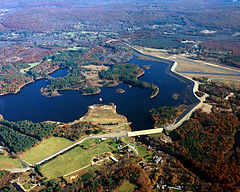
Aerial view. Windham Airport can be seen at the right. Location Border of Windham and Tolland County, Connecticut Coordinates 41°45′21″N 72°10′52″W / 41.75583°N 72.18111°WCoordinates: 41°45′21″N 72°10′52″W / 41.75583°N 72.18111°W[1] Lake type reservoir Primary inflows Natchaug River, Fenton River, Mount Hope River Primary outflows Natchaug River Basin countries United States Surface area 440 acres (180 ha)[2] Max. depth 23 ft (7.0 m)[2] Water volume 2,260,000,000 cu ft (0.064 km3)[3] Surface elevation 256 ft (78 m)[1] Settlements Mansfield and Willimantic References [1][2][3] Mansfield Hollow Lake Official name Mansfield Hollow Dam Location Mansfield and Windham, Connecticut Construction began 1949 Opening date 1952 Dam and spillways Height 68 ft (21 m) Length 12,420 ft (3,790 m) Base width 265 ft (81 m) Impounds Natchaug River Reservoir Creates Lake Naubesatuck Mansfield Hollow Lake is a reservoir resting on the border of Windham County and Tolland County, Connecticut. It was created by the Mansfield Hollow Dam and is entirely contained within Mansfield Hollow State Park. Designed and constructed by the United States Army Corps of Engineers, this dam substantially reduces flooding along the Quinebaug, Shetucket, and Thames rivers. Construction of the project began in 1949 with completion in 1952 at a cost of US$6.5 million. The Mansfield Hollow reservoir is located within the Shetucket River Watershed and is part of the Thames River Basin. Access to the site is available from US Route 6 and State Route 195 .
Contents
Description
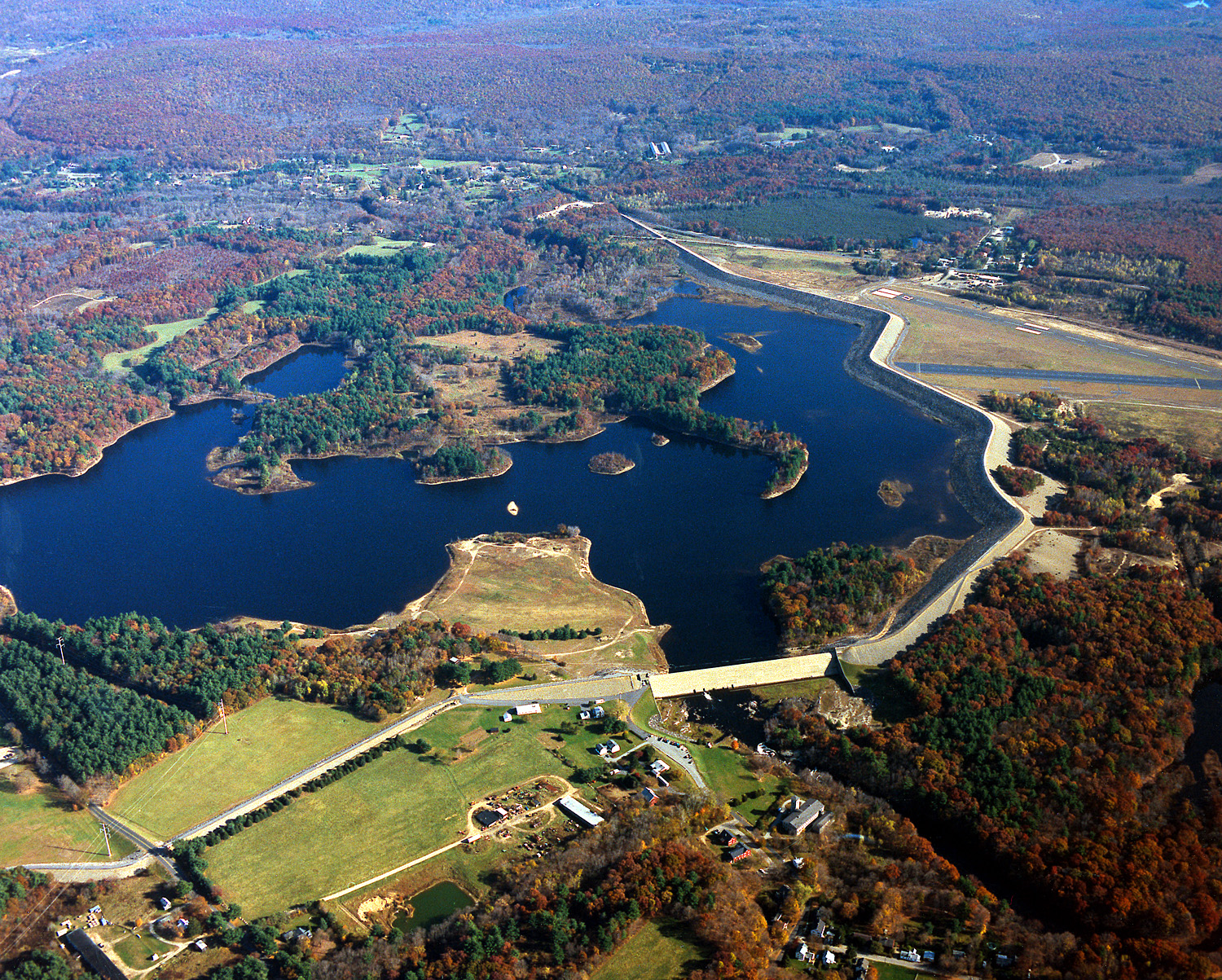
The project consists of a rolled earth fill dam with stone slope protection 12,420 feet (3,790 m) long and 68 feet (21 m) high. The spillway comprises a concrete weir 690 ft (210 m) in length. The weir's crest elevation is 16 feet (4.9 m) lower than the top of the dam. The permanent lake at Mansfield Hollow Dam, Naubesatuck Lake is 450 acres (1.8 km2) in size. The flood storage area for the entire project covers about 1,880 acres (7.6 km2) in the towns of Mansfield, Windham, and Chaplin, Connecticut. The entire project, including all associated lands, covers 2,472 acres (10.00 km2). The Mansfield Hollow Dam can store up to 16.1 billion US gallons (61,000,000 m3) of water for flood control purposes. This is equivalent to 5.8 inches (150 mm) of water runoff from its drainage area of 159 square miles (410 km2).
Recreation
Mansfield Hollow State Park is located on Bassett Bridge Road in the town of Mansfield. It offers a shaded picnic area and many miles of hiking and cross country ski trails. This recreation area is open daily from sunrise to sunset. There is no entrance fee. This area is managed by the State of Connecticut Department of Environmental Protection.
Mansfield Hollow Dam is located on Mansfield Hollow Road in the town of Mansfield. Here, visitors can picnic on the lawn both downstream of the dam and on the lake side of the dam. The construction of the dam began in 1949 and completed in 1952 at a cost of $6.5 million by the U.S. Army Corps of Engineers. The damsite, covering an area of 25 acres (10 ha), was listed on the National Register of Historic Places in 2003.[4] This dam, which created Mansfield Hollow Lake, substantially reduces flooding along the Quinebaug, Shetucket, and Thames rivers.
The Mansfield Hollow reservoir is located within the Shetucket River Watershed and is part of the Thames River Basin. Access to the site is available from US Route 6 and State Route 195. The top of the dam itself is popular for walking, jogging, and biking. The west half of the dam is approx. 1-mile (1.6 km) long, the east half is almost 2 miles (3.2 km) long. Parking is available at the State Park, Damsite, Commuter Parking Lot on US Route 6, and athletic field parking lot on State Route 89. A boat launch is located on Bassett Bridge Road in the town of Mansfield, 1/2 mile east of the State Park entrance. The dam runs alongside Windham Airport.
References
- ^ a b c U.S. Geological Survey Geographic Names Information System: Mansfield Hollow Lake
- ^ a b c Connecticut Department of Environmental Protection (2004). "Mansfield Hollow Lake". Archived from the original on 2006-05-20. http://web.archive.org/web/20060520061417/http://www.dep.state.ct.us/cgnhs/lakes/mhollow/lake.htm.
- ^ a b United States Geological Survey (2005). "Water Resources Data Connecticut Water Year 2005". p. 82. http://pubs.usgs.gov/wdr/2005/wdr-ct-05-1/. Retrieved 2007-06-04.
- ^ "NRHP Inventory-Nomination: Mansfield Hollow Dam". National Park Service. http://pdfhost.focus.nps.gov/docs/NRHP/Text/03000194.pdf.
External links
Protected areas of Connecticut National Park Service National Wildlife Refuges Silvio O. Conte • Stewart B. McKinney National Wildlife Refuge
National Trails State Parks Airline • Beckley Iron Furnace Industrial Monument • Bigelow Hollow • Black Rock • Bluff Point • Burr Pond • Camp Columbia • Campbell Falls • Chatfield Hollow • Collis P. Huntington • Connecticut Valley Railroad • Day Pond • Dennis Hill • Devil's Hopyard • Dinosaur • Fort Griswold Battlefield • Fort Trumbull • Gardner Lake • Gay City • George W. Seymour • Gillette Castle • Haddam Meadows • Haley Farm • Hammonasset Beach • Hampton Beach • Harkness Memorial • Haystack Mountain • Hop River State Park Trail • Hopeville Pond • Housatonic Meadows • Hurd • Indian Well • John A. Minetto • Kent Falls • Kettletown • Lake Waramaug • Larkin State Park Trail • Levy • Lovers Leap • Macedonia Brook • Mansfield Hollow • Mashamoquet Brook • Millers Pond • Mohawk Mountain • Moosup Valley State Park Trail • Mount Tom • Old Furnace • Osbornedale • Penwood • Putnam Memorial • Quaddick • Quinnipiac River • River Highlands • Rocky Neck • Selden Neck • Seth Low Pierrepont • Sherwood Island • Silver Sands • Sleeping Giant • Southford Falls • Squantz Pond • Stratton Brook • Talcott Mountain • Wadsworth Falls • West Rock Ridge • Wharton Brook • Windsor Locks Canal State Park Trail
State Forests Algonquin • American Legion • Centennial Watershed • Cockaponset • Enders • James L. Goodwin • Housatonic • Massacoe • Mattatuck • Meshomasic • Mohawk • Mohegan • Nassahegon • Natchaug • Nathan Hale • Nehantic • Nepaug • Nipmuck • Nye-Holman • Pachaug • Paugnut • People's • Pootatuck • Quaddick • Salmon River • Shenipsit • Topsmead • Tunxis • Wyantenock
Connecticut Department of Environmental Protection (web)U.S. National Register of Historic Places in Connecticut Lists by county 
Lists by city Bridgeport • Greenwich • Hartford • Middletown • New Haven • Southington • Stamford • West Hartford • WindsorOther lists Categories:- Mansfield, Connecticut
- Reservoirs in Connecticut
- Willimantic, Connecticut
- Landforms of Windham County, Connecticut
- Landforms of Tolland County, Connecticut
- Windham, Connecticut
- Protected areas established in 1952
- Dams in Connecticut
- Dams on the National Register of Historic Places
- National Register of Historic Places in Connecticut
- Buildings and structures in Tolland County, Connecticut
- Buildings and structures completed in 1952


Wikimedia Foundation. 2010.