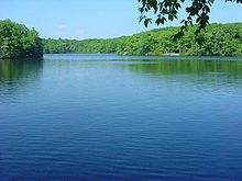
- Millers Pond State Park
-
Coordinates: 41°28′35″N 72°38′0″W / 41.47639°N 72.633333°W
Millers Pond State Park is located off Foothills Road in Durham, Connecticut. The state park consists of 30 acres (12 ha) of pond and 170 acres (69 ha) of woodlands. Here, many residents and guests enjoy leisure activities such as fishing, hiking, mountain biking, and hunting. Miller's Pond gets its source of water from large springs, making great conditions to fish for trout and smallmouth bass.
History
Millers Pond was acquired in 1955 by the State Park and Forest Commission from the heirs of Thomas Macdonough Russell with monies provided in the trust fund of George Dudley Seymour. Thomas Miller was the person who erected the upper dam in 1704 to make a reservoir for his gristmill that was located further downstream. In succeeding years, the state purchased additional property, completing acquisition of all the land around the pond in 1972. Millers Pond is unique in that its principal source of water comes from large springs which create a body of unpolluted water excellent for smallmouth bass or trout.
References
External links
Protected areas of Connecticut National Park Service National Wildlife Refuges Silvio O. Conte • Stewart B. McKinney National Wildlife Refuge
National Trails State Parks Airline • Beckley Iron Furnace Industrial Monument • Bigelow Hollow • Black Rock • Bluff Point • Burr Pond • Camp Columbia • Campbell Falls • Chatfield Hollow • Collis P. Huntington • Connecticut Valley Railroad • Day Pond • Dennis Hill • Devil's Hopyard • Dinosaur • Fort Griswold Battlefield • Fort Trumbull • Gardner Lake • Gay City • George W. Seymour • Gillette Castle • Haddam Meadows • Haley Farm • Hammonasset Beach • Hampton Beach • Harkness Memorial • Haystack Mountain • Hop River State Park Trail • Hopeville Pond • Housatonic Meadows • Hurd • Indian Well • John A. Minetto • Kent Falls • Kettletown • Lake Waramaug • Larkin State Park Trail • Levy • Lovers Leap • Macedonia Brook • Mansfield Hollow • Mashamoquet Brook • Millers Pond • Mohawk Mountain • Moosup Valley State Park Trail • Mount Tom • Old Furnace • Osbornedale • Penwood • Putnam Memorial • Quaddick • Quinnipiac River • River Highlands • Rocky Neck • Selden Neck • Seth Low Pierrepont • Sherwood Island • Silver Sands • Sleeping Giant • Southford Falls • Squantz Pond • Stratton Brook • Talcott Mountain • Wadsworth Falls • West Rock Ridge • Wharton Brook • Windsor Locks Canal State Park Trail
State Forests Algonquin • American Legion • Centennial Watershed • Cockaponset • Enders • James L. Goodwin • Housatonic • Massacoe • Mattatuck • Meshomasic • Mohawk • Mohegan • Nassahegon • Natchaug • Nathan Hale • Nehantic • Nepaug • Nipmuck • Nye-Holman • Pachaug • Paugnut • People's • Pootatuck • Quaddick • Salmon River • Shenipsit • Topsmead • Tunxis • Wyantenock
Connecticut Department of Environmental Protection (web)Categories:- Durham, Connecticut
- Connecticut state parks
- Ponds of Connecticut
- Parks in Middlesex County, Connecticut
- Protected areas established in 1955
- Connecticut geography stubs
Wikimedia Foundation. 2010.

