- Natchaug State Forest
-
Coordinates: 41°59′56″N 72°07′55″W / 41.999°N 72.132°W
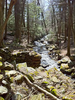 Remains of old mill dam on Beaverdam Brook off Natchaug Trail.
Natchaug State Forest, in Ashford, Connecticut, Chaplin, Connecticut and Eastford, Connecticut is a Connecticut State Forest. It's 13,000 acres (53 km2) are part of a larger network of forest lands making up some 40,000 acres (160 km2) in all[1]. The Natchaug River runs from North to South along (and in a few cases through) the western border of the main forest parcel.
Contents
Environment
The Forest lies within the Northeastern coastal forests ecoregion[2].
Recreation opportunities
Hiking is available through an extensive network of trails including the CCC Loop and Natchaug Trail.
Horseback riding is popular in the forest with several facilities, including a campground, geared toward equestrians.
Camping is allowed in the back country of the forest and in one established campground for horses.
See also
- Natchaug River
- Natchaug Trail
- Quinebaug and Shetucket Rivers Valley National Heritage Corridor
- List of Connecticut state forests
External links
References
- ^ "CT DEP site on Natchaug State Forest". CT DEP. http://www.ct.gov/Dep/cwp/view.asp?A=2716&Q=325062. Retrieved 2009-06-18.
- ^ Olson, D. M, E. Dinerstein, et al (2001). "Terrestrial Ecoregions of the World: A New Map of Life on Earth". BioScience 51 (11): 933–938. doi:10.1641/0006-3568(2001)051[0933:TEOTWA]2.0.CO;2. http://gis.wwfus.org/wildfinder/.
Protected areas of Connecticut National Park Service National Wildlife Refuges Silvio O. Conte • Stewart B. McKinney National Wildlife Refuge
National Trails State Parks Airline • Beckley Iron Furnace Industrial Monument • Bigelow Hollow • Black Rock • Bluff Point • Burr Pond • Camp Columbia • Campbell Falls • Chatfield Hollow • Collis P. Huntington • Connecticut Valley Railroad • Day Pond • Dennis Hill • Devil's Hopyard • Dinosaur • Fort Griswold Battlefield • Fort Trumbull • Gardner Lake • Gay City • George W. Seymour • Gillette Castle • Haddam Meadows • Haley Farm • Hammonasset Beach • Hampton Beach • Harkness Memorial • Haystack Mountain • Hop River State Park Trail • Hopeville Pond • Housatonic Meadows • Hurd • Indian Well • John A. Minetto • Kent Falls • Kettletown • Lake Waramaug • Larkin State Park Trail • Levy • Lovers Leap • Macedonia Brook • Mansfield Hollow • Mashamoquet Brook • Millers Pond • Mohawk Mountain • Moosup Valley State Park Trail • Mount Tom • Old Furnace • Osbornedale • Penwood • Putnam Memorial • Quaddick • Quinnipiac River • River Highlands • Rocky Neck • Selden Neck • Seth Low Pierrepont • Sherwood Island • Silver Sands • Sleeping Giant • Southford Falls • Squantz Pond • Stratton Brook • Talcott Mountain • Wadsworth Falls • West Rock Ridge • Wharton Brook • Windsor Locks Canal State Park Trail
State Forests Algonquin • American Legion • Centennial Watershed • Cockaponset • Enders • James L. Goodwin • Housatonic • Massacoe • Mattatuck • Meshomasic • Mohawk • Mohegan • Nassahegon • Natchaug • Nathan Hale • Nehantic • Nepaug • Nipmuck • Nye-Holman • Pachaug • Paugnut • People's • Pootatuck • Quaddick • Salmon River • Shenipsit • Topsmead • Tunxis • Wyantenock
Connecticut Department of Environmental Protection (web) Hiking Trails in Connecticut Airline State Park Trail • Alain and May White Trails • American Legion • Appalachian Trail • Aspetuck Valley • Bigelow Hollow • Case Mountain • Charter Oak Greenway • Chatfield • Cockaponset • East Coast Greenway • Falls Brook • Farmington Canal Heritage Trail • Gay City • Hancock Brook • Hop River State Park Trail • Housatonic Range • Jericho • Kettletown • Lillinonah • Lone Pine • Macedonia Brook • Mattabesett • Mattatuck • McLean Game Refuge • Menunkatuck • Metacomet • Mohawk • Moosup Valley State Park Trail • Muir • Narragansett • Natchaug • Naugatuck • Nayantaquit • Nehantic • New England National Scenic Trail • Nipmuck • Old Furnace • Patchaug • Paugussett • Peoples • Pequot • Pine Knob • Pomperaug • Quinebaug • Quinnipiac • Ragged Mountain • Regicides • Salmon River • Saugatuck • Shenipsit • Sleeping Giant • Sleeping Giant State Park • Stony Creek Quarry • Sunny Valley Preserve • Tunxis • Washington–Rochambeau Revolutionary Route • Westwoods • Whitestone Cliffs • Wolcott Trail • Zoar
 Categories:
- Connecticut state forests
- Parks in Tolland County, Connecticut
- Connecticut geography stubs


Wikimedia Foundation. 2010.