- Mattabesett Trail
-
Mattabesett Trail 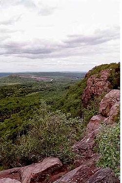
Higby Mountain along the Mattabesett Trail Length 50.0 miles (80.5 km) [1] Location Connecticut Designation National Scenic Trail, CFPA Blue-Blazed Trail Trailheads Start: River Road in Middletown, opposite power plant on Connecticut River.
End: Berlin Turnpike in Berlin.Use hiking, cross-country skiing, snowshoeing, fishing, geocaching, other Highest point Higby Mountain north summit
892 ft (272 m)Lowest point Connecticut River, Middletown
18 ft (5.5 m)Trail difficulty Easy to difficult with a few dangerous ridge walk sections Hazards hunters, deer ticks, poison ivy The Mattabesett Trail is a 50-mile (80 km) long, hook-shaped Blue-Blazed hiking trail in central Connecticut and a part of the newly designated 'New England National Scenic Trail'. One half of the trail follows the high traprock ridges of the Metacomet Ridge, from Totoket Mountain in Guilford, Connecticut to Lamentation Mountain in Meriden, Connecticut from south to north. This ridge is known for its biodiversity, miles of scenic cliffs, and rugged hiking. The second half of the trail extends north from Guilford to Middletown, Connecticut and ends at the Connecticut River. Here, the trail follows an upland of metamorphic rock with occasional views and dense forests.
Important features along the trail include Lamentation Mountain, Chauncey Peak, Higby Mountain, Besek Mountain, Fowler Mountain, Trimountain, Pistapaug Mountain, Totoket Mountain, the Broomstick Ledges, Seven Falls, and Coginchaug Cave. The Metacomet Trail continues north from Lamentation Mountain where the Mattabesett Trail leaves off.
The geology, ecology, and landscape of the trail are similar to that of the Metacomet-Monadnock Trail to the north in Massachusetts.
In 2000, the United States Congress authorized the National Park Service to research a new National Scenic Trail now tentatively called the New England National Scenic Trail in southern New England, which would include the Mattabesett Trail as well as the Metacomet-Monadnock Trail and the Metacomet Trail.
On March 30, 2009 President Barack Obama signed the 'Omnibus Public Land Management Act of 2009' establishing the New England National Scenic Trail (and two other national scenic trails).[2]
The combination of the Metacomet, Monadnock and Mattabesett trails is also often referred to as the '3-M', 'MMM' or Metacomet-Monadnock-Mattabesett trail. The New England National Scenic Trail will eventually include all or almost all of the 'MMM' trails as well as a proposed extension trail from the southern-most point on the Mattabesett Trail through Guilford, Connecticut to the northern shore of Long Island Sound.[3]
Contents
Trail description
The southern-western terminus of the trail is located on the eastern side of the state road known as Connecticut Route 5 and Route 15 across the road from the trailhead for the Metacomet Trail.
The Mattabesett Trail is primarily used for hiking, backpacking, picnicking, and in the winter, snowshoeing.
Portions of the trail are suitable for, and are used for, cross-country skiing and geocaching. Site-specific activities enjoyed along the route include bird watching, hunting, fishing, horseback riding, bouldering and rock climbing.
Trail route
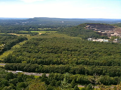 View from Higby Mountain of Interstate 91 and the eastern quarry face of Chauncey Peak. In the far distance is Lamentation Mountain's long ridge.
Trail communities
The official Blue-Blazed Mattabesett Trail passes through land located within the following Connecticut municipalities, from northwest to south then northeast: Berlin, Middletown, Meriden, Middletown, Meriden, Middlefield, Wallingford, Connecticut, Durham, Connecticut, Wallingford, Connecticut, Durham, Connecticut, North Branford, Guilford, Madison, Durham, Haddam, Middletown.
Landscape, geology, and natural environment
History and folklore
The Blue-Blazed Mattabesett Trail was the third trail created by the Connecticut Forest and Park Association and was completed in 1932. Students from Wesleyan University helped to clear and blaze the trail.
The rough route of the original trail blazed in the 1930s can be seen in the Connecticut Forest and Park Association's 1940 Connecticut Walk Book map of major trails.[4]
Origin and name
The trail is named for the Mattabesett (alternate forms Mattabeseck, Mattabesick and Metewemesick—as written by Roger Williams ) river and native American tribe (also known as "Black-hill Indians") that inhabited the Middletown area.
Mattabesett was also the original name for Middletown at the time European settlers arrived. The derivation Mete-wis translates to "black earth".[5]
For more information on the Mattabesset tribe of native-Americans ("American Indians") see the Wikipedia entry on the Mattabesset.
Historic sites
The following historic sites can be found on the Mattabesett Trail route:
- The abandoned Powder Ridge Ski area ski lifts and slopes.
- Several colonial area stagecoach roads including Stagecoach Road and Wadsworth Farm Road (which George Washington is alleged to have used in 1775 and 1789).
- Myerhuber Pond -- excavated by farmer Conrad Myerhuber using a team of oxen.
- The Selectman's Stones border marker at the corners of Durham, Guilford and Madison.
- The Pest House cellar ruins off of the Mica Ledges in Durham.
Folklore
Hiking the trail
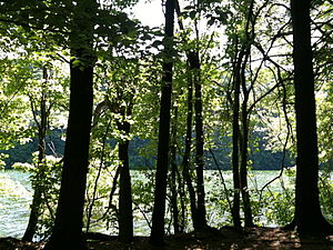 Crescent Lake (Bradley Hubbard Reservoir) in Meriden's Giuffrida Park on the Mattabesett Trail. .
The mainline trail is blazed with blue rectangles. Trail descriptions are available from a number of commercial and non-commercial sources, and a complete guidebook is published by the Connecticut Forest and Park Association
It is regularly maintained, and is considered moderately challenging due to the amount of elevation change with sections of rugged and moderately difficult hiking. As there are dangerous ridge walks children should be supervised in the eastern section's heights.
Much of the trail is close to public roads. There are no camping facilities along the trail and camping is generally prohibited in the areas along the trail.
Weather along the route is typical of Connecticut. Conditions on exposed ridge tops and summits may be harsher during cold or stormy weather.[6] Lightning is a hazard on exposed summits and ledges during thunderstorms. Snow is common in the winter and may necessitate the use of snowshoes. Ice can form on exposed ledges and summits, making hiking dangerous without special equipment.
Extensive flooding in ponds, puddles and streams may occur in the late winter or early spring, overflowing into the trail and causing very muddy conditions. In this case fairly high waterproof boots are recommended. Some southern and eastern parts of the trail follow forest roads which often contain ruts from ATVs and four-wheel drive vehicles.
Biting insects can be bothersome during warm weather. Parasitic deer ticks (which are known to carry Lyme disease) are a potential hazard.
Parts of the trail (particularly the easternmost sections) are adjacent to, or is on lands where hunting and the use of firearms are permitted. Wearing bright orange clothing during the hunting season (Fall through December) is recommended.
Conservation and maintenance of the trail corridor
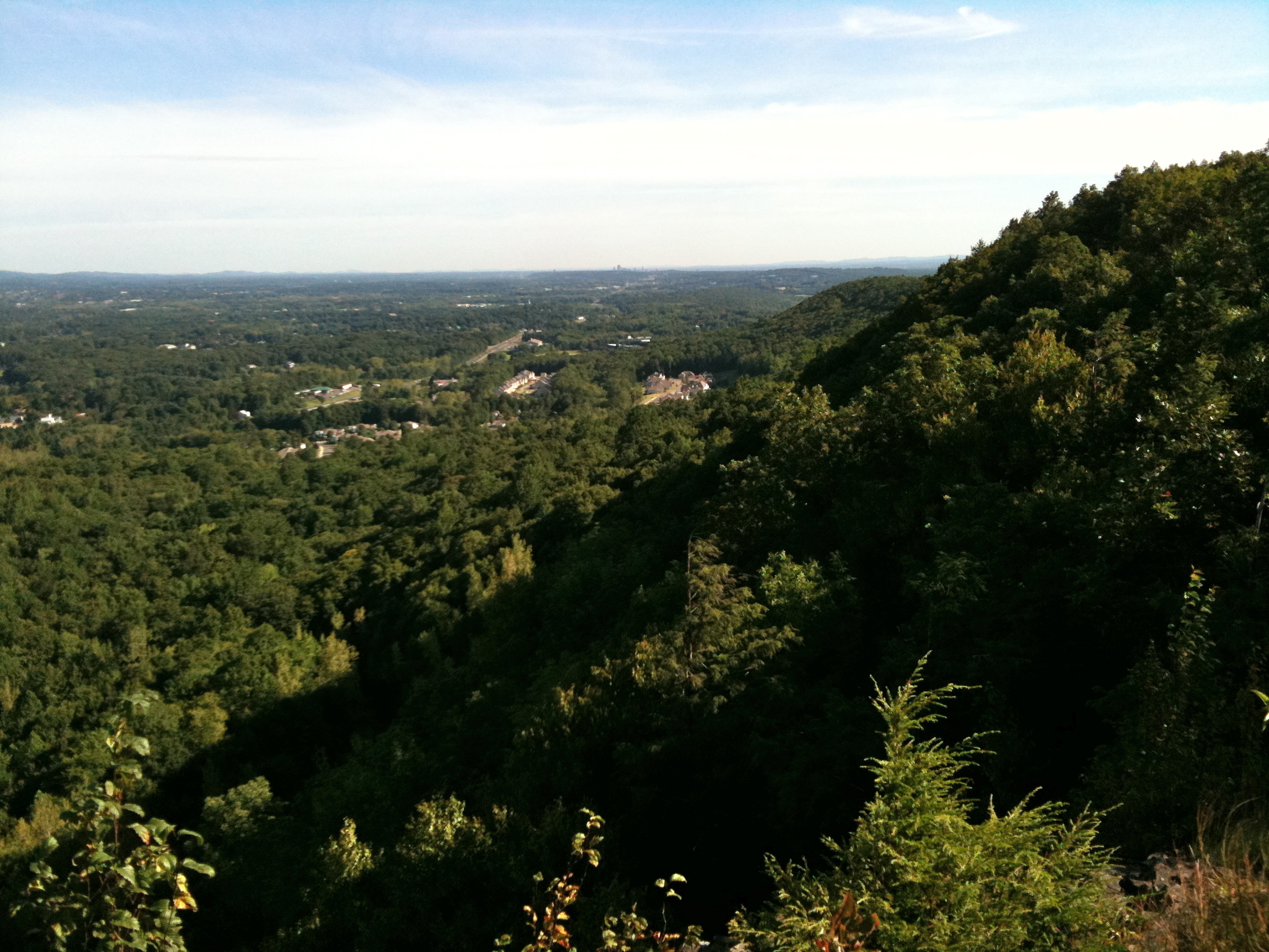
 Looking north at Lamentation Mountain from the Lamentation Mountain ridge.
Recognition / Inspiration Programs
The Connecticut Forest and Park Association (CFPA) provides commemorative patches as recognition to hikers completing the entire length of one of the three original Blue-Blazed trails in Connecticut (Quinnipiac, Metacomet and Mattabesett). The Mattabesett Trail patch can be obtained for a small fee ($1) after the hiking the entire trail is completed by contacting the Connecticut Forest and Park Association.
This trail system is a part of the 'Connecticut 400', one of the official Blue-Blazed (or similar) trails listed in the Connecticut Walk Book by the Connecticut Forest and Park Association (CFPA) and recognized, since 1976, with an award known as the Connecticut 400 Club by the Connecticut Chapter of the Appalachian Mountain Club (AMC). In 1976 there were only four hundred miles of Blue-Blazed trail but today (2010) the total length of the trails listed in the CFPA Connecticut Walk Books (East and West) exceeds 825 miles.[7][8][9]
The State of Connecticut Department of Environmental Protection (CT DEP) Forestry Division provides two awards for locating and visiting "letterboxes" (similar to geocaches) in Connecticut's State Forests. The commemorative 'State Forest Centennial Patch' is available to those who complete five sponsored "letterbox" hikes (in each separate state forest you must hike the described route, find the "letterbox/cache" and record your visit in the "letterbox" book). The State Forest Centennial campaign dates to 2003 (the centennial of the first official state forest in Connecticut). A walking stick is available for those who complete the letterbox hike of all thirty-two (32) of the state forests. Many of the "Blue-Blazed" hiking trails in Connecticut travel through or near one or more of the State Forests, often very close to the sponsored (DEP) letterbox.[10]
See also
- New England National Scenic Trail
- Mattabesset tribe
- Metacomet Trail
- Metacomet-Monadnock Trail
- Metacomet Ridge
- Totoket Mountain
- Lamentation Mountain
- Metacomet Ridge
- Higby Mountain
- Trimountain
- Besek Mountain
- Pistapaug Mountain
- Chauncey Peak
- Fowler Mountain
- Blue-Blazed Trails
- Berlin, Connecticut
- Durham, Connecticut
- Guilford, Connecticut
- Haddam, Connecticut
- Madison, Connecticut
- Meriden, Connecticut
- Middlefield, Connecticut
- Middletown, Connecticut
- North Branford, Connecticut
- Wallingford, Connecticut
References
- ^ Colson, Ann T. (2006). Connecticut Walk Book West (19th edition). Connecticut Forest and Park Association. ISBN 0961905263.
- ^ "Obama Signs Major Land Conservation Law". The Washington Post. http://voices.washingtonpost.com/44/2009/03/30/obama_signs_major_land_conserv.html?wprss=44.
- ^ http://newenglandnst.org/Map.aspx
- ^ http://chriswoodside.com/files/imagecache/fullscreen/Connecticut%20Trail%20System,%201940.jpg
- ^ Historic Towns of the Connecticut River Valley by George S. Roberts
- ^ NOAA
- ^ "The Connecticut 400". Rocks on Top. http://www.rocksontop.com/rocks/viewtopic.php?f=22&t=3408. Retrieved 2010-05-29.
- ^ Robinson, Ruth (1993-06-06). "Hikers Seek New Trails to Conquer". The New York Times. http://www.nytimes.com/1993/06/06/nyregion/hikers-seek-new-trails-to-conquer.html?sec=&spon=&pagewanted=all. Retrieved 2010-05-29.
- ^ "Hikes". Connecticut Museum Quest. http://www.ctmuseumquest.com/?page_id=23. Retrieved 2010-05-29.
- ^ "Forestry – Looking Beyond the Trees : Letterboxing in Connecticut's State Forests". Department of Environmental Protection, State of Connecticut. http://www.ct.gov/dep/cwp/view.asp?a=2697&q=322826&depNav_GID=1631. Retrieved 2010-05-29.
External links
Specific to this trail:
- New England National Scenic Trail website
- New England National Scenic Trail map
- Connecticut Museum Quest Mattabesett Trail main page
- Section 1: Berlin Twp - Country Club Rd
- Section 2: Country Club Rd - CT Route 66
- Section 3: CT 66/147 – CT 68/157
- Section 4: CT 68/157 - Stagecoach Rd
- Section 5: Stagecoach Rd - Eastern Lone Pine Trail Terminus
- Section 6: Eastern Lone Pine Trail Terminus - Harvey Rd
- Section 7: Harvey Rd - CT 154
- Section 8: CT 154 - Brooks Rd
- Section 9: Brooks Rd - River Rd
Further reading
- Books – Connecticut Hiking
- Colson, Ann (2005). Connecticut Walk Book East (19 ed.). Rockfall, Connecticut: Connecticut Forest and Park Association. pp. 1–261. ISBN 0961905255. http://books.google.com/books?id=x3vXPQAACAAJ.
- Colson, Ann (2006). Connecticut Walk Book West (19 ed.). Rockfall, Connecticut: Connecticut Forest and Park Association. pp. 1–353. ISBN 0961905263. http://books.google.com/books?id=5hZSAAAACAAJ.
- Emblidge, David (1998). Hikes in southern New England: Connecticut, Massachusetts, Vermont (1 ed.). Mechanicsburg, Pennsylvania: Stackpole Books. pp. 1–304. ISBN 0-8117-2669-X. http://books.google.com/books?id=H_4A-XrPYggC&lpg=PP1&pg=PP1#v=onepage&q&f=false.
- Keyarts, Eugene (2002). Pietrzyk, Cindi Dale. ed. Short Nature Walks: Connecticut Guide Book (7 ed.). Guilford, Connecticut: Falcon Publishing. pp. 1–192. ISBN 0-7627-2310-6. http://www.globepequot.com/isbn/0-7627-2310-6.
- Laubach, Rene; Smith, Charles W. G. (2007). AMC's Best Day Hikes in Connecticut (1 ed.). Guilford, Connecticut: Appalachian Mountain Club Books. pp. 1–320. ISBN 1-934028-10-X. http://www.globepequot.com/isbn/1-934028-10-X.
- Ostertag, Rhonda; Ostertag, George (2002). Hiking Southern New England (2 ed.). Guilford, Connecticut: Falcon Publishing. pp. 1–336. ISBN 0-7627-2246-0. http://www.globepequot.com/isbn/0-7627-2246-0.
- Books – Connecticut History and Geography
- De Forest, John (1853). History of the Indians of Connecticut from the earliest known period to 1850. Hartford, Connecticut: Wm. Jas. Hamersley. pp. 1–509. http://books.google.com/books?id=QysTAAAAYAAJ&dq=editions%3AHARVARD32044014634349&pg=PP1#v=onepage&q&f=false.
- Hayward, John (1857). New England Gazetteer: Containing Descriptions of the States, Counties, Cities and Towns of New England (2 ed.). Boston, Massachusetts: Otis Clapp. pp. 1–704. http://books.google.com/books?id=vMcMAAAAYAAJ&ots=qbWGmJHe8A&dq=New%20England%20Gazetteer%20states%20counties%20towns&pg=PR1#v=onepage&q=&f=false.
- Trumbull, Benjamin (1797). Volume One A Complete History of Connecticut - Civil and Ecclesiastical. Volume I (1818 printing ed.). New Haven, Connecticut: Maltby, Goldsmith & Co. and Samuel Wadsworth. pp. 1-1166. http://books.google.com/books?id=I2Z4ACHdrIoC Volume One.
- Trumbull, Benjamin (1797). Volume Two A Complete History of Connecticut - Civil and Ecclesiastical. Volume II (1818 printing ed.). New Haven, Connecticut: Maltby, Goldsmith & Co. and Samuel Wadsworth. pp. 1-1166. http://books.google.com/books?id=qwgWAAAAYAAJ&ots=N7363Fc8D4&dq=A%20Complete%20History%20of%20Connecticut%20-%20Civil%20and%20Ecclesiastical&pg=PR3#v=onepage&q&f=false Volume Two.
Hiking Trails in Connecticut Airline State Park Trail • Alain and May White Trails • American Legion • Appalachian Trail • Aspetuck Valley • Bigelow Hollow • Case Mountain • Charter Oak Greenway • Chatfield • Cockaponset • East Coast Greenway • Falls Brook • Farmington Canal Heritage Trail • Gay City • Hancock Brook • Hop River State Park Trail • Housatonic Range • Jericho • Kettletown • Lillinonah • Lone Pine • Macedonia Brook • Mattabesett • Mattatuck • McLean Game Refuge • Menunkatuck • Metacomet • Mohawk • Moosup Valley State Park Trail • Muir • Narragansett • Natchaug • Naugatuck • Nayantaquit • Nehantic • New England National Scenic Trail • Nipmuck • Old Furnace • Patchaug • Paugussett • Peoples • Pequot • Pine Knob • Pomperaug • Quinebaug • Quinnipiac • Ragged Mountain • Regicides • Salmon River • Saugatuck • Shenipsit • Sleeping Giant • Sleeping Giant State Park • Stony Creek Quarry • Sunny Valley Preserve • Tunxis • Washington–Rochambeau Revolutionary Route • Westwoods • Whitestone Cliffs • Wolcott Trail • Zoar

Protected areas of Connecticut National Park Service National Wildlife Refuges Silvio O. Conte • Stewart B. McKinney National Wildlife Refuge
National Trails State Parks Airline • Beckley Iron Furnace Industrial Monument • Bigelow Hollow • Black Rock • Bluff Point • Burr Pond • Camp Columbia • Campbell Falls • Chatfield Hollow • Collis P. Huntington • Connecticut Valley Railroad • Day Pond • Dennis Hill • Devil's Hopyard • Dinosaur • Fort Griswold Battlefield • Fort Trumbull • Gardner Lake • Gay City • George W. Seymour • Gillette Castle • Haddam Meadows • Haley Farm • Hammonasset Beach • Hampton Beach • Harkness Memorial • Haystack Mountain • Hop River State Park Trail • Hopeville Pond • Housatonic Meadows • Hurd • Indian Well • John A. Minetto • Kent Falls • Kettletown • Lake Waramaug • Larkin State Park Trail • Levy • Lovers Leap • Macedonia Brook • Mansfield Hollow • Mashamoquet Brook • Millers Pond • Mohawk Mountain • Moosup Valley State Park Trail • Mount Tom • Old Furnace • Osbornedale • Penwood • Putnam Memorial • Quaddick • Quinnipiac River • River Highlands • Rocky Neck • Selden Neck • Seth Low Pierrepont • Sherwood Island • Silver Sands • Sleeping Giant • Southford Falls • Squantz Pond • Stratton Brook • Talcott Mountain • Wadsworth Falls • West Rock Ridge • Wharton Brook • Windsor Locks Canal State Park Trail
State Forests Algonquin • American Legion • Centennial Watershed • Cockaponset • Enders • James L. Goodwin • Housatonic • Massacoe • Mattatuck • Meshomasic • Mohawk • Mohegan • Nassahegon • Natchaug • Nathan Hale • Nehantic • Nepaug • Nipmuck • Nye-Holman • Pachaug • Paugnut • People's • Pootatuck • Quaddick • Salmon River • Shenipsit • Topsmead • Tunxis • Wyantenock
Connecticut Department of Environmental Protection (web) Categories:- Hiking trails in Connecticut
- Long-distance trails in the United States
- Metacomet Ridge, Connecticut
- Visitor attractions in New Haven County, Connecticut
- Protected areas of New Haven County, Connecticut
- Protected areas of Middlesex County, Connecticut


Wikimedia Foundation. 2010.