- Menunkatuck Trail
-
- This topic is about a footpath in Connecticut.
Menunkatuck Trail 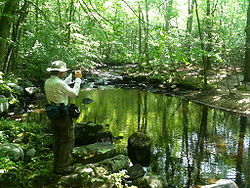
Vernal pond along the Menunkatuck Trail near the Iron Stream in the Timberlands town forest. Guilford, Connecticut. Length 11.0 miles (17.7 km) [1] Location Connecticut Designation CFPA Blue-Blazed Trail Use hiking, cross-country skiing, snowshoeing, fishing, mountain biking (parts of the trail), other Hazards hunters, deer ticks, poison ivy The Menunkatuck Trail is an 11.0-mile (17.7 km) Blue-Blazed hiking trail in Guilford, Connecticut and, currently, is almost entirely on protected land owned by the Town of Guilford, the Guilford Conservation Land Trust, the Regional Water Authority (RWA) and on Cockaponset State Forest land.
The mainline (official "Blue" "non-dot") trail is primarily a north / south linear trail with a northern trail head which terminates at the Mattabessett Trail near its southernmost point (approximately 1.3-mile (2.1 km) east of the Mattabessett Trail's intersection with (and "Bluff Head" parking lot on) Connecticut Route 77.
The current southern trail head terminates at a parking lot just outside the Town of Guilford's bulky waste site (and "Stump Dump" on Sullivan Drive just off Goose Lane (41°18′45″N 72°40′28″W / 41.3125°N 72.6745°W). Eventually the plan is for the Menunkatuck Trail to be extended to Long Island Sound (possibly via some road walks) but the trail currently is approximately 3.0-mile (4.8 km) directly due north of Guilford Harbor (and approximately 2.0-mile (3.2 km) due north of US I-95.)
Contents
Trail description
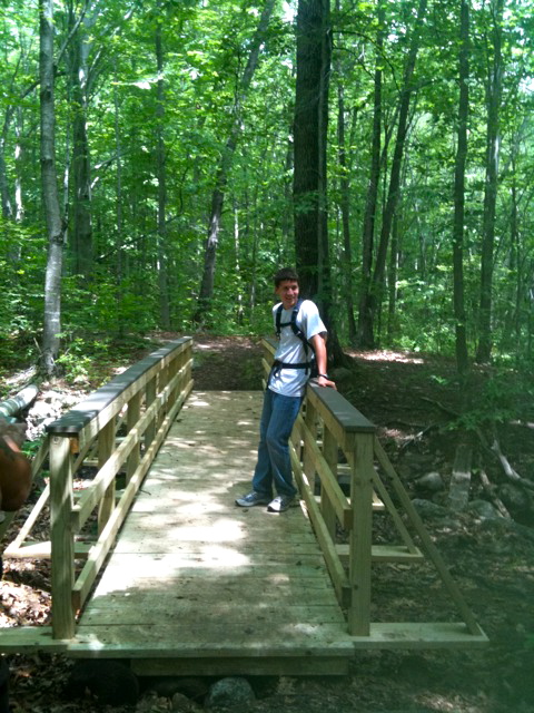
 This bridge over a stream in the Guilford section of the Cockaponset State Forest is this young man's Eagle Scout project.
The Menunkatuck Trail is primarily used for hiking, backpacking, picnicking, and in the winter, snowshoeing.Portions of the trail are suitable for, and are used for, cross-country skiing and geocaching. Site-specific activities enjoyed along the route include bird watching, hunting (very limited), fishing, horseback riding, bouldering and rock climbing (limited).
Trail communities
The official Blue-Blazed Menunkatuck Trail passes through land located within the following municipalities, from south to north:
History and folklore
The Blue-Blazed Menunkatuck Trail was created by the Connecticut Forest and Park Association.
Hiking the trail
The mainline trail is blazed with blue rectangles. Trail descriptions are available from a number of commercial and non-commercial sources, and a complete guidebook is published by the Connecticut Forest and Park Association
Weather along the route is typical of Connecticut. Conditions on exposed ridge tops and summits may be harsher during cold or stormy weather.[2] Lightning is a hazard on exposed summits and ledges during thunderstorms. Snow is common in the winter and may necessitate the use of snowshoes. Ice can form on exposed ledges and summits, making hiking dangerous without special equipment.
Biting insects can be bothersome during warm weather. Parasitic deer ticks (which are known to carry Lyme disease) are a potential hazard.Wearing bright orange clothing during the hunting season (Fall through December) is recommended.
Conservation and maintenance of the trail corridor
A large portion of the Menunkatuck Trail passes through or near protected wetlands: bogs, swamps, vernal ponds and marsh lands. Wooden walkways are planned to allow easy passage over some of these which flood or become muddy often.
There are sections of the trail which are narrow forested easements between streets of substantial houses. These protected green spaces are often 'set asides' created during residential housing development.
Much of the trail is protected, owned and managed by either the Town of Guilford (often by the Conservation Committee), the Guilford Conservation Land Trust or the state (as a part of the Cockaponset State Forest).
Land owned by the Regional Water Authority and private owners is not necessarily nor specifically protected but temporary easements have been negotiated to allow the trail to pass through these properties.
Recognition / Inspiration Programs
This trail system is a part of the 'Connecticut 400', one of the official Blue-Blazed (or similar) trails listed in the Connecticut Walk Book by the Connecticut Forest and Park Association (CFPA) and recognized, since 1976, with an award known as the Connecticut 400 Club by the Connecticut Chapter of the Appalachian Mountain Club (AMC). In 1976 there were only four hundred miles of Blue-Blazed trail but today (2010) the total length of the trails listed in the CFPA Connecticut Walk Books (East and West) exceeds 825 miles.[3][4][5]
The State of Connecticut Department of Environmental Protection (CT DEP) Forestry Division provides two awards for locating and visiting "letterboxes" (similar to geocaches) in Connecticut's State Forests. The commemorative 'State Forest Centennial Patch' is available to those who complete five sponsored "letterbox" hikes (in each separate state forest you must hike the described route, find the "letterbox/cache" and record your visit in the "letterbox" book). The State Forest Centennial campaign dates to 2003 (the centennial of the first official state forest in Connecticut). A walking stick is available for those who complete the letterbox hike of all thirty-two (32) of the state forests. Many of the "Blue-Blazed" hiking trails in Connecticut travel through or near one or more of the State Forests, often very close to the sponsored (DEP) letterbox.[6]
See also
- Blue-Blazed Trails
References
- ^ Colson, Ann T. (2006). Connecticut Walk Book West (19th edition). Connecticut Forest and Park Association. ISBN 0961905263.
- ^ NOAA
- ^ "The Connecticut 400". Rocks on Top. http://www.rocksontop.com/rocks/viewtopic.php?f=22&t=3408. Retrieved 2010-05-29.
- ^ Robinson, Ruth (1993-06-06). "Hikers Seek New Trails to Conquer". The New York Times. http://www.nytimes.com/1993/06/06/nyregion/hikers-seek-new-trails-to-conquer.html?sec=&spon=&pagewanted=all. Retrieved 2010-05-29.
- ^ "Hikes". Connecticut Museum Quest. http://www.ctmuseumquest.com/?page_id=23. Retrieved 2010-05-29.
- ^ "Forestry – Looking Beyond the Trees : Letterboxing in Connecticut's State Forests". Department of Environmental Protection, State of Connecticut. http://www.ct.gov/dep/cwp/view.asp?a=2697&q=322826&depNav_GID=1631. Retrieved 2010-05-29.
External links
Specific to this trail:
Further reading
- Books – Connecticut Hiking
- Colson, Ann (2005). Connecticut Walk Book East (19 ed.). Rockfall, Connecticut: Connecticut Forest and Park Association. pp. 1–261. ISBN 0961905255. http://books.google.com/books?id=x3vXPQAACAAJ.
- Colson, Ann (2006). Connecticut Walk Book West (19 ed.). Rockfall, Connecticut: Connecticut Forest and Park Association. pp. 1–353. ISBN 0961905263. http://books.google.com/books?id=5hZSAAAACAAJ.
- Emblidge, David (1998). Hikes in southern New England: Connecticut, Massachusetts, Vermont (1 ed.). Mechanicsburg, Pennsylvania: Stackpole Books. pp. 1–304. ISBN 0-8117-2669-X. http://books.google.com/books?id=H_4A-XrPYggC&lpg=PP1&pg=PP1#v=onepage&q&f=false.
- Keyarts, Eugene (2002). Pietrzyk, Cindi Dale. ed. Short Nature Walks: Connecticut Guide Book (7 ed.). Guilford, Connecticut: Falcon Publishing. pp. 1–192. ISBN 0-7627-2310-6. http://www.globepequot.com/isbn/0-7627-2310-6.
- Laubach, Rene; Smith, Charles W. G. (2007). AMC's Best Day Hikes in Connecticut (1 ed.). Guilford, Connecticut: Appalachian Mountain Club Books. pp. 1–320. ISBN 1-934028-10-X. http://www.globepequot.com/isbn/1-934028-10-X.
- Ostertag, Rhonda; Ostertag, George (2002). Hiking Southern New England (2 ed.). Guilford, Connecticut: Falcon Publishing. pp. 1–336. ISBN 0-7627-2246-0. http://www.globepequot.com/isbn/0-7627-2246-0.
- Books – Connecticut History and Geography
- De Forest, John (1853). History of the Indians of Connecticut from the earliest known period to 1850. Hartford, Connecticut: Wm. Jas. Hamersley. pp. 1–509. http://books.google.com/books?id=QysTAAAAYAAJ&dq=editions%3AHARVARD32044014634349&pg=PP1#v=onepage&q&f=false.
- Hayward, John (1857). New England Gazetteer: Containing Descriptions of the States, Counties, Cities and Towns of New England (2 ed.). Boston, Massachusetts: Otis Clapp. pp. 1–704. http://books.google.com/books?id=vMcMAAAAYAAJ&ots=qbWGmJHe8A&dq=New%20England%20Gazetteer%20states%20counties%20towns&pg=PR1#v=onepage&q=&f=false.
- Trumbull, Benjamin (1797). Volume One A Complete History of Connecticut - Civil and Ecclesiastical. Volume I (1818 printing ed.). New Haven, Connecticut: Maltby, Goldsmith & Co. and Samuel Wadsworth. pp. 1-1166. http://books.google.com/books?id=I2Z4ACHdrIoC Volume One.
- Trumbull, Benjamin (1797). Volume Two A Complete History of Connecticut - Civil and Ecclesiastical. Volume II (1818 printing ed.). New Haven, Connecticut: Maltby, Goldsmith & Co. and Samuel Wadsworth. pp. 1-1166. http://books.google.com/books?id=qwgWAAAAYAAJ&ots=N7363Fc8D4&dq=A%20Complete%20History%20of%20Connecticut%20-%20Civil%20and%20Ecclesiastical&pg=PR3#v=onepage&q&f=false Volume Two.
Hiking Trails in Connecticut Airline State Park Trail • Alain and May White Trails • American Legion • Appalachian Trail • Aspetuck Valley • Bigelow Hollow • Case Mountain • Charter Oak Greenway • Chatfield • Cockaponset • East Coast Greenway • Falls Brook • Farmington Canal Heritage Trail • Gay City • Hancock Brook • Hop River State Park Trail • Housatonic Range • Jericho • Kettletown • Lillinonah • Lone Pine • Macedonia Brook • Mattabesett • Mattatuck • McLean Game Refuge • Menunkatuck • Metacomet • Mohawk • Moosup Valley State Park Trail • Muir • Narragansett • Natchaug • Naugatuck • Nayantaquit • Nehantic • New England National Scenic Trail • Nipmuck • Old Furnace • Patchaug • Paugussett • Peoples • Pequot • Pine Knob • Pomperaug • Quinebaug • Quinnipiac • Ragged Mountain • Regicides • Salmon River • Saugatuck • Shenipsit • Sleeping Giant • Sleeping Giant State Park • Stony Creek Quarry • Sunny Valley Preserve • Tunxis • Washington–Rochambeau Revolutionary Route • Westwoods • Whitestone Cliffs • Wolcott Trail • Zoar

Protected areas of Connecticut National Park Service National Wildlife Refuges Silvio O. Conte • Stewart B. McKinney National Wildlife Refuge
National Trails State Parks Airline • Beckley Iron Furnace Industrial Monument • Bigelow Hollow • Black Rock • Bluff Point • Burr Pond • Camp Columbia • Campbell Falls • Chatfield Hollow • Collis P. Huntington • Connecticut Valley Railroad • Day Pond • Dennis Hill • Devil's Hopyard • Dinosaur • Fort Griswold Battlefield • Fort Trumbull • Gardner Lake • Gay City • George W. Seymour • Gillette Castle • Haddam Meadows • Haley Farm • Hammonasset Beach • Hampton Beach • Harkness Memorial • Haystack Mountain • Hop River State Park Trail • Hopeville Pond • Housatonic Meadows • Hurd • Indian Well • John A. Minetto • Kent Falls • Kettletown • Lake Waramaug • Larkin State Park Trail • Levy • Lovers Leap • Macedonia Brook • Mansfield Hollow • Mashamoquet Brook • Millers Pond • Mohawk Mountain • Moosup Valley State Park Trail • Mount Tom • Old Furnace • Osbornedale • Penwood • Putnam Memorial • Quaddick • Quinnipiac River • River Highlands • Rocky Neck • Selden Neck • Seth Low Pierrepont • Sherwood Island • Silver Sands • Sleeping Giant • Southford Falls • Squantz Pond • Stratton Brook • Talcott Mountain • Wadsworth Falls • West Rock Ridge • Wharton Brook • Windsor Locks Canal State Park Trail
State Forests Algonquin • American Legion • Centennial Watershed • Cockaponset • Enders • James L. Goodwin • Housatonic • Massacoe • Mattatuck • Meshomasic • Mohawk • Mohegan • Nassahegon • Natchaug • Nathan Hale • Nehantic • Nepaug • Nipmuck • Nye-Holman • Pachaug • Paugnut • People's • Pootatuck • Quaddick • Salmon River • Shenipsit • Topsmead • Tunxis • Wyantenock
Categories:- Hiking trails


Wikimedia Foundation. 2010.