- Milner Dam
-
Milner Dam 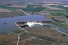
Location Jerome / Twin Falls counties, Idaho, USA Coordinates 42°31′28″N 114°0′35″W / 42.52444°N 114.00972°W [1] Opening date 1905[2] Dam and spillways Height 73 feet (22 m)[2] Length 2,160 feet (658 m)[2] Impounds Snake River Spillway capacity 116,750 cu ft/s (3,306 m3/s) Reservoir Creates Milner Lake Capacity 36,300 acre feet (44,800,000 m3)[2] Catchment area 17,180 sq mi (44,496 km²)[2] Surface area 4,000 acres (16 km²)[2] Milner Dam and the Twin Falls Main CanalArea: 340 acres (140 ha) Built: 1902 Architect: Wiley, A.J. Architectural style: Rock and earth fill dam Governing body: Private NRHP Reference#: 86001720
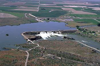
[3]Added to NRHP: July 10, 1986 Milner Dam is a rockfill dam near Burley in south central Idaho. It impounds the Snake River in a reservoir named Milner Lake. The dam spans the river across two islands, with three embankments.
Milner Dam was authorized for construction as a privately-capitalized venture under the 1894 Carey Act, a precursor to the 1902 Reclamation Act.[4] Ira Burton Perrine, a local rancher, chose the site and recruited financial backers, including Salt Lake City banker Stanley B. Milner and eastern investors Frank H. Buhl and Peter L. Kimberly. The Buhl-Kimberly Corporation built the dam and the Twin Falls Canal in 1903-1905.[5] Milner Dam's primary purpose is irrigation but it also produces hydroelectricity. It is currently owned and operated by Milner Dam, Inc.
The dam is 73 feet (22 m) high and 2,160 feet (660 m) long. The storage capacity of its reservoir, Milner Lake, is 36,300 acre feet (44,800,000 m3). The lake covers 4,000 acres (16 km²).
Inspections in 1988 indicated a high risk of dam failure in an earthquake. In order to pay for the $11 million cost of rebuilding the dam, the operating companies contracted with Idaho Power to build a 57.5 megawatt hydroelectric powerplant 1.5 miles (2.4 km) downstream from the dam, with Idaho Power in return loaning funds for the dam's reconstruction. The powerplant has 46 and 11.5 MW generators, with a small 800 KW generator for low-flow conditions. Water for the powerplant is drawn from the Twin Falls Canal during seasons when water is not needed for irrigation.[5]
Milner Dam was placed on the National Register of Historic Places on July 10, 1986.[3]
References
- ^ U.S. Geological Survey Geographic Names Information System: Milner Dam, USGS, GNIS
- ^ a b c d e f Milner Dam, NPDP Dam Directory
- ^ a b "National Register Information System". National Register of Historic Places. National Park Service. 2009-03-13. http://nrhp.focus.nps.gov/natreg/docs/All_Data.html.
- ^ Jackson, Donald C. (1988). Great American Bridges and Dams. The Preservation Press. pp. 290–291. ISBN 0-89133-129-8.
- ^ a b Yost, Joe. "Milner Dam". Twin Falls Canal Company. http://www.tfcanal.com/milner.htm. Retrieved 24 May 2011.
External links
- Milner Dam at the Twin Falls Canal Company
Snake River Dams Ice Harbor • Lower Monumental • Little Goose • Lower Granite • Hells Canyon • Oxbow • Brownlee • Swan Falls • C. J. Strike • Milner • Minidoka • Palisades • American Falls • Jackson LakeU.S. National Register of Historic Places Topics Lists by states Alabama • Alaska • Arizona • Arkansas • California • Colorado • Connecticut • Delaware • Florida • Georgia • Hawaii • Idaho • Illinois • Indiana • Iowa • Kansas • Kentucky • Louisiana • Maine • Maryland • Massachusetts • Michigan • Minnesota • Mississippi • Missouri • Montana • Nebraska • Nevada • New Hampshire • New Jersey • New Mexico • New York • North Carolina • North Dakota • Ohio • Oklahoma • Oregon • Pennsylvania • Rhode Island • South Carolina • South Dakota • Tennessee • Texas • Utah • Vermont • Virginia • Washington • West Virginia • Wisconsin • WyomingLists by territories Lists by associated states Other  Category:National Register of Historic Places •
  Portal:National Register of Historic PlacesCategories:
- Dams in Idaho
- Hydroelectric power plants in Idaho
- Buildings and structures in Jerome County, Idaho
- Snake River
- National Register of Historic Places in Idaho
- Dams on the National Register of Historic Places
- Buildings and structures in Twin Falls County, Idaho
- Idaho geography stubs
Wikimedia Foundation. 2010.