- Nattai National Park
-
Nattai National Park 
Nearest town/city Oakdale Coordinates 34°17′22″S 150°21′37″E / 34.28944°S 150.36028°E Area 489.44 km² Established December 13, 1991 Visitation 1000 (in 1997) Managing authorities New South Wales National Parks and Wildlife Service Official site Nattai National Park 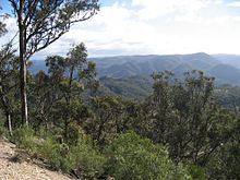 Nattai National Park, Wollondilly Lookout.
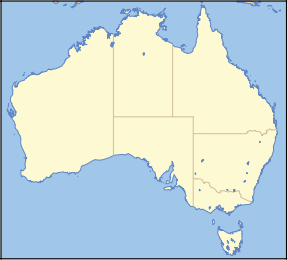
Nattai is a national park in New South Wales (Australia), 150 km southwest of Sydney. It is part of the Greater Blue Mountains World Heritage Area, and primarily encompasses the valley of the Nattai River, which is surrounded by spectacular sandstone cliffs. The park is covered in dry sclerophyll (hard leafed) forest - mostly eucalypt, and has fairly frequent forest fires. It is largely an untouched wilderness area.
The park adjoins the Kanangra-Boyd National Park (which is to the north). Lake Burragorang (water supply for Sydney) also borders the northern side of the park, and there is a 3 km exclusion zone surrounding into which entry is prohibited.
The Nattai receives very few visitors, as it has virtually no facilities and is fairly remote, despite its proximity to Sydney.
Contents
History
The area now known as Nattai National Park has limited impact from Europeans. Several early expeditions attempting to cross the Blue Mountains passed though the area at the end of the 18th century, and settlers settled in the lower Nattai and Burragorang Valleys in 1827.[1] Early conservationists Myles Dunphy and Herb Gallop went on bushwalks in the region from 1912 onwards. An area held in high regard was a forest of Sydney blue gum around Blue Gum Creek. Dunphy lobbied for the stand to be preserved upon becoming aware of plans to log the area, but was unsuccessful and the area was logged in the 1920s and 30s. Dunphy put forward a plan for a Greater Blue Mountains National Park, which incorporated what is now Nattai National Park in the southeast in 1932. The creation of Warragamba Dam in 1960 limited access for development of land upstream, but it was not until 1991 when plans for permanent protection and national park status looked to become realised.[2]
Entry points
- Wattle Ridge Fire Road
- Northeast of the small town of Hill Top. Unsealed road access to a small unsealed car park at the edge of the park - a four wheel drive vehicle is not required. There are no facilities, just an information board, and a log book. Make sure you sign in and out of the log book when entering the park.
- Wombeyan Caves Road
Hiking
Nattai National Park has several worthwhile hikes, however it is a remote area, and also very dry. Bush camping is allowed anywhere outside the Lake Burragorang exclusion zone, but destruction of plants is not allowed, so choose your campsite well, and use tents with smaller footprints. At the Mittagong visitors information center you would should try to get a copy of a yellow covered book that discusses in depth walks in the Nattai, it is invaluable. The book was published in 1998 but hopefully it is still available, it is a great reference for this little known and isolated area.
When to go
In summer it can be extremely hot walking along the fire roads, and at camp sites is far too hot to get inside a tent until quite late.
Dangers and annoyances
- Water is very scarce away from the Nattai River and its tributary creeks. Ensure everyone carries enough.
- The area is fairly remote, and few people hike here, so make sure your plans are left with a responsible person, and consider taking an EPIRB. Mobile phones may work on the highest parts of the plateau surrounding the valley, but won't work in the valley.
- Make sure your navigation skills are adequate to route find properly, as fires in the park often clear out undergrowth, which makes finding an indistinct trail nearly impossible (although it also means that walking is much easier).
- Beware of snakes, especially sunning themselves on fire roads or trails and near creeks - they won't always move away when you come near, so you may end up getting uncomfortably close to one. Red-bellied Black Snakes are the most common type seen. Make sure you carry snake bandage(s) and know how to use them.
- Treat all water taken from rivers/creeks - there are towns (e.g. Mittagong) upstream, so there is likely to be Giardia in the water.
- Be aware that when there has been recent and/or substantial rainfall there are lots of thorny vines, spiky plants and stinging nettles nearby the river. It is best to have attire that will protect your legs and hands under these circumstances.
- There are lots of wombat burrows and soil that has been disturbed by wombats.
Trails
- The Starlights Trail
- Nattai Road Park Entrance to Emmetts Flat (a good camp site on the river without facilities) on the Nattai River. 6.5 km one way with 550 m descent, approx. You begin at an elevation of roughly 640 m and descend to 93 m which is the altitude of the river. [These are aggregate measurements based on topographical maps and GPS]
- Russells Needle
- Extension of Starlights Trail from Emmetts Flat south along the Nattai River to a tall rock spire
- Katoomba to Mittagong
- A well known long distance trail, through the heart of the Greater Blue Mountains World Heritage Area - 132 km
Climbing
References
Cited text
- Wright, Peter (1996). National Parks of Southern NSW. Rosebery, NSW: Bridge Printery. ISBN 0-958759-01-4.
See also
- Protected areas of New South Wales (Australia)
- Free online topographic maps of Nattai - NSW Dept of Lands Spatial Portal
Blue Mountains topics Towns, suburbs
& localitiesBell • Berambing • Bilpin • Blaxland • Blackheath • Bullaburra • Faulconbridge • Glenbrook • Hartley Vale • Hazelbrook • Katoomba • Kings Tableland • Lapstone • Lawson • Leura • Linden • Little Hartley • Medlow Bath • Megalong • Mount Irvine • Mount Riverview • Mount Tomah • Mount Victoria • Mount Wilson • North Katoomba • Shipley • Springwood • Sun Valley • Valley Heights • Warrimoo • Wentworth Falls • Winmalee • Woodford • Yellow Rock • Yosemite
Mountain peaks Mount Banks · Mount Bindo · Mount Boyce · Mount Hay · Mount Irvine · Mount Piddington · Mount Solitary · Mount Trickett · Mount Wilson · Mount York · Narrow Neck PlateauTourist attractions Valleys Waterfalls Wentworth FallsHistory National Parks Miscellaneous Categories:- IUCN Category II
- National parks of New South Wales
- Protected areas established in 1991
- 1991 establishments in Australia


Wikimedia Foundation. 2010.