Middle Brother National Park
- Middle Brother National Park
-
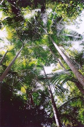
Middle Brother National Park is a protected area of 1830 hectares, situated in the Mid North Coast region of New South Wales. The nearest large town is Laurieton. The high rainfall and volcanic soils produce outstanding eucalyptus forest and rainforest. Large Flooded Gum and Blackbutt grow in sheltered areas.
See also
References
| v · d · eNational Parks of New South Wales |
|
| Central NSW |
|
|
| Hunter and Mid North Coast |
|
|
| New England Tablelands |
|
|
| Northern Rivers |
|
|
| Outback NSW |
|
|
| South Coast and Highlands |
|
|
| Sydney and Surrounds |
|
|
Categories:
- IUCN Category II
- National parks of New South Wales
- Forests of New South Wales
- 1999 establishments in Australia
- New South Wales protected area stubs
Wikimedia Foundation.
2010.
Look at other dictionaries:
Middle-Brother-Nationalpark — Bangalow Palm (Archontophoenix cunninghamiana) im Middle Brother Nationalpark … Deutsch Wikipedia
Middle Brother — For the mountain in Australia, see Three Brothers, New South Wales. For the island, see Middle Brother Islet, Queensland. For the national park, see Middle Brother National Park. Middle Brother Genres Indie folk, Folk rock, Alternative country… … Wikipedia
Mammoth Cave National Park — Mammoth Cave redirects here. For other uses, see Mammoth Cave (disambiguation). Mammoth Cave National Park IUCN Category II (National Park) The Rotund … Wikipedia
Cuyahoga Valley National Park — IUCN Category II (National Park) Bedrock outcrops, such as this one, can be found throughout the park … Wikipedia
Capitol Reef National Park — Infobox protected area | name = Capitol Reef National Park iucn category = II caption = locator x = 64 locator y = 84 location = Wayne, Garfield, Sevier, and Emery counties, Utah, USA nearest city = Torrey lat degrees = 38 lat minutes = 12 lat… … Wikipedia
Myall Lakes National Park — IUCN Category II (National Park) Coordinates 32°29′41″S 152°20′11″E … Wikipedia
New England National Park — IUCN Category Ib (Wilderness Area) … Wikipedia
Mallee Cliffs National Park — IUCN Category Ia (Strict Nature Reserve) … Wikipedia
Mount Kaputar National Park — Coordinates: 30°17′26″S 150°08′34″E / 30.29056°S 150.14278°E / 30.29056; 150.14278 … Wikipedia
Mount Royal National Park — IUCN Category II (National Park) eucalyptus on a steep ridge near Mount Royal Coordinates … Wikipedia

