- Coolah Tops National Park
-
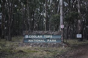
Coolah Tops National Park Coolah Tops National Park entrance Nearest town/city Coolah Coordinates 31°45′03″S 150°04′17″E / 31.75083°S 150.07139°ECoordinates: 31°45′03″S 150°04′17″E / 31.75083°S 150.07139°E Established 5 July 1996 Managing authorities NSW National Parks and Wildlife Service Coolah Tops is a national park in New South Wales, Australia, 258 km northwest of Sydney, established on 5 July 1996. It is managed by the New South Wales National Parks and Wildlife Service. Its World Conservation Union category is II. It is situated 30 kilometres east of Coolah in the Liverpool Range, on the Coolah Creek Road.
The park features waterfalls that plunge from the plateau. Giant grass trees and open forest with stands of snow gums shelter gliders, wallabies, eagles and owls.
Camping and walking are the main recreational activities performed here. Views from the tops are possible over the Liverpool Plains.
The sources of the Talbragar River and the Coolaburragundy River lie in the park.
See also
Categories:- IUCN Category II
- National parks of New South Wales
- Protected areas established in 1996
- 1996 establishments in Australia
- New South Wales protected area stubs
Wikimedia Foundation. 2010.


