- Hartley, New South Wales
Infobox Australian Place | type = town
name = Hartley
state = nsw

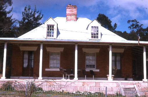
caption = Building in Hartley
lga =City of Lithgow
postcode =
est =
pop =
elevation=
maxtemp =
mintemp =
rainfall =
stategov = Bathurst
fedgov = Calare
dist1 =
location1=Hartley is a town in
New South Wales ,Australia , in theCity of Lithgow , located approximately 150 kilometres west of Sydney. [Gregory's New South Wales State Road Map, Map 220, 11th Edition, published by Gregory's Publishing Company] It is below the western escarpment of the Blue Mountains. It was once a major administrative center on theGreat Western Highway . It has since fallen into decline, replaced by other towns that are on the railway line.History
Hartley was formerly a gold rush town and had a busy courthouse that was built in the 1830s. The courthouse, which operated for over fifty years, dealt with a constant stream of robbers, thieves and convicts. Although Hartley fell into disuse, it survived as a perfectly preserved village that was a superb example of 19th century architecture. Because of its heritage value, it is now preserved as a historic site, administered by the National Parks and Wildlife Service of New South Wales. [Guide to New South Wales National Parks, NPWS, 2001] Situated 120 kilometres west of Sydney and 12 kilometres south of Lithgow, it is open to the public every day. The Hartley Historic Site, an area of 7.7 hectares, is listed on the Register of the National Estate. [The Heritage of Australia, Macmillan Company, 1981, p.2/273]
Hartley's sister villages,
Little Hartley andHartley Vale , still survive as residential villages with a heritage of their own. Little Hartley, situated 4 kilometres south-east of Hartley, is the site of the historic homeRosedale . Hartley Vale, situated 6 kilometres east of Hartley, is the site of theComet Inn ,Collits Inn andHartley Vale cemetery . [Hartley Topographic Map 8930-4N Department of Lands, New South Wales] [Blue Mountains Tourist Map, Department of Lands, New South Wales] There is also a network of historic walking tracks between Hartley Vale andMount York , administered by the Lands Department of New South Wales. [Sydney and Blue Mountains Bushwalks, Neil Paton (Kangaroo Press) 2004, pp.236-238]Gallery
ee also
* Blue Mountains
*Lithgow, New South Wales
*Jenolan Caves References
External links
* [http://www.nationalparks.nsw.gov.au National Parks and Wildlife Service of New South Wales]
Wikimedia Foundation. 2010.
