- Narrow Neck Plateau
-
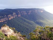
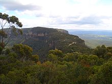
The Narrow Neck Plateau is the eroded remnant of a sandstone layer 1000m above sea level situated immediately south-west of Katoomba, New South Wales, Australia in the Blue Mountains. The neck separates the Jamison Valley (to the east) from the Megalong Valley (to the west).
Contents
Description
Accessible to a locked gate by car over a short dirt road (Glenraphael Drive) from Katoomba, the Narrow Neck is a popular walking, bike riding and climbing location and offers several walking descent routes to the adjacent valleys. Beyond the gate is walking access only for the general public. One of the most popular walks is the Golden Stairs, a rough descent of approximately 200m to join the Federal Pass. This opens up the Jamison Valley for popular day walks to sites such as Mount Solitary and the Ruined Castle. The neck juts southwards from Katoomba for a distance of some ten kilometres and ends at Clear Hill, overlooking the Wild Dog Mountains. Castle Head promontory points towards the Ruined Castle, a small rock formation between Castle Head and Mount Solitary.[1]Arguably one of the best views on the eastern seaboard of NSW is from Narrow Neck Fire Tower. On a day of high visibility it is possible to see from Mittagong in the south to Toronto in the north and everything in between. It also has excellent views back towards the escarpment at Katoomba.
Missing Persons
Nineteen year-old British Backpacker Jamie Neale was found after 12 days lost in the Blue Mountains at medlow gap, they proceeded leave via the Narrow Neck fire trail, around 15km from Katoomba. Two bushwalkers alerted emergency services who were conducting an extensive search using the Police Rescue Squad, police dogs, State Emergency Service and Rural Fire Service.[2] Mr Neale was found at around 11.30am on Wednesday, 15 July 2009, reportedly well.
References
- ^ Sydney and Blue Mountains Bushwalks, Neil Paton (Kangaroo Press) 2004, pp.222-228
- ^ Backpacker Jamie Neale found after 11 days
External links
- Blue Mountains, NSW, Australia Aerial video footage of Narrow neck and the area around Katoomba.
- "Blue Mountains Wilderness", by Harry Loots. From the April 1997 issue of the newsletter of the Harbourside Group of SGAP.
- Narrow Neck Plateau is at coordinates 33°45′37″S 150°15′55″E / 33.76035833°S 150.2652667°ECoordinates: 33°45′37″S 150°15′55″E / 33.76035833°S 150.2652667°E
Blue Mountains topics Towns, suburbs
& localitiesBell • Berambing • Bilpin • Blaxland • Blackheath • Bullaburra • Faulconbridge • Glenbrook • Hartley Vale • Hazelbrook • Katoomba • Kings Tableland • Lapstone • Lawson • Leura • Linden • Little Hartley • Medlow Bath • Megalong • Mount Irvine • Mount Riverview • Mount Tomah • Mount Victoria • Mount Wilson • North Katoomba • Shipley • Springwood • Sun Valley • Valley Heights • Warrimoo • Wentworth Falls • Winmalee • Woodford • Yellow Rock • Yosemite
Mountain peaks Mount Banks · Mount Bindo · Mount Boyce · Mount Hay · Mount Irvine · Mount Piddington · Mount Solitary · Mount Trickett · Mount Wilson · Mount York · Narrow Neck PlateauTourist attractions Valleys Waterfalls Wentworth FallsHistory National Parks Miscellaneous Categories:- New South Wales geography stubs
- Blue Mountains, New South Wales
- Geography of New South Wales
- Plateaus of Australia
Wikimedia Foundation. 2010.


