- Knucklas
-
Coordinates: 52°19′25″N 3°01′43″W / 52.3236°N 3.0285°W
Knucklas & Heyop(e) Welsh: Cnwclas 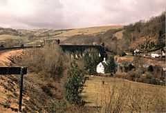
Knucklas Viaduct, on the Central Wales Line, and the village of Heyope beneath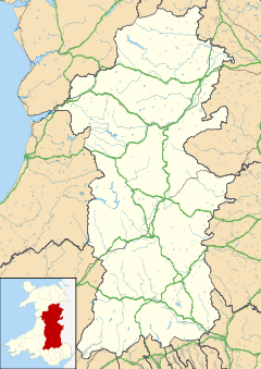
 Knucklas & Heyop(e)
Knucklas & Heyop(e) shown within PowysPopulation 220 [1] OS grid reference SO300700 Principal area Powys Ceremonial county Powys Country Wales Sovereign state United Kingdom Post town Knighton Postcode district LD7 Dialling code 01547 Police Dyfed-Powys Fire Mid and West Wales Ambulance Welsh EU Parliament Wales UK Parliament Brecon & Radnorshire List of places: UK • Wales • Powys Knucklas (Welsh: Cnwclas, "Green Hill") and Heyop (or Heyope) are two small but inseparable villages in Powys, Wales. They lie off the B4355 road and are served by Knucklas railway station on the Heart of Wales Line. Both are approximately 2 miles (3.2 km) from Knighton and lie in the upper valley of the River Teme and also a stone throw away from the English border and nearby county of Shropshire.
Contents
Historic Knucklas
Knucklas has two notable historical survivals:
- The Castle Mound is a protected ancient monument in the care of Cadw[1]. It dates from 1240[citation needed] but was possibly built on earlier foundations. It consisted of a keep - a square stone fortification with four round towers on top of a steep hill. There is some evidence that there may have been further outer walls. It was captured by a Welsh army in 1262 which destroyed the defences[2][3].Below the castle lies the battlefield of the Battle of Beguildy[citation needed] fought between the Welsh and the Mortimer family of Norman Marcher Lords in 1146. The castle was attacked and destroyed by the forces of Owain Glyndŵr in 1402 during his rebellion. Whilst there is a romantic story associating the castle location with the marriage of Guinevere and King Arthur[3]. this probably developed from an earlier story which suggested that a marriage took place between Gwenhwyfar, the daughter of Ogrfan Gawr (also called 'Gogrfan Gawr "the Giant" of Castell y Cnwclas' (Knucklas Castle)) and Arthur the warrior - there being no reference to Arthur as a king in the early Welsh texts.
- The Viaduct. A spectacular 13-arch span completed in 1865 and recorded in an engraving from the Illustrated London News[4].
Historic Heyope
Three *Bronze Age torcs were found here and declared treasure in 1991[citation needed]. They are now housed in the National Museum, Cardiff. Further reading : Noble, F, 1955, 'The Bronze Age gold torcs from Heyope', Transactions of the Radnorshire Society 25, 34-8.
References
- ^ Cadw website
- ^ "eCastles Website". http://www.ecastles.co.uk/knucklas.html. Retrieved 03 Dec 2007.
- ^ a b "Castle Wales Website". http://www.castlewales.com/knucklas.html. Retrieved 03 Dec 2007.
- ^ "Gathering the Jewels". http://www.gtj.org.uk/en/item1/19757. Retrieved 03 Dec 2007.
External links
- Aerial photograph of Knucklas
- Anglo-Norman Castles
- Useful Archaeological Records
- Photos of Knucklas and surrounding area on geograph.org.uk
- Photo of Arriva Trains Wales Class 153 Passing over Knucklas Viaduct
Categories:- Villages in Powys
- Powys geography stubs


Wikimedia Foundation. 2010.