- Newbridge-on-Wye
-
Coordinates: 52°12′49″N 3°26′29″W / 52.2137°N 3.4415°W
Newbridge-on-Wye Welsh: Pontnewydd ar Wy
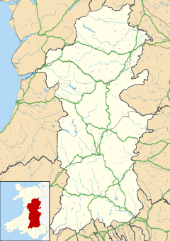
 Newbridge-on-Wye shown within Powys
Principal area Powys Ceremonial county Powys Country Wales Sovereign state United Kingdom Post town LLANDRINDOD WELLS Postcode district LD1 Dialling code 01597 Police Dyfed-Powys Fire Mid and West Wales Ambulance Welsh EU Parliament Wales UK Parliament Brecon & Radnorshire List of places: UK • Wales • Powys Newbridge-on-Wye (Welsh: Pontnewydd ar Wy) is a small village in Powys, Wales. It lies, as its name suggests, on the River Wye, just downstream from the market town of Rhayader.
Contents
Location
Newbridge-on-Wye is located roughly in the middle of Wales, and lies 7.1 miles south of Rhayader.[1] The main road running through the village is the A470, running from Rhayader to the north and Builth Wells to the south. The B4358 also passes through the village; it runs from Beulah in the west through to Llandrindod Wells in the east. This road system is useful for commuters traveling from west and north-west Wales to areas in the south.
History
Newbridge-on-Wye was historically a stop off point for drovers, who moved livestock from place to place. Newbridge-on-Wye proved to be an ideal location for drovers to stop and rest because it afforded a safe crossing-point on the river Wye. This led to a settlement forming, including a large number of pubs. This fact is celebrated by the statue of a drover on the village green. Newbridge-on-Wye also sited a railway station on the Mid Wales Railway, until its closure on December 31, 1962. The site of the station is now occupied by a housing estate, although the old railway bridge still remains.[2]
Newbridge-on-Wye Football Club
Main article: Newbridge F.C.Newbridge-on-Wye Football Club is one of the most successful village teams in Wales. The team currently plays in the Spar Mid Wales League. The team's greatest success was during the 2004/2005 season where they won the Mid Wales South League.[3] The football club applied for promotion and this was granted in the next season following extensive work to their Penybont ground in order to meet the standards set by the FAW. During the 2005/2006 season, their first in the Spar Mid Wales League, they placed 12th. However during the 2007/2008 they set up a strong challenge for the title, only to see a good start to the season diminished through poor results in the latter part of the season. They ended up coming 7th, although this was behind a number of Welsh Premier reserve teams from much larger areas than Newbridge-on-Wye.[4]
Newbridge-on-Wye Church In Wales Primary School
There has been a primary school present in Newbridge-on-Wye since 1868. The original school was subsequently replaced by a larger school in 1962.[5] The second school was larger than the previous one, although it still remained relatively small, educating around 80 children in four main classrooms. It is situated just off the main road (A470) and has a large grass playing area at the back of the school. In March 2008 Powys County Council announced that the second school was to be demolished, and a £2.5-million replacement to be built at the same site. Although the initial plan was to renovate the old school the council concluded that it would be more cost effective to build an entirely new one, that will accommodate around 118 pupils and will acquire a lower environmental impact (purportedly a 40% reduced energy consumption).[6] Demolition of the old building started in the summer of 2008, with a view to finish construction of the new building in September 2009. During this time students at the school were educated in portable classrooms located on the school field.[6]
Across the road is the All Saints Church, which the school is linked with. The school holds festivals and services in the church throughout the year. During the 2005 ESTYN inspection, the school rated very highly, with special praise given to the school's ability to create an "environment where the children can flourish".[5]
References
Coordinates: 52°12′49″N 3°26′29″W / 52.2137°N 3.4415°W
Categories:- Villages in Powys
Wikimedia Foundation. 2010.


