- Llanfyllin
-
Coordinates: 52°45′59″N 3°16′21″W / 52.766371°N 3.272638°W
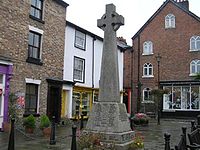 Llanfyllin Town Square
Llanfyllin (
 Welsh pronunciation (help·info)) is a small town in Powys, Mid Wales, United Kingdom.
Location, history and amenities
Llanfyllin's population at the date of the 2001 Census was 1,407.[1] The town lies on the River Cain by the Berwyn Mountains in Montgomeryshire. It is known for its holy well, dedicated to Saint Myllin. The A490 road terminates just after passing through the town. Granted its charter in the medieval era, Llanfyllin became a market town.
The town has a number of small specialist shops, a primary school and a high school. Over half the population has knowledge of the Welsh language.[citation needed]
Llanfyllin High School, with approximately 1000 pupils,[2] is a bilingual secondary school based in the town. It consistently performs well at GCSE level (5 GCSEs, grades A-C).[citation needed] In 2000, it had a pass rate of 74%[citation needed] and was the 12th best secondary school in Wales[citation needed] based on these results. In 2010, 93.4% of GCSE students achieved 5 A* to C and at A-level 77% of passes were A*-C.[3] According to the latest inspection report from Estyn the school's pass rate is now 71%[citation needed] which puts it in 15th place or well in the top 10%[citation needed] of secondary schools in Wales.
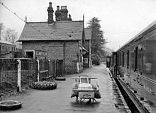 Until 1960 Llanfyllin had a railway station on the line to Oswestry
Llanfyllin is also increasingly well known for the old Union Workhouse, known as Y Dolydd locally. Built in 1838 this old Victorian building had stood empty since the mid-1980s until a local voluntary group, the Llanfyllin Workhouse project, got involved and are slowly renovating it to a make local centre for Arts, Creativity and Environment. It is also home to the renowned Llanfyllin Workhouse Festival.
The Church in Wales parish church of St. Myllin was founded in the seventh century by the Irish Bishop Molling (Mylling). The present building dates back to 1706.
External links
- www.geograph.co.uk : photos of Llanfyllin and surrounding area
- Llanfyllin community council website, history and info
- BBC Wales feature on the town
- Llanfyllin Town F.C. website
- Llanfyllin High School website
- Llanfyllin Workhouse - arts, education and community website
- Llanfyllin Workhouse Festival website
References
- ^ http://neighbourhood.statistics.gov.uk/dissemination/LeadTableView.do?a=7&b=6099436&c=llanfyllin&d=14&e=13&g=415445&i=1001x1003x1004&m=0&r=1&s=1245360255125&enc=1&dsFamilyId=75
- ^ http://www.llanfyllin-hs.powys.sch.uk/index.php?option=com_docman&task=doc_details&gid=131&Itemid=129&lang=en
- ^ http://www.llanfyllin-hs.powys.sch.uk/index.php?option=com_docman&task=doc_details&gid=131&Itemid=129&lang=en
Categories:- Towns in Powys
- Powys geography stubs


Wikimedia Foundation. 2010.