- Erwood
-
Coordinates: 52°04′42″N 3°19′10″W / 52.0784°N 3.3195°W
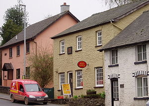
Erwood (Welsh: Erwyd) is a village lying along the A470 road, roughly 6.5 miles (10.5 km) south of Builth Wells, Powys, Wales. It is in the former county of Breconshire and the older cantref of Cantref Selyf. The Clettwr brook runs through Erwood to join the River Wye and separates the village between the parishes of Gwenddwr to the north and Crickadarn to the south. The Church of St Dubricius, Gwenddwr was extensively rebuilt in the Victorian period after a fire.[1]
Erwood is overlooked from across the Wye by Twyn y Garth, which is 325m high.[2] On the summit of Twyn y Garth is a German field howitzer, a trophy from World War I, which is pointed at Erwood by the neighbouring county of Radnorshire as part of a running joke.
At the southern end of the community, on the Scithwen Brook, is Trericket Mill where Roderick Murchison recorded that he had identified "the first true Silurian".[3]
Village name
The name Erwood is unmistakably a corruption of the Welsh term Y Rhyd, meaning The Ford.[citation needed] This is supported by the fact that drovers used to ford the Wye at Erwood to continue driving their livestock towards the Midlands and eventually London, where they would sell their livestock.
Village life
The Erwood Community consists of the village, the two ancient parishes of Gwenddwr and Crickadarn, and the former Forestry Commission hamlet of Llaneglwys. The village is the centre of a flourishing branch of the Young Farmers' Club. The village shop and post office no longer exists, and of the two pubs one, The Erwood Inn, has recently changed to a private house offering bed and breakfast accomodation.[4]
Up to 1962 Erwood railway station, about 1 kilometre (0.6 miles) away, served the village.
References
- ^ [1]
- ^ Ordance Survey of the United Kingdom
- ^ Duncan Hawley, Proceedings of the Geologists' Association
- ^ Erwood Inn as guest house
Categories:- Villages in Powys
Wikimedia Foundation. 2010.


