- New Siberian Islands
-
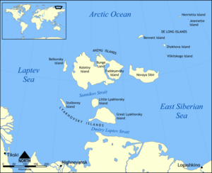 The New Siberian Islands.
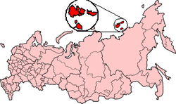 Location of the New Siberian Islands.
Contents
The New Siberian Islands (Russian: Новосиби́рские острова, Novosibirskiye Ostrova) are an archipelago, located to the North of the East Siberian coast between the Laptev Sea and the East Siberian Sea north of the Sakha (Yakutia) Republic.
The New Siberian Islands proper, or Anzhu Islands, covering a land area of about 29,000 km², consist of
- Kotelny Island (о. Коте́льный) 11,700 km² and
- Faddeyevsky Island (о. Фадде́евский) 5,300 km²
- Both linked by Bunge Land (земля́ Бу́нге) 6,200 km² (occasionally submerged by sea). Very close to Bunge Land's northwestern coast there are two islands: Zheleznyakov Island (Ostrov Zheleznyakova), right off the NW cape and, east of it, Matar Island (Ostrov Matar). Both islands are about 5 km in length.
- Nanosnyy Island 76°16′59″N 140°24′58″E / 76.283°N 140.416°E is a small island located due north off the northern bay formed by Kotelny and Bunge. It is C-shaped and only 4 km in length, but its importance lies in the fact that it is the northernmost island of the New Siberian group.
- Novaya Sibir (о. Но́вая Сиби́рь) 6,200 km²
- Belkovsky Island (о. Бельковский) 500 km²
To the south and nearer to the Siberian mainland lie the Lyakhovskiye Islands (6,095 km²):
- Great Lyakhovsky Island (о. Большо́й Ля́ховский) 4,600 km²
- Little Lyakhovsky Island (о. Ма́лый Ля́ховский) 1,325 km²
- Stolbovoy Island (о. Столбово́й) 170 km²
- Semyonovsky Island (о. Семёновский) 0 km² (now submerged)
The small De Long Islands (228 km²) lie to the north-east of Novaya Sibir. These islands are usually not considered as part of the New Siberian group:
- Jeannette Island (о. Жанне́тты)
- Henrietta Island (о. Генрие́тты)
- Bennett Island (о. Бе́ннетта)
- Vilkitsky Island (о. Вильки́цкого)
- Zhokhov Island (о. Жо́хова)
The new Siberian Islands are low-lying. Their highest point is Mt. Malakatyn-Tas on Kotelny island with an elevation of 374 m.
The New Siberian Islands were once major hills within the Great Arctic Plain that once formed northern part of Late Pleistocene “Beringia” between Siberia and Alaska during the Last Glacial Maximum (Late Weichselian Epoch). These islands are what remains of about 1.6 million square kilometers of the formerly subaerial Great Arctic Plain that now lies submerged below parts of the Arctic Ocean, East Siberian Sea, and Laptev Sea. At this plain's greatest extent, sea level was 100–120 m below modern sea level and the coastline was located 700-1000 kilometers north of its current position. This plain was neither extensively glaciated during the Late Pleistocene nor the Last Glacial Maximum because it lay in the rain shadow of the Northern European ice sheet. During the frigid polar climate of the Last Glacial Maximum, 17,000 to 24,000 BP, small passive ice caps formed on the adjacent De Long Islands. Fragments of these ice caps are preserved on Jeannette, Henrietta, and Bennett Islands. Traces of former small slope and cirque glaciers in the form of buried ground ice deposits are preserved on Zhokhov Island. The Great Arctic Plain was submerged, except for the New Siberian and other isolated islands, within a relatively short time span of 7,000 years during the Early-Middle Holocene.[1][2][3]
Geology
As noted by Digby[4] and numerous later publications, this archipelago consists of a mixture of folded and faulted sedimentary and igneous rocks ranging in age from Precambrian to Pliocene. The Lyakhovsky Islands consist of a folded and faulted assemblage of Precambrian metamorphic rocks; upper Paleozoic to Triassic sandstones and shales; Jurassic to lower Cretaceous turbidites; Cretaceous granites; and ophiolites. The Anzhu Islands consist of a highly faulted and folded assemblage of Ordovician to Devonian limestones, dolomites, sandstones, shales, volcanoclastic strata, and igneous rocks; upper Paleozoic to Triassic sandstones and shales; Jurassic to lower Cretaceous turbidites; and upper Cretaceous to Pliocene sandstones and shales. The De Long Islands consist of early Paleozoic, middle Paleozoic, Cretaceous, and Neogene sedimentary and igneous, mostly basalt, rocks. These sedimentary, metamorphic, and igneous rocks are mantled by loose Pleistocene and Holocene sediments that range in thickness from a fraction of a meter to about 35 meters (115 ft).[5][6]
Digby[4] also noted that some early papers published about the New Siberian Islands incorrectly describe them, often along with other Arctic islands, i.e. Wrangel Island, as being made either up almost entirely of mammoth bones and tusks or of ice, sand, and the bones of mammoths and other extinct megafauna. Some of these papers were written by persons, i.e. Reverend D. G. Whitney,[7] who had never visited the New Siberian Islands and relied upon anecdotes of traders and travelers and local folklore for their descriptions of them, and other articles were written by explorers and ivory hunters untrained in either geology or other sciences. Such statements have been shown to be fictional in nature by detailed studies of the geology of the New Siberian Islands by professional geologists, paleontologists, and other scientists including Dr. Andreev and others,[8] Dr. Dorofeev and others,[5] Dr. Kos’ko and Dr. Trufanov,[6] Dr. Makeye and others,[9] Dr. Meyer and others,[10] and Dr. Romanovsky.[11]
Ivory Deposits
As noted by Baron Eduard V. Toll[12] in his account of the New Siberian Islands, sizable and economically significant accumulations of fossil ivory occur within them. The ivory, along with mammoth and other bones are in found in recent beaches, drainage areas, river terraces and river beds. The New Siberian Islands are unique in the burial and preservation of fossil ivory “...in such a wonderful state of preservation that the tusks so found cannot be distinguished from the very best and purest ivory.” The abundant bones, even skeletons, of mammoth, rhinoceros, musk-ox, and other megafauna along with the mammoth ivory found in these islands are preserved by permafrost, in which they are encased. The permafrost periodically developed in Late Pleistocene loess, solifluction, pond, and stream sediments as they accumulated. The radiocarbon dating of bones, ivory, and plants; optically stimulated luminescence dating of enclosing sediments; and uranium-thorium dating of associated peats demonstrate that the bones and ivory, which are found within some of the New Siberian Islands, accumulated over a period of some 200,000 years. Radiocarbon dates obtained from the collagen of 87 mammoth tusks and bones collected from Faddeevsky, Kotelniy, and New Siberia islands ranged from 9470±40 BP (C14) to greater than 50,000 BP (C14).[13] Their "wonderful state of preservation" is the result of them having been frozen in permafrost since their burial.[5][8][9][14]
Climate
The climate is arctic and severe. Snow cover is present for 9 months of the year.
- Average temperature in January: −28°C to −31°C
- Temperature in July: At the coasts icy Arctic water lets the temperatures stay relatively low. Average maximum temperatures from +8°C to +11°C and average minimum temperatures from -3°C to +1°C. In the interior of the islands the average maximum temperatures in July are +16°C to +19°C and average minimum temperatures +3°C to +6°C.
- Precipitation: up to 132 mm a year
Permafrost and underground ice are very common. The surface of the islands is covered with Arctic tundra vegetation and numerous lakes.
The ocean surrounding the islands is covered with ice most of the year. During warm years, the ocean briefly opens for navigation July through October. During cold years, islands may remain ice-locked through the summer.
Polar night conditions are present November through February, and, conversely, the Sun remains above the horizon continuously during summer months.
History
 Map of the New Siberian Islands (Philippe Vandermaelen "Map of the Asian Russia", ca.1820). Bunge Land was not discovered yet so Faddeyevsky Island and Kotelny Island were considered separately.
The first news about the existence of the New Siberian Islands was brought by a Cossack Yakov Permyakov in the beginning of the 18th century. In 1712, a Cossack unit led by M. Vagin reached the Great Lyakhovsky Island. At the beginning of the 19th century, the islands were further explored by Yakov Sannikov, Matvei Gedenschtrom and others.[15]
In 1809-1810 Yakov Sannikov and Matvei Gedenschtrom went to The New Siberian Islands on a cartographic expedition. Yakov Sannikov reported the sighting of a "new land" north of Kotelny in 1811. This became the myth of Zemlya Sannikova or "Sannikov Land".[15]
In 1886 Baron Eduard von Toll, during his first visit to the New Siberian Islands thought that he had seen an unknown land north of Kotelny Island. He guessed that this was the so-called "Zemlya Sannikova".[15]
Polar explorer and scientist Baron Eduard V. Toll paid a further visit to this island group in the spring of 1892, accompanied only by one Cossack and three natives. He traveled over the ice in sledges drawn by dogs and reached the south coast of Great Lyakhovsky Island.[15] Along the southern coast of this island, Von Toll (1985), in one of his more important and interesting discoveries, found well preserved bones, ivory, peat, wood, and even a tree within 40 meter (130 feet) high sea cliffs that exposes Late Pleistocene sediments that are cemented by permafrost; have accumulated over the last 200,000 years; and overlie a Pliocene paleosol.[8][11][16] These strata are described in greater detail in the Great Lyakhovsky Island page.
See also
References
- ^ Alekseev, M.N., 1997, Paleogeography and geochronology in the Russian eastern Arctic during the second half of the Quaternary. Quaternary International. vol. 41-42, pp. 11-15.
- ^ Anisimov, M.A., and V.E. Tumskoy, 2002, Environmental History of the Novosibirskie Islands for the last 12 ka. 32nd International Arctic Workshop, Program and Abstracts 2002. Institute of Arctic and Alpine Research, University of Colorado at Boulder, pp 23-25.
- ^ Schirrmeister, L., H.-W. Hubberten, V. Rachold, and V.G. Grosse, 2005, Lost world - Late Quaternary environment of periglacial Arctic shelves and coastal lowlands in NE-Siberia. 2nd International Alfred Wegener Symposium Bremerhaven, October, 30 - November 2, 2005.
- ^ a b Digby, B., 1926, The Mammoth and Mammoth-Hunting in North-East Siberia. D. Appleton and Company: New York, 224 pp.
- ^ a b c Dorofeev, V.K., M.G. Blagoveshchensky, A.N. Smirnov, and V.I. Ushakov, 1999, New Siberian Islands. Geological structure and metallgeny. VNIIOkeangeologia, St. Petersburg, Russia. 130 pp. (in Russian)
- ^ a b Kos'ko, M.K., and G.V. Trufanov, 2002, Middle Cretaceous to Eopleistocene Sequences on the New Siberian Islands: an approach to interpret offshore seismic. Marine and Petroleum Geology. vol. 19, no. 7, pp. 901-919.
- ^ Whitley, D.G., 1910, The Ivory Islands of the Arctic Ocean Journal of the Transactions of the Victoria Institute. vol. XLII, pp. 35-57
- ^ a b c Andreev, A.A., G. Grosse, L. Schirrmeister, S.A. Kuzmina, E. Y. Novenko, A.A. Bobrov, P.E. Tarasov, B.P. Ilyashuk, T.V. Kuznetsova, M. Krbetschek, H. Meyer, and V.V. Kunitsky, 2004, Late Saalian and Eemian palaeoenvironmental history of the Bol’shoy Lyakhovsky Island (Laptev Sea region, Arctic Siberia), 3.41 MB PDF file, Boreas. vol. 33, pp. 319–348.
- ^ a b Makeyev, V.M., D.P. Ponomareva, V.V. Pitulko, G.M. Chernova and D.V. Solovyeva, 2003, Vegetation and Climate of the New Siberian Islands for the past 15,000 Years. Arctic, Antarctic, and Alpine Research, vol. 35, no. 1, pp. 56-66.
- ^ Meyer, H., A. Dereviagin, C. Siegert, L. Schirrmeister and H.-W. Hubberten, 2002, Palaeoclimate Reconstruction on Big Lyakhovsky Island, North Siberia—Hydrogen and Oxygen Isotopes in Ice Wedges. Permafrost and Periglacial processes. vol. 13, pp. 91-105.
- ^ a b Romanovsky, N.N., 1958, New data about the construction of Quaternary deposits on Bol’shoy Lyakhovsky Island (Novosibirsky Islands). Science College Report, Geological-Geographical Serie no. 2, pp. 243–248. (in Russian)
- ^ von Toll, Baron E., 1895, Wissenschaftliche Resultate der Von der Kaiserlichen Akademie der Wissenschaften sur Erforschung des Janalandes und der Neusibirischen Inseln in den Jahren 1885 und 1886 Ausgesandten expedition. [Scientific Results of the Imperial Academy of Sciences of the Investigation of Janaland and the New Siberian Islands from the Expeditions Launched in 1885 and 1886] Abtheilung III: Die fossilen Eislager und ihre Beziehungen su den Mammuthleichen. Memoires de L'Academie imperials des Sciences de St. Petersbouro, VII Serie, Tome XLII, No. 13, Commissionnaires de I'Academie Imperiale des sciences, St. Peterabourg, Russia.
- ^ Nikolskiy, , P.A., L.D. Sulerzhitsky, and V.V. Pitulko, 2010, Last straw versus Blitzkrieg overkill: Climate-driven changes in the Arctic Siberian mammoth population and the Late Pleistocene extinction problem. Quaternary Science Reviews. doi:10.1016/j.quascirev.2010.10.017
- ^ Ivanova, A. M., V. Ushakov, G. A. Cherkashov, and A. N. Smirnov, 1999, Placer Minerals of the Russian Arctic Shelf. Polarforschung. vol. 69, pp. 163-167.
- ^ a b c d Markham, Albert Hastings Arctic Exploration, 1895
- ^ Schirrmeister, L., 2002, 230Th/U Dating of Frozen Peat, Bol’shoy LyakhovskyIsland (Northern Siberia). Quaternary Research, vol. 57, pp. 253–258
Further reading
- Alfred Wegner institute (AWI) Publications, Berichte zur Polar- und Meeresforschung (Reports on polar and marine research) - free, downloadable research reports on the biology, geology, oceanography, hydrology, paleontology, paleoclimatology, fauna, flora, soils, cryology, and so forth of the New Siberian Islands, Laptev Sea, and other parts of the Arctic Circle.
- Andreev, A.A., and D.M. Peteet, 1999, Climate and Diet of Mammoths in the East Siberian Arctic . Science Briefs (August 1999). Goddard Institute for Space Studies, New York, New York. Last visited July 12, 2008.
- Babinski, E.T., nd, A Frozen Ninety Foot Tall Plum Tree. examination of reports of a 90-foot fossil plum tree being found in Great Lyakhovsky Island of the New Siberian Islands.
- Basilyan, A., and P.A. Nikolskiy, 2002, Quaternary Deposits of New Siberia Island (Russian Arctic). 32nd Annual Arctic Workshop Abstracts, March 14–16, 2002, INSTAAR, University of Colorado at Boulder.
- Espinoza, E.O., and M.-J. Mann, 1993, The history and significance of the Schreger Pattern in Proboscidean ivory chracterization. Journal for the American Institute for Conservation. vol. 32, no. 3, Article 3, pp. 241–248.
- Kuznetsova, T.V., L.D. Sulerzhitsky, Ch. Siegert, 2001, New data on the “Mammoth” fauna of the Laptev Shelf Land (East Siberian Arctic), 144 KB PDF file, The World of Elephants - International Congress, Rome 2001. Consiglio Nazionale delle Ricerche, Centro di Studio per il Quaternario e l'Evoluzione Ambientale, Università di Roma, Roma, Italy.
External links
- New Siberian Islands - aerial photographs of these islands.
- Location of Nanosnyy
Coordinates: 75°16′N 145°15′E / 75.267°N 145.25°E
Aerosyemki • Anzhu Islands • Arangastakh • Belkovsky Island • Bolshevik • Bolshoy Begichev • Brusneva • Bulgunnyakhtakh-Belkey • Chychas-Aryta • Daldalakh • Dallalakh • Dunay Islands • Dzhyangylakh • Faddey Islands • Bolshoy Lyakhovsky • Komsomolets • Komsomolskaya Pravda Islands • Kotelny • Lena Delta Islands • Leykina • Maly Lyakhovsky • Lyakhovsky Islands • Makar Island • Maliy Begichev • Maly Taymyr • Muostakh • Nanosnyy • New Siberian Islands • Orto Ary • Peschany • Petrushka • Preobrazheniya • Psov Island • Sagastyr • Saint Andrew Island • Saint Peter Islands • Salkay • Samakh Ary Dyete • Samolyota • Semyonovsky • Severnaya Zemlya • Shelonsky Islands • Starokadomsky • Stolbovoy • Vos'mogo Marta • Vilkitsky Islands • Yarok • Zalivnyye Islands Islands of the East Siberian Sea (Russian Arctic)Anzhu Islands • Ayon Island • Bennett Island • Bolshoy Fedorovskiy • Chengkuul • De Long Islands • Glavsevmorput Island • Bolshoy Lyakhovsky Island • Henrietta Island • Jeannette Island • Kolesovsky Island • Kolesovskaya Otmel • Kotelny • Krestovyy Island • Maly Lyakhovsky Island • Medvezhyi Islands • Mikhalkino • New Siberian Islands • Novaya Sibir • Ploskiy • Routan Islands • Ryyanranot • Shalaurova • Sukhornyy • Uparovskiy • Usun Ary • Vilkitsky • Vkhodnoy • Wrangel Island • Zhokhov IslandCategories:
 - Kotelny Island (о. Коте́льный) 11,700 km² and


Wikimedia Foundation. 2010.