- De Long Islands
-
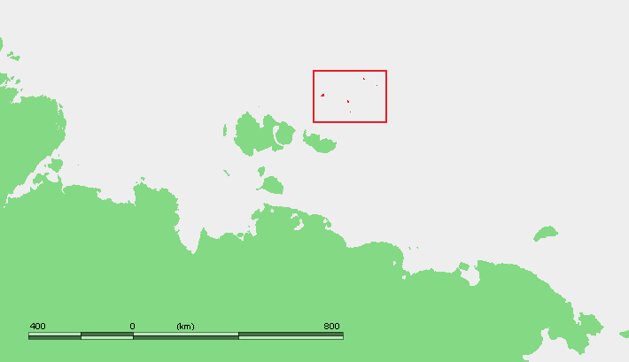
 Location of the De Long Islands.
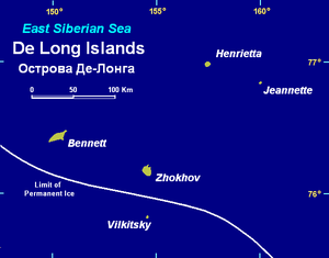 Map of the De Long group.
The De Long Islands (Sakha: Де Лоҥ арыылара, De Long arıılara; Russian: Острова Де-Лонга, Ostrova De-Longa) are an uninhabited archipelago often included as part of the New Siberian Islands, lying north east of Novaya Sibir. This archipelago consists of Jeannette Island, Henrietta Island, Bennett Island, Vilkitsky Island and Zhokhov Island. These five islands have a total area of 228 km². At 75 km², Bennett (Bennetta in Russian) Island is the largest island. These islands lie around 77°N, are partially covered by glaciers, and rise to peaks. In 1996, the total area of these islands covered by ice caps and glaciers was 80.6 km².[1] This island group belongs to the Sakha (Yakutia) Republic administrative division of Russia.
The De Long Islands were once major hills within the Great Arctic Plain that once formed the northern part of Late Pleistocene “Beringia” between Siberia and Alaska during the Last Glacial Maximum (Late Weichselian Epoch). These islands are what remains of about 1.6 million square kilometers of the formally subaerial Great Arctic Plain that now lies submerged below the Arctic Ocean and East Siberian Sea. At this plain's greatest extent during the Last Glacial Maximum, sea level was 100-120 m below modern sea level and the coastline was located 700-1000 kilometers north of its current position. This plain was neither extensively glaciated during the Late Pleistocene nor during the Last Glacial Maximum because it lay in the rain shadow of the Northern European ice sheet. The Great Arctic Plain was submerged, except for the New Siberian and other isolated islands, within a relatively short time span of 7,000 years during the Early-Middle Holocene.[2][3][4]
During the extremely frigid polar climate of the Last Glacial Maximum (Late Weichselian Epoch), 17,000 to 24,000 BP, small passive ice caps did form on the De Long Islands. Fragments of these ice caps are preserved on Jeannette, Henrietta, and Bennett Islands. Traces of former Late Weichselian slope and cirque glaciers in the form of buried ground ice deposits are preserved on Zhokhov Island.[2][4][5]
Geology
Early Paleozoic, Middle Paleozoic, Cretaceous, and Neogene rocks have been mapped within the De Long Islands. The Early Paleozoic rocks are Cambrian and Ordovician sedimentary rocks interbedded with minor amounts of limestone. The Middle Paleozoic rocks consist of predominately folded and faulted basaltic, andesitic, and dioritic volcanoclastics, tuffs, lavas, dikes, and sills. Cretaceous rocks are composed of basalts and interbedded argillites, sandstones and minor coals. The youngest rocks exposed within the De Long Islands are Neogene basaltic volcanic rocks.[6][7]
History
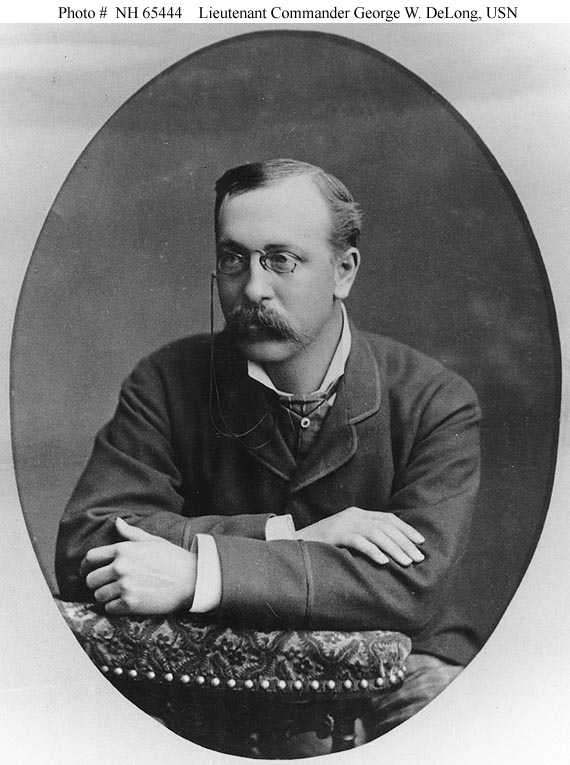
Jeannette Island, Henrietta Island, and Bennett Island were discovered in 1881 by the ill-fated Jeannette expedition, commanded by Lieutenant Commander George W. DeLong, USN. De Long claimed these islands for the U.S.[8] The United States Department of State has asserted that claim has never been made by the United States to any of the islands, and the US recognizes it as Russian territory. [9] though the United States Department of the Navy has asserted that Henrietta Island had been possessed.[10] During 1916 the Russian ambassador in London issued an official notice to the effect that the Imperial government considered these islands were integral parts of the Russian Empire. This territorial claim was later maintained by the Soviet Union. A resolution of the Alaska State Senate in 1988 supported an American claim to the islands, but during 1994 the Alaska State Supreme Court ruled in D. Denardo v. State of Alaska that Bennett Island, along with several islands, is not part of Alaska. [11]
In August 1901 Russian Arctic ship Zarya headed across the Laptev Sea, searching for the legendary Sannikov Land (Zemlya Sannikova) but was soon blocked by floating pack ice in the New Siberian Islands. During 1902 the attempts to reach Sannikov Land, deemed to be beyond the De Long Islands, continued while Zarya was trapped in fast ice. Leaving the ship, Russian Arctic explorer Baron Eduard Toll and three companions vanished forever in November 1902 in the while travelling away from Bennett Island towards the south on loose ice floes.
Vilkitsky Island (East Siberian Sea) and Zhokhov Island were discovered by Boris Vilkitsky during the Imperial Russian Arctic Ocean Hydrographic Expedition he led in 1913 and 1914 respectively. They lie slightly further south (around 76°N), are unglaciated, and lower lying.
Henrietta was the site of a research station from 1937 to 1963.[12]
References
- ^ Glazovskiy, A.F., 1996, Russian Arctic. in J. Jania and J.O. Hagen, eds. Mass Balance of Arctic Glaciers. International Arctic Science Committee (Working Group on Arctic Glaciology) Report No. 5, Faculty of Earth Sciences University of Silesia, Sosnowiec-Oslo, Norway. 62 pp.
- ^ a b Anisimov, M.A., and V.E. Tumskoy, 2002, Environmental History of the Novosibirskie Islands for the last 12 ka. 32nd International Arctic Workshop, Program and Abstracts 2002. Institute of Arctic and Alpine Research, University of Colorado at Boulder, pp 23-25.
- ^ Schirrmeister, L., H.-W. Hubberten, V. Rachold, and V.G. Grosse, 2005, Lost world - Late Quaternary environment of periglacial Arctic shelves and coastal lowlands in NE-Siberia. 2nd International Alfred Wegener Symposium Bremerhaven, October, 30 - November 2, 2005.
- ^ a b Alekseev, M.N., 1997, Paleogeography and geochronology in the Russian eastern Arctic during the second half of the Quaternary. Quaternary International. vol. 41-42, pp. 11-15.
- ^ Makeyev, V.M., V.V. Pitul’ko, and A.K. Kasparov, 1992, The natural environment of the De Long Archipelago and ancient man in the Late Pleistocene and Early Holocene. Polar Geography and Geology. vol. 17, no. 1, pp. 55-63.
- ^ Kos’ko, M.K., 1992, Major tectonic interpretations and constraints for the New Siberian Islands region, Russia Arctic. 1992 Proceedings International Conference on Arctic Margins, International Conference on Arctic Margins, US Marine Management Service, Alaska Region, Anchorage, Alaska, pp. 195-200.
- ^ Kos’ko, M.K., and G.V. Trufanov, 2002, Middle Cretaceous to Eopleistocene Sequences on the New Siberian Islands: an approach to interpret offshore seismic. Marine and Petroleum Geology. vol. 19, no. 7, pp. 901–919.
- ^ De Long, George Washington, 1883, The Voyage of the Jeannette. Boston: Houghton, Mifflin and Company.
- ^ Bureau of European and Eurasian Affairs, 2003, US State Department Fact Sheet. Washington, DC
- ^ Secretary of the Navy, 1882, The Jeannette Expedition in Report of the Secretary of the Navy, for the Year 1882. US Government Printing Office, Washington, DC
- ^ The Alaska Legal Resource Center, nd, D. Denardo v. State of Alaska (12/23/94), 887 P 2d 947
- ^ Headland, R. K.,1994, OSTROVA DE-LONGA ('De Long Islands'), Scott Polar Research Institute
 Islands of the East Siberian Sea (Russian Arctic)Anzhu Islands • Ayon Island • Bennett Island • Bolshoy Fedorovskiy • Chengkuul • De Long Islands • Glavsevmorput Island • Bolshoy Lyakhovsky Island • Henrietta Island • Jeannette Island • Kolesovsky Island • Kolesovskaya Otmel • Kotelny • Krestovyy Island • Maly Lyakhovsky Island • Medvezhyi Islands • Mikhalkino • New Siberian Islands • Novaya Sibir • Ploskiy • Routan Islands • Ryyanranot • Shalaurova • Sukhornyy • Uparovskiy • Usun Ary • Vilkitsky • Vkhodnoy • Wrangel Island • Zhokhov IslandCategories:

Wikimedia Foundation. 2010.