- Medvezhyi Islands
-
Coordinates: 70°52′N 161°26′E / 70.867°N 161.433°E
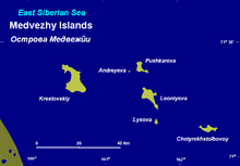

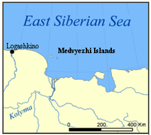
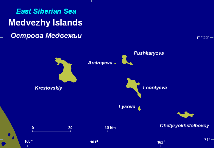
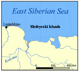
The Medvezhyi Islands, or Bear Islands (Russian: Медве́жьи острова́; Sakha: Эhэлээх арыылар, Eheleex Arıılar) is an uninhabited group of islands at the western end of the Kolyma Gulf of the East Siberian Sea. It is located about 100 kilometres (62 mi) to the north of the mouths of the Kolyma River. The coast of Siberia is about 35 kilometres (22 mi) to the southwest of the largest island, which is about 15 kilometres (9.3 mi) km long. The islands of this island group are covered with tundra vegetation.
The sea surrounding the Medvezhyi Islands is covered with fast ice in the winter and the climate is severe. The surrounding sea is obstructed by pack ice even in the summer months. There is commercial fishing in the area of the islands during the summer.[1]
This island group is a part of the territory of the Sakha Republic of Russia. As their name indicates, these islands are a refuge and breeding ground for polar bears.
History
The first recorded European to report the existence of the Medvezhyi Islands was Russian explorer Yakov Permyakov in 1710. While sailing from the Lena to the Kolyma River, Permyakov observed the silhouette of the unknown island group in the then little explored East Siberian Sea.
In 1820-1824, during Ferdinand Wrangel's Arctic expedition to the East Siberian Sea and the Chukchi Sea, Arctic explorer Fyodor Matyushkin surveyed and mapped Chetyryokhstolbovoy Island in the Medvezhyi group.
On September 3, 1878, Adolf Erik Nordenskiöld recorded that he sailed close to the island group in the steamship Vega. This was during the famous expedition that made the whole length of the Northeast passage for the first time in history.
References
- Geography
- The Arctic Ocean Hydrographic Expedition 1910-1915
- Albert Hastings Markham. Arctic Exploration, 1895
See also
 Islands of the East Siberian Sea (Russian Arctic)Anzhu Islands • Ayon Island • Bennett Island • Bolshoy Fedorovskiy • Chengkuul • De Long Islands • Glavsevmorput Island • Bolshoy Lyakhovsky Island • Henrietta Island • Jeannette Island • Kolesovsky Island • Kolesovskaya Otmel • Kotelny • Krestovyy Island • Maly Lyakhovsky Island • Medvezhyi Islands • Mikhalkino • New Siberian Islands • Novaya Sibir • Ploskiy • Routan Islands • Ryyanranot • Shalaurova • Sukhornyy • Uparovskiy • Usun Ary • Vilkitsky • Vkhodnoy • Wrangel Island • Zhokhov IslandCategories:
- Islands of Russia
- Islands of the East Siberian Sea
- Sakha Republic
Wikimedia Foundation. 2010.