- Cliviger
-
Coordinates: 53°45′54″N 2°12′22″W / 53.765°N 2.206°W
Cliviger 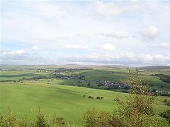
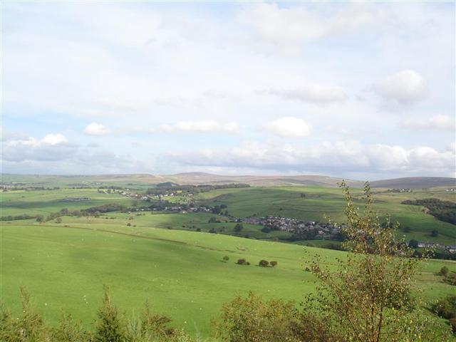
A view over Cliviger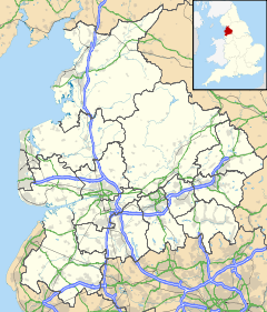
 Cliviger
Cliviger shown within LancashirePopulation 2,350 (2001) OS grid reference SD864299 Parish Cliviger District Burnley Shire county Lancashire Region North West Country England Sovereign state United Kingdom Post town BURNLEY Postcode district BB10 Dialling code 01282 Police Lancashire Fire Lancashire Ambulance North West EU Parliament North West England UK Parliament Burnley List of places: UK • England • Lancashire Cliviger is a civil parish within the Borough of Burnley, in Lancashire, England. It is situated to the southeast of Burnley, and northwest of Todmorden and has a population of 2,350.[1] Although the whole parish lies within the Borough of Burnley it is actually split between three postal towns, with a few farms lying in either Todmorden or Bacup postal towns.
Nowadays, it is mainly a dormitory area for people working in Burnley.
Contrary to popular (and in some cases mistaken local) belief there is no village of "Cliviger". The principal settlements within the parish are Walk Mill, Southward Bottom, Overtown, Mereclough and Holme Chapel.
Contents
History
See also: History of LancashireThere is some conjecture as to the origin of the name, but it is popularly thought to have Saxon origins and means 'sloping acre'.[citation needed]. The most likely explanation though is that Cliviger is derived from "Clivacher", a name which first appears in 1152 when Henry de Lacy gifted the land to Kirkstall Abbey. Neither Clivercher, Clivacher nor Cliviger are mentioned in the Domesday survey. The name Clivacher is closely associated with a steward of the de Lacys, Gilbert de Clivacher; however the last known member of the family was Cecilia de Clivacher who died shortly before the accession of Edward I to the throne of England. After that the name becomes extinct.
During the mid-eighteenth century, it produced worsted pieces for the neighbouring town of Burnley. An annual event is the Holme Sheep Fair, which is said to be one of the oldest village fairs in England.[citation needed]
St John the Divine Church in Holme Chapel was built in 1787 by Rev. Dr. Thomas Dunham Whitaker who was vicar of the parish from 1796 to 1821. The churchyard is the resting place of James Yorke Scarlett, a British General in the Crimean War, famous for leading the charge of the Heavy Brigade. The chapel also contains two 15th century misericords, which probably originated at Whalley Abbey
Governance
Cliviger Parish Council consists of 9 councillors who serve a 4 year term of office, with council meetings held once a month.[2] It is also part of the Cliviger with Hurstwood ward of Burnley Borough Council, along with the neighbouring parish of Worsthorne with Hurstwood. Currently represented by Michael Tattersall, David Heginbotham, and Cosima Towneley [3] (all of whom also serve on the parish council and are affiliated with the Conservative Party). And it is also part of the 'Burnley Rural' seat of Lancashire County Council.
Cliviger is made up of five enumeration districts named Mereclough, Overtown, Walk Mill, Southward Bottom and Holme Chapel, the last being regarded as the village centre, with a Primary School (St John The Divine C.E.Primary school), the church and the village hall.
Geography
The parish is located at the northwestern entrance to Cliviger Gorge, which extends southeast to the (now) West Yorkshire town of Todmorden. It is regarded as a remarkable example of a glacial valley[4] that follows a fault line cutting through the South Pennine Moors.
The valley was formerly a major transport link between Lancashire and Yorkshire, both the A646 road and a railway line pass through it (there was previously a railway station at Holme Chapel). However a road called ‘the long causeway’ which runs above the valley (passing Coal Clough Wind Farm), is believed to be ancient in its origins, possibly dating back to the Bronze Age.[5]
The parish contains the sources of the Lancashire River Calder, the West Yorkshire river with the same name, and the River Irwell. It lies astride the main watershed of Great Britain, as the Lancashire Calder and the Irwell flow west (via the rivers Ribble and Mersey respectively) to the Irish Sea, whilst the Yorkshire Calder flows east (via the Aire, then Ouse) into the North Sea.
People
The parish is the historical home of the Whitaker family, possibly the most notable being 16th century theologian William Whitaker. Ormerod House was the home of the Thursby family - notable members include General James Yorke Scarlett, commander of the so-called "Heavy Brigade" during the Crimean War; and also the mother of Korvettenkapitan Peter-Erich Cremer, one of the most decorated U-boat aces of the Second World War (and ultimately adjutant to Grand Admiral Karl Doentiz), was a Thursby.
- Jerry Dawson - Long serving Burnley goalkeeper was born here
- Colin Waldron - Former Burnley defender lives here[6]
- Frank Casper - Former Burnley player and manager has also lived here[7]
- Chris Casper - Former Manchester United and Reading footballer and manager of Bury, son of Frank Casper, was brought up in Cliviger.
- John McArdle - The Liverpool-born "Brookside" actor lives in Cliviger.
References
- ^ .Office for National Statistics : Census 2001 : Parish Headcounts : Burnley Retrieved 4 February 2010
- ^ Cliviger Parish Website Accessed 2010
- ^ Burnley Council Accessed 2010
- ^ West Yorkshire Geology Trust Accessed 2010
- ^ The AA Accessed 2010
- ^ This is Lancashire (news archive) Accessed 2010
- ^ Burnley Express Accessed 2010
External links
Ceremonial county of Lancashire North West England Portal Unitary authorities Boroughs or districts Major settlements Accrington • Adlington • Bacup • Barnoldswick • Blackburn • Blackpool • Brierfield • Burnley • Burscough • Carnforth • Chorley • Clayton-le-Moors • Cleveleys • Clitheroe • Colne • Darwen • Earby • Fleetwood • Garstang • Great Harwood • Haslingden • Kirkham • Lancaster • Leyland • Longridge • Lytham St Annes • Morecambe • Nelson • Ormskirk • Oswaldtwistle • Padiham • Penwortham • Poulton-le-Fylde • Preesall • Preston • Rawtenstall • Rishton • Skelmersdale • Wesham • Whitworth
See also: List of civil parishes in LancashireRivers Canals Topics Categories:- Districts in Burnley
- Villages in Lancashire
- Civil parishes in Lancashire

Wikimedia Foundation. 2010.