- Orange (NJT station)
-
Orange 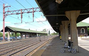
Eastbound platformStation statistics Lines Connections NJT Bus: 21, 41, 71, 73, 79, and 92
Community Coach: 77
ONE Bus: 24, 44Platforms 2 side platforms Tracks 3 Bicycle facilities Y Other information Owned by New Jersey Transit Fare zone 4[1] Traffic Passengers (2010) 1,143 (average weekday)  0.7%
0.7%Services Preceding station NJ Transit Rail Following station toward GladstoneGladstone Branch toward HackettstownMorristown Line Delaware, Lackawanna and Western Railroad toward BuffaloMain Line toward HobokenOrange Station

Location: 73 Lincoln Ave., Orange, New Jersey Coordinates: 40°46′18″N 74°14′2″W / 40.77167°N 74.23389°WCoordinates: 40°46′18″N 74°14′2″W / 40.77167°N 74.23389°W Area: 4.5 acres (1.8 ha) Built: 1918 Architect: Nies,F. J. Architectural style: Renaissance Governing body: State MPS: Operating Passenger Railroad Stations TR NRHP Reference#: 84002665[2] Added to NRHP: June 22, 1984 Orange is a New Jersey Transit station in Orange, New Jersey along the Morris & Essex Lines (formerly Erie Lackawanna Railway). Service is available via the Kearny Connection to Secaucus Junction and Penn Station in Midtown Manhattan and to Hoboken Terminal. Passengers can transfer at Newark Broad Street or Summit to reach the other destination if necessary.
The brick station and nearby freight terminal was built in 1918, and has been on the National Register of Historic Places since 1984.[3]
See also
References
- ^ "Morris and Essex Timetables". Newark, New Jersey: New Jersey Transit Rail Operations. November 7, 2010. http://www.njtransit.com/pdf/rail/R0040.pdf. Retrieved November 27, 2010.
- ^ "National Register Information System". National Register of Historic Places. National Park Service. 2009-03-13. http://nrhp.focus.nps.gov/natreg/docs/All_Data.html.
- ^ Essex County Listings on the National Register of Historic Places (Building - #84002665)
External links
- NJT rail station information page for Orange
- DepartureVision real time train information for Orange
- Morris and Essex Line schedule (Morristown Line & Gladstone Branch)
U.S. National Register of Historic Places Topics Lists by states Alabama • Alaska • Arizona • Arkansas • California • Colorado • Connecticut • Delaware • Florida • Georgia • Hawaii • Idaho • Illinois • Indiana • Iowa • Kansas • Kentucky • Louisiana • Maine • Maryland • Massachusetts • Michigan • Minnesota • Mississippi • Missouri • Montana • Nebraska • Nevada • New Hampshire • New Jersey • New Mexico • New York • North Carolina • North Dakota • Ohio • Oklahoma • Oregon • Pennsylvania • Rhode Island • South Carolina • South Dakota • Tennessee • Texas • Utah • Vermont • Virginia • Washington • West Virginia • Wisconsin • WyomingLists by territories Lists by associated states Other Categories:- The Oranges, New Jersey
- New Jersey Transit stations
- Transportation in Essex County, New Jersey
- Railway stations opened in 1918
- Railway stations on the National Register of Historic Places in New Jersey
- Stations along Delaware, Lackawanna and Western Railroad lines
- Renaissance Revival architecture in the United States
- Buildings and structures completed in 1918
- New Jersey railway station stubs
- New Jersey Registered Historic Place stubs


Wikimedia Foundation. 2010.