- Bailey Island Bridge
-
Bailey Island Bridge
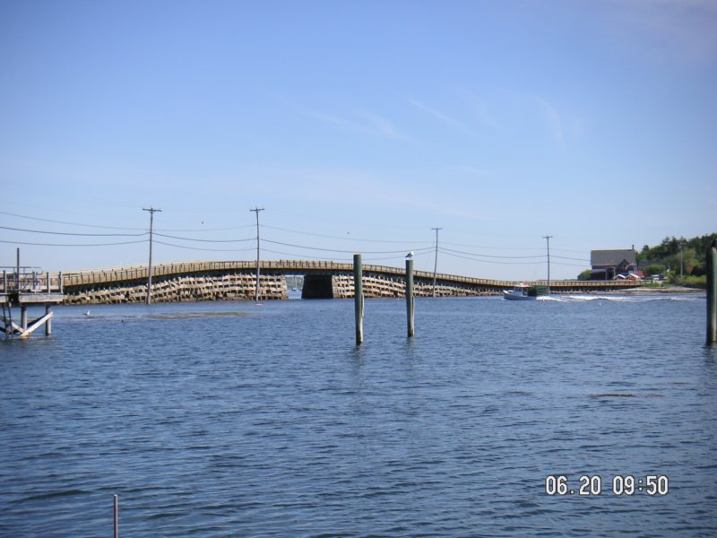
 Bailey Island Bridge from Bailey Island, looking toward Orr's Island
Nearest city: Harpswell, ME Coordinates: 43°44′57.8″N 69°59′18.6″W / 43.749389°N 69.9885°WCoordinates: 43°44′57.8″N 69°59′18.6″W / 43.749389°N 69.9885°W Built: 1928 Architectural style: Other Governing body: Local NRHP Reference#: 75000093 [1] Added to NRHP: April 28, 1975 The Bailey Island Bridge (also called the Cribstone Bridge) is a historic bridge in the town of Harpswell within Cumberland County in the state of Maine.
Contents
History
For many years, the residents of Bailey Island, Maine advocated that a bridge be built to connect their island with Orr's Island.[2] The town of Harpswell, Maine, which encompasses both islands, turned down the request. However, when the Maine Legislature drafted a law allowing the state and counties to fund bridge construction, a plan emerged to build such a bridge. A contract was signed in 1926, with construction beginning on the Bailey Island Bridge in 1927 and finishing in 1928. The engineer for the project was Llewelyn N. Edwards, bridge engineer for the Maine State Highway Commission.[2]
Design
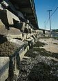
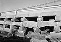
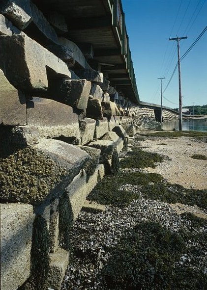
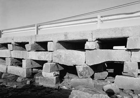
Design of the 1,150-foot bridge was complicated by the tides in the area known as Will's Gut. It was decided to build a cribstone bridge using granite slabs from local quarries on the border between Yarmouth, Maine and Pownal, Maine. Granite slabs were considered sufficiently heavy to withstand wind and wave, while the open cribbing allowed the tide to ebb and flow freely without increasing tidal current to any great degree. Some 10,000 tons of granite were used in the project. A concrete road (now part of Route 24) was built on top of the cribstones.
Additions and Recognition
A sidewalk was added in 1951 and guard rails in 1961. On July 19, 1984 the Bailey Island Bridge was recognized as a Historic Civil Engineering Landmark and was listed on the National Register of Historic Places in 1975. The Bailey Island Bridge is reported to be the only granite cribstone bridge in the world.[2]
In 2009 and 2010, the bridge underwent reconstruction to repair cracked or sheered stones.[3] During the repairs a 1,000 foot temporary bridge was placed alongside the cribstone bridge so that traffic could continue without disruption. On November 20, 2010, a ribbon-cutting ceremony and parade took place to celebrate the reopening of the bridge.[4] The restored bridge maintains the dimensions of the original, and the replacement stones were obtained from the same quarry in Yarmouth that supplied the original.
Photo gallery
-

Stone cribs along the side of the bridge
-

View of the bridge from the rocky shoreline
-

Close up of the water passage
-
Close up the stone base in color
-

Stone piles under the bridge
-
View of crib work and guard rails
See also
Notes
- ^ "National Register Information System". National Register of Historic Places. National Park Service. 2007-01-23. http://nrhp.focus.nps.gov/natreg/docs/All_Data.html.
- ^ a b c Hansen, Brett (January 2009). "Stacking Stones:The Bailey Island Bridge". Civil Engineering (Reston, Virginia: American Society of Civil Engineers) 79 (1): 34–35. ISSN 0885-7024. "Proposals were made many times in the 18th and 19th centuries to construct a bridge."
- ^ "Cribstone Bridge Undergoing Repairs". http://www.wcsh6.com/life/programming/local/bill_greens_maine/story.aspx?storyid=102362&catid=144.
- ^ Delage, Sarah (November 20, 2010). "Community celebrates historic bridge restoration". WCSH. http://www.wcsh6.com/news/story.aspx?storyid=137371. Retrieved 2010-11-20.
Sources
Further reading
- Maine Bridge History
- History of Bailey Island
- Kathleen Clemons Photography of Bailey Island Bridge
- Documentary video:The Cribstone Bridge,Explore Maine segment,(c)2007, Remember ME! Media,a 13 minute documentary clip describing the history and location of the bridge.http://remembermemedia.com/exme.html
Casco Bay Major Islands Peaks Island • Long Island • Cliff Island • Chebeague Island • Cushing Island • Great Diamond Island • Little Diamond Island • House IslandU.S. National Register of Historic Places Topics Lists by states Alabama • Alaska • Arizona • Arkansas • California • Colorado • Connecticut • Delaware • Florida • Georgia • Hawaii • Idaho • Illinois • Indiana • Iowa • Kansas • Kentucky • Louisiana • Maine • Maryland • Massachusetts • Michigan • Minnesota • Mississippi • Missouri • Montana • Nebraska • Nevada • New Hampshire • New Jersey • New Mexico • New York • North Carolina • North Dakota • Ohio • Oklahoma • Oregon • Pennsylvania • Rhode Island • South Carolina • South Dakota • Tennessee • Texas • Utah • Vermont • Virginia • Washington • West Virginia • Wisconsin • WyomingLists by territories Lists by associated states Other Categories:- Bailey Island (Maine)
- Buildings and structures in Cumberland County, Maine
- Bridges completed in 1928
- Bridges on the National Register of Historic Places in Maine
- Historic Civil Engineering Landmarks
- Transportation in Cumberland County, Maine
- Road bridges in Maine
-


Wikimedia Foundation. 2010.