- Harpswell, Maine
-
"Harpswell" redirects here. For the village in Lincolnshire, England, see Harpswell, Lincolnshire.
Harpswell, Maine — Town — Lookout Point Location within the state of Maine
 Harpswell, Maine
Coordinates: 43°47′9″N 69°57′27″W / 43.78583°N 69.9575°WCoordinates: 43°47′9″N 69°57′27″W / 43.78583°N 69.9575°W Country United States State Maine County Cumberland Incorporated 1758 Area – Total 83.9 sq mi (217.4 km2) – Land 24.2 sq mi (62.6 km2) – Water 59.7 sq mi (154.7 km2) Elevation 39 ft (12 m) Population (2000) – Total 5,239 – Density 216.7/sq mi (83.7/km2) Time zone Eastern (EST) (UTC-5) – Summer (DST) EDT (UTC-4) ZIP code 04079 Area code(s) 207 FIPS code 23-31390 GNIS feature ID 0582511 Website www.harpswell.maine.gov Harpswell is a town in Cumberland County, Maine, which is geographically within Casco Bay in the Gulf of Maine. The population was 5,239 at the 2000 census. Harpswell is composed of land contiguous with the rest of Cumberland County, called Harpswell Neck, as well as several large and small islands: Sebascodegan Island (locally known as Great Island), Orr's Island, and Bailey Island. Harpswell is part of the Portland–South Portland–Biddeford, Maine Metropolitan Statistical Area.
Contents
History
The Native Americans who originally inhabited Harpswell were part of the Abenaki. The Abenaki name for Harpswell Neck, then called West Harpswell, was Merriconeag or "quick carrying place", a reference to the narrow peninsula's easy portage. The Abenaki name for Great Island was Erascohegan or Sebascodiggin,[1] which became by the late 1800s Sebascodegan Island. About 1659 Major Nicholas Shapleigh of Kittery, Maine, bought Merriconeag and Sebascodegan Island from the Abenaki, but because of Indian attacks, attempts to settle the area were abandoned until after Dummer's War. The Treaty of 1725 brought a truce and by 1731 many settlers had returned.[2]
In 1758 the town was incorporated by the Massachusetts General Court and named for Harpswell in Lincolnshire, England.[3] Industries included farming and some shipbuilding, but fishing brought considerable profit. Because of its scenic beauty, Harpswell is today a favorite with artists and tourists. The Bailey Island Bridge is an Historic Civil Engineering Landmark.
Geography
According to the United States Census Bureau, the town has a total area of 83.9 square miles (217 km2), of which, 24.2 square miles (63 km2) of it is land and 59.8 square miles (155 km2) of it (71.20%) is water. The town is situated on Casco Bay in the Gulf of Maine, part of the Atlantic Ocean. Harpswell has about 216 miles of coast, more than any other town in the United States.
The town is crossed by state routes 24 and 123. It borders the town of Brunswick to the north, and is separated by the New Meadows River from West Bath to the northeast, and Phippsburg to the east.
Demographics
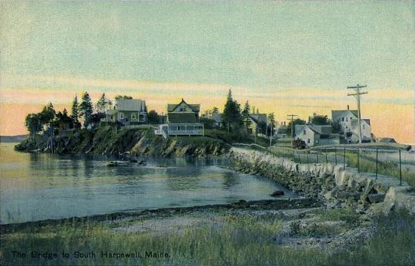
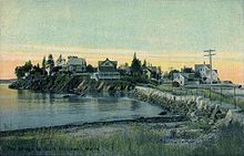 The bridge and causeway to South Harpswell in 1914
As of the census[4] of 2000, there were 5,239 people, 2,340 households, and 1,532 families residing in the town. The population density was 216.7 people per square mile (83.7/km²). There were 3,701 housing units at an average density of 153.1 per square mile (59.1/km²). The racial makeup of the town was 97.94% White, 0.25% African American, 0.34% Native American, 0.55% Asian, 0.23% from other races, and 0.69% from two or more races. Hispanic or Latino of any race were 1.32% of the population.
There were 2,340 households out of which 24.0% had children under the age of 18 living with them, 56.1% were married couples living together, 6.3% had a female householder with no husband present, and 34.5% were non-families. 27.3% of all households were made up of individuals and 10.9% had someone living alone who was 65 years of age or older. The average household size was 2.24 and the average family size was 2.69.
 Ragged Island in c. 1920
In the town the population was spread out with 19.6% under the age of 18, 4.9% from 18 to 24, 25.1% from 25 to 44, 31.7% from 45 to 64, and 18.8% who were 65 years of age or older. The median age was 45 years. For every 100 females there were 96.1 males. For every 100 females age 18 and over, there were 93.3 males.
The median income for a household in the town was $40,611, and the median income for a family was $45,119. Males had a median income of $34,167 versus $30,000 for females. The per capita income for the town was $30,433. About 3.3% of families and 5.6% of the population were below the poverty line, including 6.8% of those under age 18 and 3.8% of those age 65 or over.
Notable people
- Robert P. T. Coffin, author, poet.[citation needed]
- Patrick Dempsey, actor.
- Stephen M. Etnier, artist.
- Elijah Kellogg, minister, lecturer, author.
- Edna St. Vincent Millay, poet.[5]
- James L. Nelson, novelist.
- Robert Peary, explorer.
- Harriet Beecher Stowe, author.[citation needed]
- Mark Rogers, baseball pitcher.
Education
Public schools in the area are operated by Maine School Administrative District 75. During the 2010-11 school year, Harpswell residents voted to close the West Harpswell School, one of the town's two K-5 elementary schools. Beginning in 2011-12, West Harpswell students will be bused to the Harpswell Islands School. It was due to save approximately $200,000 a year.[6]
Sites of interest
- Eagle Island State Historic Site
- Harpswell Historical Society Museum
- Ragged Island - Summer home of Edna St. Vincent Millay
References
- ^ History of Harpswell, Maine From A Gazetteer of the State of Maine By Geo. J. Varney Published by B. B. Russell, 57 Cornhill, Boston 1886 [1]
- ^ Coolidge, Austin J.; John B. Mansfield (1859). A History and Description of New England. Boston, Massachusetts. pp. 153–154. http://books.google.com/books?id=OcoMAAAAYAAJ&lpg=PA9&dq=coolidge%20mansfield%20history%20description%20new%20england%201859&pg=PA153#v=onepage&q&f=false.
- ^ Maine League of Historical Societies and Museums (1970). Doris A. Isaacson. ed. Maine: A Guide 'Down East'. Rockland, Me: Courier-Gazette, Inc.. pp. 312–316.
- ^ "American FactFinder". United States Census Bureau. http://factfinder.census.gov. Retrieved 2008-01-31.
- ^ Milford, Nancy. Savage Beauty: The Life of Edna St. Vincent Millay. Random House, 2001. Print. p. 269
- ^ Harpswell votes to close one of its elementary schools Portland Press Herald, 1 February 2011
Further reading
- History of Brunswick, Topsham, and Harpswell, Maine Including Ancient Pejepscot. By George Augustus Wheeler and Henry Warren Wheeler. Published 1878. Full image at books.google.
- Pejepscot Historical Society (official website)
External links
- Town of Harpswell, Maine
- Harpswell Business Association
- Curtis Library (regional)
- Orr's Island Library
- Cundy's Harbor Library
- Harpswell Historical Society
- Maine.gov -- Harpswell, Maine
- Maine Genealogy: Harpswell, Cumberland County, Maine
Municipalities and communities of Cumberland County, Maine Cities 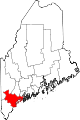
Towns Baldwin | Bridgton | Brunswick | Cape Elizabeth | Casco | Chebeague Island | Cumberland | Falmouth | Freeport | Frye Island | Gorham | Gray | Harpswell | Harrison | Long Island | Naples | New Gloucester | North Yarmouth | Pownal | Raymond | Scarborough | Sebago | Standish | Windham | Yarmouth
CDPs Other
villageCategories:- Towns in Cumberland County, Maine
- Portland – South Portland – Biddeford metropolitan area
- Harpswell, Maine


Wikimedia Foundation. 2010.