- Standish, Maine
Infobox Settlement
official_name = Standish, Maine
settlement_type = Town
nickname =
motto =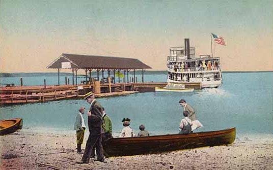
imagesize =
image_caption = Steamboat leaving Sebago Lake Station
image_|pushpin_
pushpin_label_position =left
pushpin_map_caption =Location within the state of Maine
pushpin_mapsize =
|mapsize =
map_caption =
mapsize1 =
map_caption1 =subdivision_type = Country
subdivision_name =United States
subdivision_type1 = State
subdivision_name1 =Maine
subdivision_type2 = County
subdivision_name2 = Cumberland
government_footnotes =
government_type =
leader_title =
leader_name =
leader_title1 =
leader_name1 =
established_title = Incorporated
established_date = 1785unit_pref = Imperial
area_footnotes =area_magnitude =
area_total_km2 = 216.8
area_land_km2 = 153.0
area_water_km2 = 63.8
area_total_sq_mi = 83.7
area_land_sq_mi = 59.1
area_water_sq_mi = 24.6population_as_of = 2000
population_footnotes =
population_total = 9285
population_density_km2 = 60.7
population_density_sq_mi = 157.2timezone = Eastern (EST)
utc_offset = -5
timezone_DST = EDT
utc_offset_DST = -4
elevation_footnotes =
elevation_m = 87
elevation_ft = 285
latd = 43 |latm = 45 |lats = 42 |latNS = N
longd = 70 |longm = 33 |longs = 52 |longEW = Wpostal_code_type =
ZIP code
postal_code = 04084
area_code = 207
blank_name = FIPS code
blank_info = 23-73670
blank1_name = GNIS feature ID
blank1_info = 0582744
website =
footnotes =Standish is a town in Cumberland County,
Maine ,United States . The population was 9,285 at the 2000 census. It includes the villages of Standish Corner, Sebago Lake Village and Steep Falls, and the localities known as Richville, Standish Neck and Two Trails. Standish is part of the Portland-South Portland-Biddeford, Maine Metropolitan Statistical Area.History
This was once hunting and fishing territory of the Sokokis
Abenaki Indians, whose main village was at Pequawket (now Fryeburg) up the Pequawket Trail (Route 113). In 1750, theMassachusetts General Court granted the township to Captain Moses Pearson and Captain Humphrey Hobbs, together with their respective companies, for services during theFrench and Indian Wars . It was to be called Pearson and Hobbs Town, but Hobbs died and none of his company took possession. In 1752, the land was surveyed and divided into 30 acre lots, although some soldiers sold their rights for whatever they could get. Those that did settle found their cabins razed by Indians trying to drive them away. In response, the veterans built at Standish Corner astockade d fort, which provided protection until Indian hostilities ceased in 1759 with theFall of Quebec . Pearsontown Plantation was incorporated as Standish onNovember 30 ,1785 . cite book |last= Maine League of Historical Societies and Museums |editor=Doris A. Isaacson |title=Maine: A Guide 'Down East' |year=1970 |publisher=Courier-Gazette, Inc. |location=Rockland, Me | pages = 410 ] cite web |title=Maine Local Government - Town of Standish |url=http://www.maine.gov/local/cumberland/standish/ |accessdate=2007-01-14] The town is named in honor of Captain Myles Standish.Much of Standish is sandy plains covered with
pine , yetfarmer s found considerablearable land .Watermill s at various streams producedlumber , headings, shooks, barrel staves,carriage s,clothing ,flour ,ice ,plaster and packing boxes. TheCumberland and Oxford Canal opened in 1832, increasing trade betweenSebago Lake and Portland. It was followed by thePortland and Ogdensburg Railroad , which onSeptember 12 ,1870 began regular passenger service between Portland and Sebago Lake Station. Tourists could arrive bytrain in the morning, ride a side-wheelsteamboat the whole length of the lakes, then return to the city by evening. The cost of the excursion in 1876 was $1.75 from Portland to Naples, and $2.00 from Portland to Bridgton, North Bridgton or Harrison. Standish also hadrailroad depot s at Richville and Steep Falls. In 1998, Frye Island in Sebago Lake was set off and incorporated as a separate town. Today, Standish is both a recreational area and suburb of Portland.Notable residents
*
Simon M. Hamlin , congressman
*Albion P. Howe , generalGeography
According to the
United States Census Bureau , the town has a total area of 83.7 square miles (216.8 km²), of which, 59.1 square miles (153.0 km²) of it is land and 24.6 square miles (63.8 km²) of it (29.42%) is water. Situated besideSebago Lake , Standish is drained by theSaco River , which is the town's (and Cumberland County's) southwestern border.The town is crossed by state routes 11, 25, 25A, 35, 35A, 114 and 237. It borders the towns of Windham and Gorham to the southeast, Buxton and Hollis to the south, Limington to the west, and Baldwin and Sebago to the northwest.
Demographics
As of the
census GR|2 of 2000, there were 9,285 people, 3,205 households, and 2,464 families residing in the town. Thepopulation density was 157.2 people per square mile (60.7/km²). There were 3,987 housing units at an average density of 67.5/sq mi (26.1/km²). The racial makeup of the town was 98.08% White, 0.39% African American, 0.16% Native American, 0.24% Asian, 0.08% Pacific Islander, 0.23% from other races, and 0.83% from two or more races. Hispanic or Latino of any race were 0.46% of the population.There were 3,205 households out of which 37.0% had children under the age of 18 living with them, 64.0% were married couples living together, 8.9% had a female householder with no husband present, and 23.1% were non-families. 16.7% of all households were made up of individuals and 6.0% had someone living alone who was 65 years of age or older. The average household size was 2.72 and the average family size was 3.03.
In the town the population was spread out with 25.3% under the age of 18, 13.1% from 18 to 24, 30.5% from 25 to 44, 23.0% from 45 to 64, and 8.2% who were 65 years of age or older. The median age was 34 years. For every 100 females there were 94.4 males. For every 100 females age 18 and over, there were 90.4 males.
The median income for a household in the town was $50,278, and the median income for a family was $53,461. Males had a median income of $36,235 versus $26,204 for females. The
per capita income for the town was $19,504. About 1.9% of families and 3.6% of the population were below thepoverty line , including 3.8% of those under age 18 and none of those age 65 or over.Education
*
Bonny Eagle High School is a publichigh school serving the towns of Buxton, Hollis, Limington and Standish
*Saint Joseph's College of Maine has its campus in Standishites of interest
* Daniel Marrett House - the 1789 home of the town's
parson located in town center, now aHistoric New England museum
* [http://oldredchurch.org/ The Old Red Church] - an 1804 meeting house, now a museum
* [http://schoolhousearts.org/ Schoolhouse Arts Center at Sebago Lake]
* [http://www.museumsusa.org/museums/info/1158785 Standish Historical Society & Museum]References
Further reading
* [http://history.rays-place.com/me/standish-me.htm History of Standish, Maine (1886)]
* A. J. Coolidge & J. B. Mansfield, "A History and Description of New England", 1859; H. O. Houghton & Company, printers; Cambridge, MassachusettsExternal links
* [http://www.standish.org/ Town of Standish, Maine]
* [http://www.steepfallslibrary.org/ Steep Falls Public Library]
* [http://www.maine.gov/local/cumberland/standish Maine.gov -- Standish, Maine]
* [http://city-data.com/city/Standish-Maine.html City-Data.com profile]

Wikimedia Foundation. 2010.