- North Central Texas Council of Governments
-
North Central Texas Council of Governments 
LogoLocation 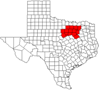
General Information Established January 1966 Number of Counties 16 Area (approx.) 12,800 sq. mi. Population [1] 5,309,277 (2000)
6,649,214 (2010)The North Central Texas Council of Governments or NCTCOG is a voluntary association of governments in the Dallas/Fort Worth Metroplex. Its ranks currently include 230 member governments including 16 counties, numerous cities, school districts, and special districts. [2] Based in Arlington, the North Central Texas Council of Governments is a member of the Texas Association of Regional Councils.
Contents
Purpose
The purpose of NCTCOG is to "strengthen both the individual and collective power of local governments and to help them recognize regional opportunities, eliminate unnecessary duplication, and make joint decisions." [2]
Organization
Each member government appoints a representative from its governing body to the COG General Assembly. This group meets annually to elect the Executive Board, a policy-making body for all NCTCOG activities composed of 13 officials. The activities organized include regional plans, program activities and decisions, and fiscal and budgetary policies. Within NCTCOG are technical, study, and policy development committees and a professional staff headed by Mike Eastland (the Executive Director) that support the Board. [2]
Counties served
Largest Cities in the region
Major Cities
City 2000 Population [3] 2009 Population [4] Dallas 1,188,580 1,306,350 Fort Worth 534,694 720,250 Arlington 332,969 370,450 Plano 222,030 263,800 Cities and towns 100k-250k
City/Town 2000 Population [3] 2009 Population [5] Garland 215,768 228,350 Irving 191,615 212,250 Grand Prairie 127,427 168,500 Mesquite 124,523 137,850 McKinney 54,369 121,850 Carrollton 109,576 120,950 Denton 80,537 107,250 Frisco 33,714 100,800 Cities and towns 25k-99k
City /Town 2000 Population [3] 2009 Population [6] Richardson 91,802 99,700 Lewisville 77,737 95,250 Allen 43,554 80,400 North Richland Hills 55,635 66,100 Flower Mound 50,702 62,800 Mansfield 28,031 55,950 Rowlett 44,503 54,250 Euless 46,005 54,200 Bedford 47,152 49,700 DeSoto 37,646 48,700 Grapevine 42,059 47,950 Cedar Hill 32,093 45,600 The Colony 26,531 40,100 Coppell 35,958 39,550 Haltom City 39,018 39,550 Keller 27,345 39,450 Duncanville 36,081 38,850 Hurst 36,273 38,750 Wylie 15,132 38,300 Lancaster 25,894 36,200 Burleson 20,976 34,350 Rockwall 17,976 32,100 Farmers Branch 27,508 31,100 Cleburne 26,005 30,400 Waxahachie 21,426 29,900 Southlake 21,519 26,650 Weatherford 19,000 26,650 Greenville 24,117 26,600 Corsicana 24,485 25,300 References
- ^ Total Population Estimates for Texas Councils of Governments - Texas State Data Center.
- ^ a b c NCTCOG.org - About. Retrieved 27 April 2006.
- ^ a b c "American FactFinder". United States Census Bureau. http://factfinder.census.gov. Retrieved 2008-01-31.
- ^ 2009 Population Estimates by City - North Central Texas Council of Governments. April 23, 2009. Retrieved June 12, 2009.
- ^ 2009 Population Estimates by City - North Central Texas Council of Governments. April 23, 2009. Retrieved June 12, 2009.
- ^ 2009 Population Estimates by City - North Central Texas Council of Governments. April 23, 2009. Retrieved June 12, 2009.
External links
- [1] - official website
Texas Association of Regional Councils Councils of Government Alamo Area · Ark-Tex · Brazos Valley · Capital Area · Central Texas · Coastal Bend · Concho Valley · Deep East Texas · East Texas · Heart of Texas · North Central Texas · Rio Grande · Texoma · West Central TexasRegional Planning Commissions Development Councils Association of Governments Councils Categories:

Wikimedia Foundation. 2010.