- Crosby, Merseyside
-
For other uses, see Crosby (disambiguation).
Coordinates: 53°29′14″N 3°02′03″W / 53.4872°N 3.0343°W
Crosby 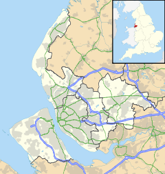
 Crosby
Crosby shown within MerseysidePopulation 51,789 OS grid reference SJ320999 Metropolitan borough Sefton Metropolitan county Merseyside Region North West Country England Sovereign state United Kingdom Post town LIVERPOOL Postcode district L23 Dialling code 0151 Police Merseyside Fire Merseyside Ambulance North West EU Parliament North West England UK Parliament Bootle Sefton Central List of places: UK • England • Merseyside Crosby is a town in the Metropolitan Borough of Sefton, in Merseyside, England. Historically part of Lancashire it is situated north of Bootle, south of Southport, Formby and west of Netherton
Contents
History
The town has Viking roots in common with the other -by suffixed settlements of Formby to the north and Kirkby to the east. Crosby was known as Krossabyr[1] in Old Norse, meaning "village with the cross".[2] The settlement was recorded in the Domesday Book of 1086 as Crosebi, and by the year 1212 had become Crosseby.[2]
The opening of the Liverpool, Crosby and Southport Railway in 1848 resulted in the growth of Crosby as suburb of Liverpool.
Governance
Crosby formed part of the Crosby parliamentary constituency from 1950 until 2010. The MP for Crosby from 1997 until 2010 was Claire Curtis-Thomas, a member of the Labour Party, prior to her election the seat was generally considered to be a safe Conservative Party stronghold with Tory MPs elected at every election barring the Crosby by-election, 1981 where Shirley Williams of the Social Democratic Party was elected to represent the constituency. As a result of boundary revisions for the 2010 general election the Crosby constituency was abolished and Crosby town was divided between two constituencies, with the two electoral wards of southern Crosby, Church and Victoria, containing the urbanised bulk of the town which includes the areas of Great Crosby, Waterloo and Seaforth, being absorbed into the expanded Bootle constituency, represented by the Labour MP Joe Benton, and the two electoral wards of northern Crosby, Blundellsands and Manor, which contains residential suburban areas such as, Blundellsands, Brighton-Le-Sands, Little Crosby, Thornton, and Hightown, forming part of the new Sefton Central constituency represented by Bill Esterson, also a Labour MP.
Administration
Crosby became part of the Municipal borough of Crosby in 1937 by the merger of the urban districts of Great Crosby and Waterloo with Seaforth, both in the administrative county of Lancashire. This borough was succeeded by the new Metropolitan Borough of Sefton in Merseyside on 1 April 1974.
For elections to Sefton Council Crosby's electoral ward is the Victoria ward, represented by three councillors. They are all members of the Liberal Democrats, they are Anthony Hill, Peter Hough, and Andrew Tonkiss.
Geography
Crosby as an area was composed of a string of settlements along the Irish Sea coast. These areas were part of the urban districts of Great Crosby and Waterloo with Seaforth and the Municipal Borough of Crosby before it to was abolished and became part of the Metropolitan Borough of Sefton. These areas are:
- Great Crosby - The main area which gave the town and the old municipal borough its name, despite the confusion that exists, Great Crosby is not the actual town itself but is the largest area of it which was a urban district in its own right which merged with Waterloo with Seaforth urban district to form the Municipal Borough of Crosby and defined the town of Crosby in its present borders.
- Little Crosby - A small village considered to be the oldest existent Roman Catholic village in England.
- Blundellsands - An area to the north west of Great Crosby, Considered to be very affluent with many local celebrities, footballers, politicians, businessmen and in general wealthy people making up the vast majority of residents calling this their home. It contains Crosby Beach, which is the location of Antony Gormley's Another Place.
- Waterloo - An area situated south west of Great Crosby close to Crosby Beach. It includes Crosby Civic Hall and Library, and also the Plaza Community Cinema. It contains Crosby Beach, which is the location of Antony Gormley's Another Place.
- Brighton-le-Sands - An area situated between Blundellsands to the north, Waterloo to the south and Great Crosby to the east.
- Thornton - A village Situated to the north east of Great Crosby.
Demography
Crosby compared 2001 UK census Crosby[3] Sefton (borough)[4] England Total population 51,789 282,958 49,138,831 White 98.4% 98.4% 91.0% Asian 0.5% 0.4% 4.6% Black 0.1% 0.2% 2.3% As of the 2001 UK census, Crosby had a population of 51,789. The 2001 population density was 12,502 inhabitants per square mile (4,827 /km2), with a 100 to 89.2 female-to-male ratio.[5] Of those over 16 years old, 31.2% were single (never married), 43.2% married and 8.2% divorced.[6] The proportion of divorced people was above that of Sefton and England (both 6.6%), and the rates of those who were single and married were significantly different to the national and Sefton averages (Sefton: 43.1% single, 35.5% married; England: 44.3% single, 34.7% married).[7] Sefton's 21,250 households included 32.7% one-person, 35.7% married couples living together, 6.6% were co-habiting couples, and 11.3% single parents with their children.[8] Of those aged 16–74, 28.1% had no academic qualifications, similar to 28.9% in all of England and slightly lower than the 31.0% for the Sefton borough.[9][10]
Education
Independent schools in the area include Merchant Taylors' Boys School, Merchant Taylors' Girls' School, St Mary's College and Streatham House. There are also several comprehensive schools, including Chesterfield High School, Holy Family Catholic High School, St. Michael's Church of England High School (formerly Manor High Secondary School) and Sacred Heart Catholic College (formerly Sacred Heart Catholic High School).
Places of interest
Crosby Beach is home to Anthony Gormley's art installation Another Place. The sea views were described in the 19th Century by the First Lord of the Admiralty as second only to the Bay of Naples.[11] Crosby's environs include several miles of beach, a marina, a number of parks and a large area of woodland known as Ince Woods. Crosby is home to a Carnegie Library built with donations from the American steel magnate Andrew Carnegie. Distinctive buildings in Crosby Village include Crown Buildings and the three pubs, The Crow's Nest, Yates's now known as the George again, and The Village.
Transport
Crosby is served by the railway stations of Hall Road, Blundellsands and Crosby, and Waterloo, on the Northern Line of the region's commuter rail network, Merseyrail. Trains run between Southport and Hunts Cross via Liverpool Central.
Sport
Marine AFC (Association football) and Waterloo RUFC (rugby union) are both based in the area. Crosby is also home to Crosby Swimming Club, a member of the Amateur Swimming Association (ASA).
The Northern Club, a multi-sport club featuring cricket, hockey, crown green bowls, squash, racketball and snooker, is set in the Moor Park area of Crosby.
Crosby Marina is the home of Crosby Sailing Club and is open to all dinghy sailors of any ability or experience. The marina is also a venue for the Crosby Scout and Guide Marina Club, who offer dinghy and kayak sailing to local youngsters.
Blundellsands Bridge Club [1], affiliated to the English Bridge Union, is based in the area and provides facilities for both learning and playing Rubber Bridge and Duplicate Bridge, an intellectual sport recognised by the International Mind Sports Association.
Notable people
- Kenny Everett
- J. Bruce Ismay
- Vincent Nichols
- Anne Robinson
- Robert Runcie
See also
References
- ^ "Wirral & West Lancashire 1100th Viking Anniversary". University of Nottingham. http://www.nottingham.ac.uk/~sczsteve/. Retrieved 14 February 2008.
- ^ a b "Formby Civic Society: Vikings In Lancashire". Stephen Harding. http://www.formbycivicsociety.org.uk/learning/full_article.asp?storyid=14. Retrieved 14 February 2008.
- ^ "KS06 Ethnic group: Census 2001, Key Statistics for urban areas". Statistics.gov.uk. 25 January 2005. http://www.statistics.gov.uk/statbase/ssdataset.asp?vlnk=8283&More=Y. Retrieved 2009-07-11.
- ^ "Sefton Local Authority ethnic group". Statistics.gov.uk. http://neighbourhood.statistics.gov.uk/dissemination/LeadTableView.do?a=7&b=276789&c=Sefton&d=13&e=16&g=360352&i=1001x1003x1004&o=1&m=0&r=1&s=1247275980992&enc=1&dsFamilyId=87. Retrieved 2009-07-11.
- ^ "KS01 Usual resident population: Census 2001, Key Statistics for urban areas". Statistics.gov.uk. 7 February 2005. http://www.statistics.gov.uk/statbase/ssdataset.asp?vlnk=8271&More=Y. Retrieved 2009-07-11.
- ^ "KS04 Marital status: Census 2001, Key Statistics for urban areas". Statistics.gov.uk. 2 February 2005. http://www.statistics.gov.uk/statbase/ssdataset.asp?vlnk=8276&More=Y. Retrieved 2009-07-11.
- ^ "Sefton Local Authority marital status". Statistics.gov.uk. http://neighbourhood.statistics.gov.uk/dissemination/LeadTableView.do?a=7&b=276789&c=Sefton&d=13&e=16&g=360352&i=1001x1003x1004&o=1&m=0&r=1&s=1247275981023&enc=1&dsFamilyId=83. Retrieved 2009-07-11.
- ^ "KS20 Household composition: Census 2001, Key Statistics for urban areas". Statistics.gov.uk. 2 February 2005. http://www.statistics.gov.uk/statbase/ssdataset.asp?vlnk=8349&More=Y. Retrieved 2009-07-11.
- ^ "Sefton Local Authority key statistics". Statistics.gov.uk. http://neighbourhood.statistics.gov.uk/dissemination/LeadKeyFigures.do?a=7&b=276789&c=Sefton&d=13&e=16&g=360352&i=1001x1003x1004&o=1&m=0&r=1&s=1247276900742&enc=1. Retrieved 2009-07-11.
- ^ "KS13 Qualifications and students: Census 2001, Key Statistics for urban areas". Statistics.gov.uk. 2 February 2005. http://www.statistics.gov.uk/statbase/ssdataset.asp?vlnk=8326&More=Y. Retrieved 2009-07-11.
- ^ Forwood, William Bower (1910). Recollections of a busy life. Liverpool: Henry Young & Sons. p. 166. http://www.archive.org/stream/recollectionsofb00forw#page/166/mode/2up.
External links
- Liverpool Street Gallery - Liverpool 23
- The Northern Club - multi-sport complex
- Crosby Scout and Guide Marina Club
- Titanic Town - Crosby's seafaring connections
- When Liverpool was Dixie - Crosby's links to the American Civil War
- The Crosby Herald online newspaper
- Blundellsands Bridge Club
Districts and wards of the Metropolitan Borough of Sefton Districts Ainsdale · Aintree · Birkdale · Blowick · Blundellsands · Bootle · Brighton-le-Sands · Carr Houses · Churchtown · Crosby · Crossens · Ford · Formby · Freshfield · Great Crosby · Hightown · Highpark · Hillside · Ince Blundell · Kennessee Green · Kew · Lady Green · Litherland · Little Altcar · Little Crosby · Lunt · Lydiate · Maghull · Marshside · Melling · Meols Cop · Netherton · Orrell · Seaforth · Sefton · Southport · Thornton · Waddicar · Waterloo · WoodvaleCouncil Wards Ceremonial county of Merseyside Metropolitan districts Major settlements Rivers Topics Categories:- Towns and villages in Sefton
- Towns in Merseyside
- Liverpool Urban Area


Wikimedia Foundation. 2010.