- Godmanchester
-
Coordinates: 52°19′03″N 0°10′21″W / 52.317616°N 0.172526°W
Godmanchester 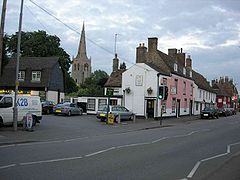
Post Street in Godmanchester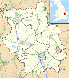
 Godmanchester
Godmanchester shown within CambridgeshirePopulation 5,500 (2001) OS grid reference TL245704 Parish Godmanchester District Huntingdonshire Shire county Cambridgeshire Region East Country England Sovereign state United Kingdom Post town HUNTINGDON Postcode district PE29 Dialling code 01480 Police Cambridgeshire Fire Cambridgeshire Ambulance East of England EU Parliament East of England UK Parliament Huntingdon List of places: UK • England • Cambridgeshire Godmanchester is a small town and civil parish within the Huntingdonshire district of Cambridgeshire, in England. It lies on the south bank of the River Great Ouse, south of the larger town of Huntingdon, and on the A14 road.
The town was on the site of the Roman town of Durovigutum.[1] It was first chartered by King John in 1212, though it had been a market town and royal manor for some years. There is archaeological evidence of Celtic and earlier habitation prior to the establishment of a key Roman town and a Mansio (inn), so the area has probably been continuously occupied for more than 2000 years. The settlement was at a crossroads of Roman roads, with Ermine Street, the Via Devana (from Cambridge, between Colchester and Chester) and a military road from Sandy, Bedfordshire, all passing through. The Roman settlement was sacked by Anglo-Saxons in the third century. In contrast to Huntingdon, there have been vast amounts of archaeological finds in the centre of Godmanchester, which has two conservation areas with a large number of timber-framed Tudor houses, the largest being Tudor Farm, dating from 1600 and restored in 1995.
 The Chinese Bridge
The mansio is mentioned in Godmanchester's name, which comes from Anglo-Saxon Godmundceaster, meaning a "town or Roman buildings associated with a man called Godmund". The location is likely to have been originally settled due to the gravel beds providing a ford across the River Great Ouse. In 2003 it had a population of about 5500 in 3500 homes, with the largest[2] increase in population occurring between 1981 and 1991 (81%) with more modest growth since.
There are several bridges across the Great Ouse to Huntingdon, but until 1975 Old Bridge, Huntingdon, a medieval bridge, was the only one. It is now used only for light traffic, and a parallel footbridge has been built for pedestrians. Construction of the A14 bypass means that heavy traffic now flows over a modern bridge.
One of the town's best-known features is its Chinese Bridge which connects Godmanchester with a water meadow. Local legend has it that the Chinese Bridge was built without the use of nails or any other fixings. A number of years later, an architect applied to the council for permission to deconstruct the bridge to discover how exactly this had been accomplished. This being done, they tried to reconstruct it, but found that they could not get it to support itself under its own weight. Today the Chinese Bridge is held together by nails. Of course this is false, as Cambridge has the same urban legend. More likely is that the original nails eroded away, giving the appearance that no nails existed. With maintenance work carried out in the latter part of the 20th century, nails would have been applied to strengthen the structure.
The bridge was removed by crane on Tuesday 9 February 2010. A new replica will be put into position on Monday 15th and Tuesday 16 February.
Between Godmanchester, Huntingdon and Brampton lies England's largest meadow, Portholme, which remains an important flood plain but which has served as a horse race course and centre for early aviation.
About a mile south of the town centre, on the A1198 road at grid reference TL260683 is the headquarters of the Wood Green Animal Shelters - a charity dedicated to rehoming unwanted pets.
Original historical documents relating to Godmanchester, including the original church parish registers, local government records, maps, photographs and the surviving borough charters, are held by Cambridgeshire Archives and Local Studies at the County Record Office Huntingdon.
References
- ^ Rivet, A.L.F.; Smith, Colin (1979). The Place-Names of Roman Britain. London. p. 354.
- ^ http://www.godmanchester.net/articles/population_figures.htm godmanchester.net
External links
- Community Web site with some 400 pages on Godmanchester
- Godmanchester Porch Museum
- Godmanchester Baptist Church
- Huntingdonshire District Council website for the town
- Godmanchester Community Association Web site featuring photo records in the 'scrapbook'
- The Roman Mansio in Godmanchester
River Great Ouse, England Counties Flows into Towns
(upstream to downstream)Brackley · Buckingham · Old Stratford · Milton Keynes (Stony Stratford • Wolverton • New Bradwell) · Newport Pagnell · Olney · Kempston · Bedford · St Neots · Godmanchester · Huntingdon · St Ives · Ely · Littleport · Downham Market · King's Lynn
Major tributaries
(upstream to downstream by confluence)River Tove · River Ouzel (or Lovat) · River Ivel · River Kym · Old Bedford River · New Bedford River · River Cam · River Lark · River Little Ouse · River Wissey
Major bridges
(upstream to downstream)Harrold bridge · A428 Turvey bridge · A428 Bromham bypass · A6 Bedford Town Bridge · A421 Bedford bypass · Great Barford Bridge · A428 Bridge St Neots · St Neots Town Bridge · Godmanchester Chinese Bridge · A14 bridge, River Great Ouse · Huntingdon Old Bridge · St Ives Bridge
Categories:- Towns in Cambridgeshire
- Populated places on the River Great Ouse
- Huntingdonshire
- Civil parishes in Cambridgeshire


Wikimedia Foundation. 2010.