- Cwmdare
-
Coordinates: 51°43′00″N 3°28′00″W / 51.716667°N 3.466667°W
Cwmdare Welsh: Cwmdâr 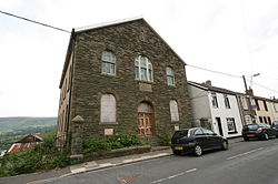
Elim Chapel, Bwllfa Road, Cwmdare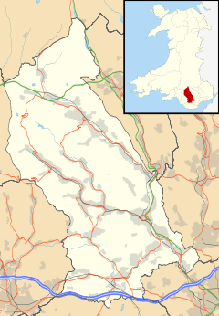
 Cwmdare
Cwmdare shown within Rhondda Cynon TaffPrincipal area Rhondda Cynon Taff Ceremonial county Mid Glamorgan Country Wales Sovereign state United Kingdom Police South Wales Fire South Wales Ambulance Welsh EU Parliament Wales UK Parliament Cynon Valley List of places: UK • Wales • Rhondda Cynon Taff Cwmdare (Welsh: Cwmdâr) is a village near Aberdare, in Rhondda Cynon Taf, Wales. The village's history is intertwined with coal-mining, and since the decline of the industry in the 1980s, it has become primarily a commuter base for the larger surrounding towns of Aberdare and Merthyr Tydfil and Pontypridd, as well as the cities of Cardiff and Swansea.
Contents
Name
The village's name literally translates as "Dare Valley". The Dare (Welsh: Dâr) is tributary that flows down from the Darren mountain, down through the village and on to Aberdare (literally "Mouth Of The Dare"), where it joins the larger River Cynon, one of the largest tributaries of the River Taff.
History
Before the exploitation of the South Wales Coalfield, Cwmdare was a scattering of a few houses and farms. However, in the 1850s with the Industrial Revolution fuelling the demand for coal, several deep coal mines were constructed in the area, and workers began to migrate there from other parts of Wales, as well as the South West of England.
The influx of miners naturally necessitated the construction of housing to support them, and between 1853 and 1859, the first streets were laid down on the west side of the Dare Valley, which would become the centre of the village of Cwmdare. At the same time, a small collection of houses were constructed on the east side of the valley, near the Merthyr Dare Colliery, known as Pithead. As the collieries grew over the next century, Cwmdare grew with it, with rows of terraced miner's cottages being built to the north-west of the original hamlet to create homes for the expanding workforce.
Cwmdare had four large collieries in operation during its history, all of which had closed by 1977. The Cwmdare, Merthyr Dare and Bwllfa Dare collieries were all sunk in the 1850s, while work began on the Nantmelin site in 1860. Over the next 120 years, the seams in the Maerdy mountain were gradually used up, with Merthyr Dare closing in 1884, Cwmdare in 1936, Nantmelin in 1957, and finally Bwllfa Dare in 1977.
Post-mining changes
Following the closure of the mines and the decline of coal mining in South Wales, Cwmdare has evolved into a residential satellite of nearby Aberdare, as well as Merthyr Tydfil, Cardiff and Swansea. There are almost no jobs in Cwmdare itself, so most residents commute to one of the larger towns for work.
Due to the redevelopment of the Dare Valley area in the 1970s, Cwmdare has become an attractive commuter village due to its proximity to both of Wales' major urban centres, Cardiff and Swansea, good transport links, and the attractive scenery. As a result, an explosion of new-build housing has seen the population expand exponentially, covering most of the east side of the Dare Valley, almost down to the river Dare itself.[1]
Local amenities
Despite its increased population, Cwmdare has few local amenities, and most residents rely on nearby Aberdare for most things. It does however have a local shop, post office, and a pub, The Ton Glwyd Fawr Inn on the village square. In addition, as a reflection of the strong history of Nonconformism in South Wales mining areas, it has several chapels - Nebo, Elim, Gobaith and the Cwmdare Mission, as well as the Church In Wales St Luke's Church.
Cwmdare is also home to a variety of local schools, the oldest of which is Cwmdare Primary School,[2] a respected English-language primary school that teaches around 260 pupils from the ages of 4-11. In addition to this is Maesgwyn School,[3] a school for pupils aged 11–19 with moderate learning difficulties, and Ysgol Gynradd Gymraeg Aberdâr[4] – a Welsh-language primary school that serves the upper Cynon Valley.
Dare Valley Country Park
In 1970, following the closure of all but one of Cwmdare's deep coal mines, it was decided that the landscape, on the west side of the valley, having been destroyed by the mining industry for more than a century, should be returned to its original state. For the next two years coal and slag tips were cleared, the River Dare was re-routed and the small mining hamlet of Pithead was demolished and two artificial lakes were created.
In 1973, the work was completed, and Dare Valley Country Park was opened to the public. It comprises 500 acres (2.0 km2) of woodlands, pasture and moorland mountainside. Paths and bridges make the area popular with walkers, families and dog-walkers, while those with an interest in industrial history can still find evidence of the area's mining past dotted about the landscape, including an old pit wheel, erected as a monument at the site of the Bwllfa Dare pit.
In 1985 a visitor's centre and camp site was built near the site of the old Merthyr Dare colliery – it features a cafe, campsite and 15 visitor rooms, as well as an exhibition that tells the story of Cwmdare's industrial and natural heritage.[5]
Notable residents
Dai Young – former Wales & British & Irish Lions rugby union player and current head coach of the Cardiff Blues Magners League rugby team.
See also
- Aberdare
- Cynon Valley
- Dare Valley Country Park
- Aberdare High School
- PD Ports
- Mordecai Jones
- Iorwerth Thomas
References
- ^ "Rhondda Cynon Taff Cwmdare History Page". http://webapps.rhondda-cynon-taf.gov.uk/heritagetrail/cynon/cwmdare/cwmdare.htm.
- ^ "Cwmdare Primary School website". http://www.rctednet.net/cwmdarprimary/.
- ^ "Maesgwyn School website". http://www.maesgwynschool.com/.
- ^ "Ysgol Gynradd Aberdar website". http://www.yggaberdar.ik.org/p_About_Us.ikml.
- ^ "Dare Valley Country Park website". http://www.darevalleycountrypark.co.uk/.
External links
- www.geograph.co.uk : photos of Cwmdare and surrounding area
- : Dare Valley Country Park website
- : RCT Cwmdare History page
Categories:- Villages in Rhondda Cynon Taf


Wikimedia Foundation. 2010.