- Miskin
-
Coordinates: 51°33′N 3°22′W / 51.55°N 3.36°W
Miskin Welsh: Meisgyn 
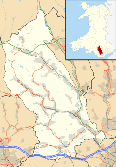
 Miskin shown within Rhondda Cynon Taf
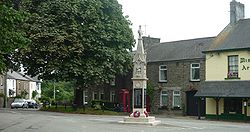
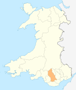
OS grid reference ST044809 Principal area Rhondda Cynon Taf Ceremonial county Mid Glamorgan Country Wales Sovereign state United Kingdom Post town PONTYCLUN Postcode district CF72 Dialling code 01443 Police South Wales Fire South Wales Ambulance Welsh EU Parliament Wales UK Parliament Pontypridd Welsh Assembly Pontypridd List of places: UK • Wales • Rhondda Cynon Taf Miskin (Welsh: Meisgyn) is a village approximately 2 miles south of Llantrisant in the county borough of Rhondda Cynon Taf, Wales.
The origin of the village was a small hamlet known as New Mill, which grew up around New Mill farm. Miskin is part of the Pontyclun electoral ward.
Contents
History
Originally a small hamlet by the name of New Inn, the 1841 census records the settlement as having a population of 31.[1] The opening of the Bute and Mwyndy iron ore mines in nearby Talbot Green in 1852 and 1853 respectively,[2] had a huge impact on the small hamlet of New Mill. The census of 1861 shows that New Mill had become a village. Its population was now 83 people divided in 17 households, of these 83 residents 17 were iron ore miners.[1] By the early 1870s New Mill had become the village of Miskin, with the village centre being based around the inn, which is now The Miskin Arms pub.
The name change from New Mill to Miskin was brought about by Judge Gwilym Williams, and was taken from the medieval commote of Miskin by Williams,[3] a staunch Welsh patriot, he lived at Miskin Manor[3] (built 1864), a Victorian L-plan mansion in a neo-Tudor style.[4]
By the 1870s several ironstone mines are evident to the north of the village, and the village's population continued to grow, as skilled miners rather than heavy labourers, were needed to extract the ore. The 1871 census reveals the village's population as 144, with more than half of the miners, immigrants from the depressed copper mining county of Cornwall.[1]
Religion
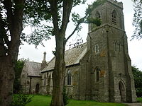
A church has stood at the location of the current St David's church since 1878.[5] Originally of corrugated iron construction, it was replaced by the current stone church in 1906–07. The land on which the church was built was owned by the Williams family.
Funds for the building of the church were raised by public donations and events, notably the Grand Fete at Miskin Manor which raised over £1,000, with the majority of the funds coming from Emma Eleanor Williams, Gwilym Williams' widow.[6] The church was licensed on 23 December 1907 and later consecrated by Right Rev Timothy Rees, Bishop of Llandaff, on Sunday 23 April 1933.[5]
St David's Church was designed by local architect E.M. Bruce Vaughan and has been described as 'earnestly handsome'.[4] The church has an over-buttressed square tower, and is faced with green Quarella stone outside and in. Of note are three stained glass windows by Jessie Bayes (c. 1943-1964), to[clarification needed] members of the Williams family.[4]
There is also a large Roman Catholic church, All Hallows, located on the ourskirts of the village.
Miskin Mill
The Miskin Mill site has been the location of a water driven corn mill for most of the last 400 years. Since 1929 it has been used by the Scouting movement for camping and training.
External links
References
- ^ a b c "Miskin". Rhondda Cynon Taf Library Service. http://webapps.rhondda-cynon-taff.gov.uk/heritagetrail/taff/miskin/miskin.htm. Retrieved 27 July 2010.
- ^ "Talbot Green". Rhondda Cynon Taf Library Service. http://webapps.rhondda-cynon-taff.gov.uk/heritagetrail/taff/talbot_green/talbot_green.html. Retrieved 27 July 2010.
- ^ a b Davies, John; Jenkins, Nigel (2008). The Welsh Academy Encyclopaedia of Wales. Cardiff: University of Wales Press. p. 691. ISBN 9780708319536.
- ^ a b c Newman, John (1995). Glamorgan. London: Penguin Group. p. 450. ISBN 0140710566.
- ^ a b History of St David's Miskin from Parish of Llantrisant website
- ^ Newman, John (1995). Glamorgan. London: Penguin Group. p. 449. ISBN 0140710566.
Categories:- Villages in Rhondda Cynon Taf
- M4 corridor
Wikimedia Foundation. 2010.


