Coed-Ely

Coed-Ely

Coordinates: 51°33′58″N 3°25′01″W / 51.566°N 3.417°W / 51.566; -3.417

Coordinates: 51°33′58″N 3°25′01″W / 51.566°N 3.417°W / 51.566; -3.417

Coed-Ely
Welsh: Coed-Elái
Garth Street, Coedely.jpg
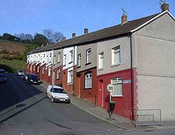
Garth Street, Coed-Ely
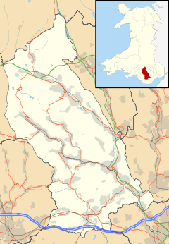
Coed-Ely is located in Rhondda Cynon Taf
Coed-Ely

 Coed-Ely shown within Rhondda Cynon Taf
Principal area Rhondda Cynon Taf
Ceremonial county Mid Glamorgan
Country Wales
Sovereign state United Kingdom
Police South Wales
Fire South Wales
Ambulance Welsh
EU Parliament Wales
UK Parliament Pontypridd
List of places: UK • Wales • Rhondda Cynon Taf

Coed-Ely is a small village located to the south of Tonyrefail in south Wales and is located in the County Borough of Rhondda Cynon Taf. The name Coed-Ely is a derivative of the Welsh words Coed-Elái which can be loosely translated into English as Ely Woods.


Wikimedia Foundation. 2010.

Игры ⚽ Нужен реферат?

Look at other dictionaries:

  • Coed Ely railway station — Coed Ely Location Place Thomastown Area Rhondda Cynon Taf Coordinates …   Wikipedia

  • River Taff — (Afon Taf) River The Taff flowing through Llandaff …   Wikipedia

  • A4119 road — Route information Length: 19.5 mi (31.4 km) History: Construction completed 1995 …   Wikipedia

  • Penarth — infobox UK place country = Wales welsh name= constituency welsh assembly= latitude= 51.43 longitude= 3.17 official name= Penarth unitary wales= Vale of Glamorgan lieutenancy wales= South Glamorgan constituency westminster= Cardiff South Penarth… …   Wikipedia

  • Church Village — Coordinates: 51°34′12″N 3°19′18″W / 51.569920°N 3.321605°W / 51.569920; 3.321605 …   Wikipedia

  • Maerdy — Coordinates: 51°40′22″N 3°29′00″W / 51.672653°N 3.483313°W / 51.672653; 3.483313 …   Wikipedia

  • Cwmaman — For the village in Carmarthenshire, see Cwmamman. Coordinates: 51°41′00″N 3°26′00″W / 51.6833°N 3.4333°W / 51.6833; 3.4333 …   Wikipedia

  • Cwmbach — Coordinates: 51°42′26″N 3°24′46″W / 51.707222°N 3.412778°W / 51.707222; 3.412778 …   Wikipedia

  • Cwmdare — Coordinates: 51°43′00″N 3°28′00″W / 51.716667°N 3.466667°W / 51.716667; 3.466667 …   Wikipedia

  • Dinas Rhondda — Coordinates: 51°37′10″N 3°25′51″W / 51.61948°N 3.43073°W / 51.61948; 3.43073 …   Wikipedia

Share the article and excerpts

Direct link
Do a right-click on the link above
and select “Copy Link”