Dare Valley Country Park

Dare Valley Country Park

Coordinates: 51°43′08″N 3°29′31″W / 51.719°N 3.492°W / 51.719; -3.492

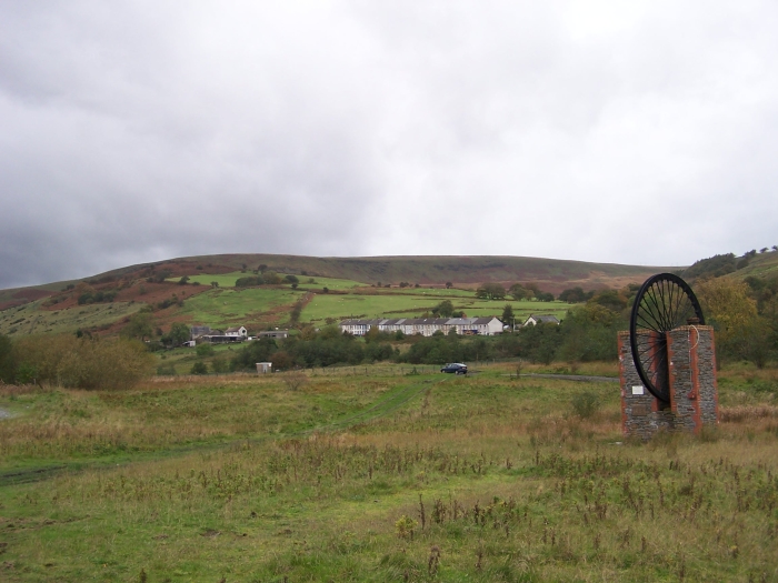
Northern view of the Park showing former pit winding gear of Nant-y-Melyn Colliery

Dare Valley Country Park (Welsh: Parc Gwledig Cwm Dâr) is a public park in Britain. It lies near the village of Cwmdare and the town of Aberdare, Cynon Valley, in Rhondda Cynon Taff, in south Wales. It comprises 500 acres (2.0 km2) of woodlands, pasture and moorland mountainside. It is maintained by the local Council, Rhondda Cynon Taf County Borough Council.

Contents

History

The Park was opened in December 1973. It was built on land reclaimed from over a century of coal mining in the area. The land reclamation took two years and involved the clearing of coal tips and re-routing of the River Dare.

There are many historical remnants of the coal mining past to be seen in the Park, including colliery coal trams, and pit winding gear which forms part of a monument in the northern part of the Park. In 1985 a Visitor Centre was established at the Park.

Two separate railway lines operated in the area operated by rival companies. The Dare and Aman Branch of the Vale of Neath Railway reached the local Bwllfa Colliery in 1857. This railway reached Cwmdare from Gelli Tarw near Llwydcoed, crossing the Gamlyn Viaduct at Penywaun and Dare Viaduct. Both viaducts were designed by Isambard Kingdom Brunel.[1] The second line to Cwmdare was built by the Taff Vale Railway and followed a route near the River Dare from a junction close to Aberdare. This line was opened in 1866.[1]

Feature and Amenities

The Park features two artificial lakes (an upper and lower) with a cascade on the Dare down to the lower lake.

The Park is open all year round and offers free car parking.

See also

External links

References

  1. ^ a b Cwmdare

Wikimedia Foundation. 2010.

Игры ⚽ Поможем написать курсовую

Look at other dictionaries:

  • Aberdare Park — is a well preserved Victorian public park located in the village of Trecynon, near the town of Aberdare in South Wales.HistoryThe park occupies nearly fifty acres (20.25ha). It opened on 27th July 1869. It was landscaped and planted by William… …   Wikipedia

  • Park Ridge, New Jersey — Infobox Settlement official name = Borough of Park Ridge, New Jersey nickname = motto = imagesize = image caption = image imagesize = image caption = image mapsize = 250x200px map caption = Map highlighting Park Ridge s location within Bergen… …   Wikipedia

  • Cwmdare — Coordinates: 51°43′00″N 3°28′00″W / 51.716667°N 3.466667°W / 51.716667; 3.466667 …   Wikipedia

  • Nokrek National Park — Nokrek Biosphere Reserve   national park   Coordinates Country India State …   Wikipedia

  • Glamorgan — Glamorgan …   Deutsch Wikipedia

  • Glamorganshire — Glamorgan oder Glamorganshire (walisisch: Morgannwg) ist eine der dreizehn historischen Grafschaften und früheres County von Wales. Im Mittelalter war Glamorgan ein Königreich oder Fürstentum. In Glamorgan liegen die beiden größten walisischen… …   Deutsch Wikipedia

  • Morgannwg — Glamorgan oder Glamorganshire (walisisch: Morgannwg) ist eine der dreizehn historischen Grafschaften und früheres County von Wales. Im Mittelalter war Glamorgan ein Königreich oder Fürstentum. In Glamorgan liegen die beiden größten walisischen… …   Deutsch Wikipedia

  • Penywaun — is a village situated between Aberdare and Hirwaun, in the county borough of Rhondda Cynon Taff, Wales.BackgroundThe population of Penywaun is approximately 3,300. [http://www.audit commission.gov.uk/neighbourhoodcrime/downloads/example4.pdf]… …   Wikipedia

  • List of children's television series by country — The following is a partial list of television programs for children that have received particular recognition or popularity, listed by their country of origin. Successful children s television programs are often broadcast in multiple countries… …   Wikipedia

  • Rhondda Cynon Taff — ▪ county borough, Wales, United Kingdom       county borough in southern Wales. It encompasses the northwest southeast trending upper valleys of the Rivers Ely, Rhondda, Taff, and Cynon and the wooded hills between them. These hills increase in… …   Universalium

Share the article and excerpts

Direct link
Do a right-click on the link above
and select “Copy Link”