- Chalakudy
-
Chalakkudy
Chalakudy
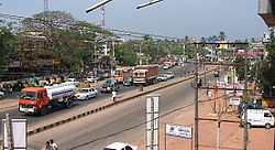
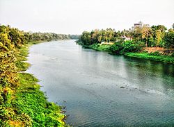
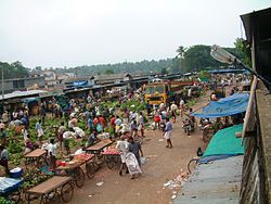
— town — Coordinates 10°18′N 76°20′E / 10.30°N 76.33°ECoordinates: 10°18′N 76°20′E / 10.30°N 76.33°E Country India State Kerala District(s) Thrissur District M L A B.D. Devassy Population 48,371 (2001[update]) Time zone IST (UTC+05:30) Chalakudy is a municipal town situated on the banks of Chalakudy River in Thrissur District of the Kerala State in India. It is the base camp for travellers to Athirappilly and Vazhachal Falls.[1] It lies on National Highway 47 and located about 36 km (23 mi) north of the city of Kochi, the commercial capital city of Kerala and 30 km (19 mi) south of Thrissur, the cultural capital of Kerala.
Contents
History
The name "Chalakudy" is derived from the word "Shalakudy", meaning a place where sacrifices are made. The best season to visit Chalakudy is December to March and also in monsoon season. Chalakkudy is a place of historical importance as it was the base for the operations of the Mysore invader Tipu Sultan while attacking the "Travancore lines'.[2]
Demographics
As of the 2001 census,[3] Chalakudy had a population of 48,371. Males constitute 49% of the population and females 51%. Chalakudy has an average literacy rate of 85%, higher than the national average of 59.5%; with male literacy of 86% and female literacy of 84%. 10% of the population is under 6 years of age.
Government
Chalakkudy Municipality came into existence in the year 1970. The municipality covering an area of 25.23 km2 is divided into 36 electoral wards. The Municipality has a total population of 48,371 with a density of 1,917 per km2. Chalakkudy is a Grade-II municipality.[4] Chalakudi assembly constituency was a segment of Mukundapuram (Lok Sabha constituency).[5] Later it became a segment of Chalakudi (Lok Sabha constituency).
Visitors attraction
- Chalakudy River: It has one of the highest fish diversities in Kerala and second in the whole India
- Divine Retreat Centre, Potta
- Athirappilly Water Falls
- Vazhachal Falls
- Sholayar Dam
- Parambikulam Wildlife Sanctuary
Kodassery
Transport
Road
Located along the National Highway 47, between Kochi and Thrissur. Another major road is State Highway 21 which connects Chalakudy to Vazhachal and ends at the border of Tamil Nadu. Chalakudy has a KSRTC and private bus station in the town only. The KSRTC station provides inter-district and inter-state buses in and around Kerala and outside the state. The private station runs local bus services in to the suburbs of Chalakudy.
Railways
The main rail transport system in Chalakudy is operated by the Southern Railway Zone of Indian Railways, and comes under Trivandrum Railway Division. There are two railway stations in Chalakudy, Divine Nagar Railway Station and Chalakudy Railway Station. Chalakudy and Divine Nagar Railway Station lies in the busy route of Shoranur-Cochin Harbour section. All the passenger trains and some express trains stop here.
Air
The nearest airport is Cochin International Airport in Nedumbassery which is 22 KM from Chalakudy. All the major domestic and international flights are available here. Direct flights are available to Chennai, New Delhi, Mumbai, Bangalore and Kolkata.
Business
Madura Coats, Apollo Tyres, Paulson Distillery, Carborundum Limited, Eddie Current and the Stree Shakti Paper Mills are the major industrial establishments. The Government Press has a division functioning in Chalakkudy. The Peringalkuthu Hydro-electric project is about 42 KM east of Chalakkudy.
Education
The Panampally Memorial Government College, Sacred Hearts Women’s College, Nirmala College, St. James Medical Academy Pharmacy College, Nirmala College of Information Technology, Lakshmi College of Science Technology & Management and Southern college of Engineering & Technology are the major higher educational institutions in Chalakkudy. The ITI here is one of the oldest in the Kerala state.[6]
No Name of School Started In 1 Government Vocational Higher Secondary School 1895 2 Government East High School 1895 3 Government Girls High School 1906 4 St Antony's C.G.H.S, Kottat 1919 5 Government High School, V R Puram 1920 6 Sacred Heart Higher Secondary Girls School 1925 7 K.E.C.U.P School, Potta 2008 8 St Mary's L.P School 1940 9 I.R.M.L.P School 1953 10 Government L.P School 1960 11 Carmel Higher Secondary School 1975 12 C.K.M.N.S.S Higher Secondary School 1980 13 Vyasa Vidyanikethan High School 1996 14 Crescent Public School 1995 15 C.M.I Public School 1998 16 ITI Chalakudy (First ITI In Kerala) 1954 17 Sacred Heart College 18 Panampilly college 1972 See also
- Chalakudy River Protection Forum (CPF)
- Scienetic Technologies Web Design and Software Development @ Chalakudy (CPF)
References
- ^ "‘Kerala tops in rum sales ’". Business Standard. 2010-03-29. http://www.business-standard.com/india/news/kerala-tops-in-rum-sales/21/50/390015/. Retrieved 2010-11-03.
- ^ "Profile". Janasevana Kendram. http://www.janasevanakendram.org/Content/M080400.htm. Retrieved 2010-12-07.
- ^ "Census of India 2001: Data from the 2001 Census, including cities, villages and towns (Provisional)". Census Commission of India. Archived from the original on 2004-06-16. http://web.archive.org/web/20040616075334/http://www.censusindia.net/results/town.php?stad=A&state5=999. Retrieved 2008-11-01.
- ^ "Profile". Janasevana Kendram. http://www.janasevanakendram.org/Content/M080400.htm. Retrieved 2010-12-07.
- ^ "Assembly Constituencies — Corresponding Districts and Parliamentary Constituencies" (PDF). Kerala. Election Commission of India. http://archive.eci.gov.in/se2001/background/S11/KL_Dist_PC_AC.pdf. Retrieved 2008-10-19.
- ^ "Profile". Janasevana Kendram. http://www.janasevanakendram.org/Content/M080400.htm. Retrieved 2010-12-09.
Municipalities of Kerala Neyyattinkara · Nedumangad · Attingal · Varkala · Paravoor South · Punalur · Pathanamthitta · Adoor · Thiruvalla · Alappuzha · Kayamkulam · Mavelikkara · Chenganoor · Cherthala · Kottayam · Changanassery · Vaikom · Palai · Thodupuzha · Muvattupuzha · Kothamangalam · Perumbavoor · Angamaly · Aluva · Kalamassery · Thrikkakara · Thrippunithura · Maradu · Eloor · North Paravur · Kodungallur · Chalakkudy · Irinjalakuda · Chavakkad · Guruvayur · Kunnamkulam · Palakkad · Chittur-Thathamangalam · Ottappalam · Shoranur · Malappuram · Ponnani · Tirur · Kottakkal · Perinthalmanna · Nilambur · Manjeri · Koyilandy · Vadakara · Kalpetta · Kannur · Thalassery · Kuthuparamba · Mattannur · Payyannur · Taliparamba · Kasaragod · Nileshwaram · Kanhangad
Taluks Blocks Anthikad · Chalakudy · Chavakkad · Cherpu · Chowannur · Irinjalakuda · Kodakara · Kodungallur · Mala · Mathilakam · Ollukkara · Pazhayanur · Puzhakkal · Talikulam · WadakkancheryMunicipalities Villages List of villages in Thrissur districtReligious sites Guruvayur Temple · Mammiyur · Vadakkumnathan · Nalambalam · Sri Kurumba Bagvathi Temple, (Kodungallur) · Cheraman Juma Masjid · St. Thomas Church (Palayur) · Pazhanji ChurchTourism Athirapally Falls · Vazhachal Falls · Guruvayur · Chavakkad Beach · Chimmony Wildlife sanctuary · Punnathurkotta · Kerala Kalamandalam · Peechi-Vazhani Wildlife SanctuaryFestivals Education Government Engineering College · Kerala Agricultural University · Government Medical College · College of Veterinary and Animal Sciences · Vimala College · Sree Kerala Varma CollegeDiocese Stations on the Shoranur – Cochin Harbour section Shornur Junction - Ernakulam Junction Route Shornur Junction · Vallathol Nagar · Wadakkancherry · Mulankunnathukavu Railway Station · Poonkunnam Railway Station · Thrissur Railway Station · Ollur Railway Station · Pudukad · Nellayi · Irinjalakuda · Chalakudi · Divine Nagar · Koratty · Karukutty · Angamaly · Aluva · Kalamassery · Edapally · Ernakulam Town · [[]] · Cochin Harbour TerminusCategories:- Trivandrum railway division
- Cities and towns in Thrissur district
Wikimedia Foundation. 2010.


